- Home
- :
- All Communities
- :
- Products
- :
- Geoprocessing
- :
- Geoprocessing Questions
- :
- Re: .csv data not showing where it should
- Subscribe to RSS Feed
- Mark Topic as New
- Mark Topic as Read
- Float this Topic for Current User
- Bookmark
- Subscribe
- Mute
- Printer Friendly Page
.csv data not showing where it should
- Mark as New
- Bookmark
- Subscribe
- Mute
- Subscribe to RSS Feed
- Permalink
Good morning,
Trying to add a .csv file of coordinates (ship AIS positions) to an existing map, the file was added successfully but the data points are not shown on the chart (Channel Islands decca chart). I have double checked that the coordinate systems for both the .msd and the data I'm trying to add are the same, but still no joy. Zooming to the new data layer shows that the points have been added but nowhere near the charted area. I have dragged and dropped the file onto the ArcMap online chart and it shows up as it should, so can anyone recommend why it isn't showing up in my .mxd?
Thanks in advance,
Dan
- Mark as New
- Bookmark
- Subscribe
- Mute
- Subscribe to RSS Feed
- Permalink
A picture would help or the first couple of rows of the csv as well.
If it is way off in terms of position, have you mixed up the X and Y data? commonly data are shown with coordinates as "latitude, longitude" and people assign those to the "X, Y" coordinates, when they should be "Y, X" which is why ... IMHO... coordinates should be recorded "longitude, latitude" but getting people to say this goes against some oft discussed tenant as to how coordinates should be referenced.
If that to discussion doesn't apply, the coordinate system has probably been applyied, described wrong. Enter the file into its own data frame and visually inspect where they are and redefine appropriately
- Mark as New
- Bookmark
- Subscribe
- Mute
- Subscribe to RSS Feed
- Permalink
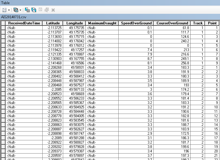
Here is the first couple of rows of the .csv. When prompted by ArcGIS what I want to assign X,Y etc I have assigned lat and long as the correct Y and X coordinates (and even tried it the wrong way round to make sure!) but no joy. The bizarre bit for me is that the coordinates show up fine when the file is added to the free Arcmap online?
- Mark as New
- Bookmark
- Subscribe
- Mute
- Subscribe to RSS Feed
- Permalink
so you defined it a geographic coordinate system (aka decimal degree data) probably a WGS84 version if obtained via gps coordinates. I don't know where you are adding this, but the field names could be shortened and spaces removed and any columns with null values should be removed prior to import. The simplest would be to experiment with other software to see if it is read as well.. DNRGPS is one that I use all the time since it allows you to import/export into a variety of formats. If it can't read it, there is something wrong with the format since it is pretty forgiving. I would try to clean up the file, fix the field names, get rid of extraneous columns. Your Long/Lat (X/Y) should be easily read from that table assuming it is in its own data frame and then you use the Define Projection tool to set it to a Geographic Coordinate system probably WGS84 variant. From there you can project it to whatever you want using the Project tool
- Mark as New
- Bookmark
- Subscribe
- Mute
- Subscribe to RSS Feed
- Permalink
Many thanks for your thoughts. I'll have a play with DNRGPS and see what happens. I'm beginning to suspect that the error may actually be with the chart rather than the AIS data - the chart is not one that I have georectified myself, and have had problems adding GPS data to it previously. I'll get back to you!
- Mark as New
- Bookmark
- Subscribe
- Mute
- Subscribe to RSS Feed
- Permalink
Inside of DNRGPS you can also save the file out to KML which you could bring into Google Earth and see if they are in the right location, or alternately, save as a shape and bring into arc* with a different basemap
- Mark as New
- Bookmark
- Subscribe
- Mute
- Subscribe to RSS Feed
- Permalink
Do you have the Latitude and Longitude columns reversed? If I add a point at Lat -2.11 Long 49.175 into a map, it shows up off the coast of Somalia. If I put it in as Lat 49.175 Long -2.11, it shows up on Jersey
- Mark as New
- Bookmark
- Subscribe
- Mute
- Subscribe to RSS Feed
- Permalink
Ken's right. The latitude and longitude column labels are swapped. When you add the data, you can manually switch them, or edit the table column names first, then add.
Melita
- Mark as New
- Bookmark
- Subscribe
- Mute
- Subscribe to RSS Feed
- Permalink
Of course this swapping of coordinates was suggested in my post but ... sigh... to no avail ... as in the original post which suggest that the correct order was obtained " I have dragged and dropped the file onto the ArcMap online chart and it shows up as it should...
- Mark as New
- Bookmark
- Subscribe
- Mute
- Subscribe to RSS Feed
- Permalink
Exporting to a KML (leaving the data as is) and importing into Google Earth also gives great success, so I'm definitely thinking that its the map that has issues rather than the dataset. Thanks for your help all 