- Home
- :
- All Communities
- :
- Products
- :
- Geoprocessing
- :
- Geoprocessing Questions
- :
- Re: creating polygons using line features
- Subscribe to RSS Feed
- Mark Topic as New
- Mark Topic as Read
- Float this Topic for Current User
- Bookmark
- Subscribe
- Mute
- Printer Friendly Page
- Mark as New
- Bookmark
- Subscribe
- Mute
- Subscribe to RSS Feed
- Permalink
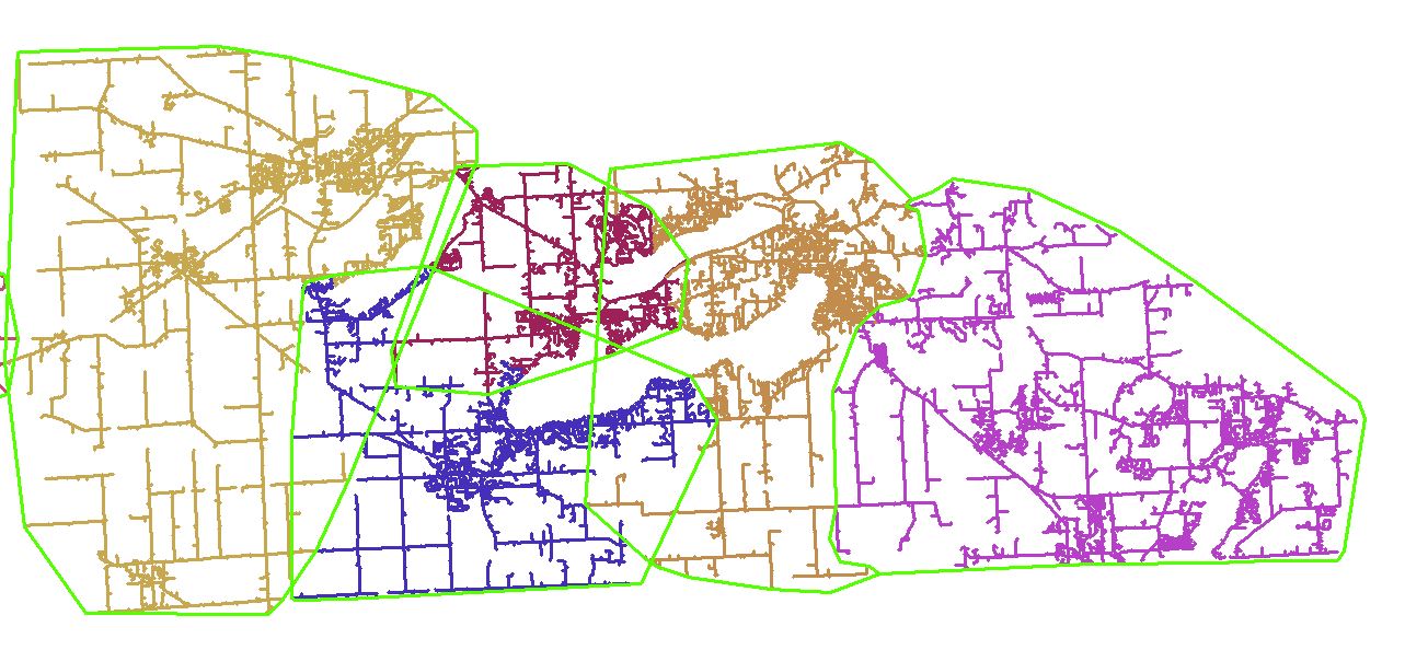
I am trying to create polygon "zones" based on line features. I've tried using 'Minimun Boundry Geometry' but it created overlaps.
Is there a tool that can create these polygons without causing a messy overlap? See samples
Solved! Go to Solution.
Accepted Solutions
- Mark as New
- Bookmark
- Subscribe
- Mute
- Subscribe to RSS Feed
- Permalink
Well, some success, but not perfect. Here's some quick test results of the workflow I suggested:
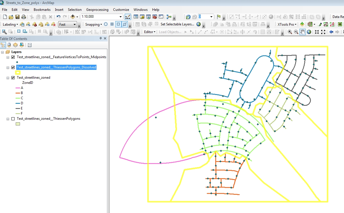
While the process did produce distinct zones (yellow lines), there are issues in that it did not capture street area outside the extents (see pink streets on left side). Also, the zones did not cross exactly at the endpoints where two lines met that had different zone assignments.
In summary, I guess this workflow is sufficient to rough out the zones, but one would have to go back and manually edit the zone polygons to cross right at the street junctions and to extend the polygons if streets are not covered fully.
Chris Donohue, GISP
- Mark as New
- Bookmark
- Subscribe
- Mute
- Subscribe to RSS Feed
- Permalink
1-You could create Grid (very small width and length) for your line feature class. use Create Fishnet—Help | ArcGIS Desktop / or Grid Index Features—Help | ArcGIS Desktop
2- Create Spatial Join—Help | ArcGIS Desktop for the new grid that you create with line feature , to get attribute of (closest) lines.
3- Use Dissolve—Help | ArcGIS Desktop tool using the line classes field as dissolve field.to merge each grids to extent of lines class.
- Mark as New
- Bookmark
- Subscribe
- Mute
- Subscribe to RSS Feed
- Permalink
I have a theoretical workflow that may work (untested), assuming you have an Advanced ArcGIS Desktop license:
1. Use Feature Vertices to Point with the Point Type (optional) set to "Mid" to get the midpoint of each line.
2. Use Create Thiessen Polygons (Analysis) on the points from step 1.
3. Dissolve (Data Management) the resulting polygons based on each group to come up with the final polygon. Note - you may need to first spatial join or select by location the original point information to be able to provide differentiation for the Dissolve (ie so when the Dissolve is run all the polygons representing violet lines dissolve into one polygon, all the polygons representing magenta lines dissolve into one polygon, etc.
Chris Donohue, GISP
- Mark as New
- Bookmark
- Subscribe
- Mute
- Subscribe to RSS Feed
- Permalink
Well, some success, but not perfect. Here's some quick test results of the workflow I suggested:
While the process did produce distinct zones (yellow lines), there are issues in that it did not capture street area outside the extents (see pink streets on left side). Also, the zones did not cross exactly at the endpoints where two lines met that had different zone assignments.
In summary, I guess this workflow is sufficient to rough out the zones, but one would have to go back and manually edit the zone polygons to cross right at the street junctions and to extend the polygons if streets are not covered fully.
Chris Donohue, GISP
- Mark as New
- Bookmark
- Subscribe
- Mute
- Subscribe to RSS Feed
- Permalink
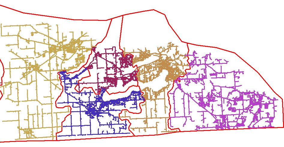
YES!!! Thank you for your suggestion. It worked. To clean it up more, I clipped to a defined territory.
I am going to try the other suggestions tomorrow to test different results.
- Mark as New
- Bookmark
- Subscribe
- Mute
- Subscribe to RSS Feed
- Permalink
Is there a way to create polygon zones around line features and incorporate attributes as some kind of input criteria? Basically I'm looking to create zones (for snowplow routes) with roughly the same drive distance using the shape length and number of lanes attributes. I'm wondering if one of the workflows mentioned above or somehow incorporating the Building Balanced Zones geoprocessing tool would do the trick.