- Home
- :
- All Communities
- :
- Products
- :
- Geoprocessing
- :
- Geoprocessing Questions
- :
- Re: Create points on line between speed limit sign...
- Subscribe to RSS Feed
- Mark Topic as New
- Mark Topic as Read
- Float this Topic for Current User
- Bookmark
- Subscribe
- Mute
- Printer Friendly Page
Create points on line between speed limit signs near the road in ArcGIS 10.4
- Mark as New
- Bookmark
- Subscribe
- Mute
- Subscribe to RSS Feed
- Permalink
I have a road shapefile (lines) and and speed limit signs (points) near the roads. Now I want to create points on every 5m on the roads between these signs so every single created point should have a speed limit information of a speed for that part of road in that direction (for example if I have a road part between signs where the speed limits are from 60 to 80 and the road direction is from sign 60 to sign 80 all created 5m points should have a speed limit information of 60). Also these points must to contain information of roads too.
This is how I have start working:
1. I have joined line attributes to the signs using join by location
tool.
2. I have snapped points to the lines
3. I have split the lines on these snapped points.
4. I have created the points on every 5m on these splited lines.
I
have a few problems now:
- How to join speed limit information on that part of road to these 5m
points?
- How to define direction of road so I can know which speed limit is
on each road part?
- How to solve this for a two directions roads (there is a attribute
field that contain the information is that a one way or two ways
road).
I think the ArcGIS is the best solution for this.
I have attached the files.
Field "sentidoD" have information is that one way or two ways road.
Solved! Go to Solution.
Accepted Solutions
- Mark as New
- Bookmark
- Subscribe
- Mute
- Subscribe to RSS Feed
- Permalink
I would recommend using LRS (Linear Referencing System) especially if you are going to manage the signs along your road system. Quickly looking at your data, your signs do not have a relationship to the road they are on and must be blindly snapped to the closet line which is not always correct...
I can give an outline on how I would address your situation... (there is no quick easy way about it).
First I would create a LRS on your roads layer, perhaps using the the nombre field as your "Route."
- Having a LRS will allow your to "Event Map" without resorting to breaking up your roads into 5m segments....
- You could create a table/dbf/excel that will event map your sign points to the road at whatever interval you want...
- When building your LRS you must determine the inventory route directions for road...
- I use the following rules
- N/S roads would have a direction S to N
- E/W roads would have a direction W to E
- Single Direction roads would be the direction of travel
- When building your LRS all your road segments beg/end parts of the segments must be following your direction rules
- I use the following rules
Next you will have to add a Route field to your signs and populate the field with the corresponding route the sign is on. (This will allow you to event map your signs and get its corresponding Milepoint (reference distance along the line). Some other fields to incorporate to make your management easier:
- Add Route field and populate it
- Add a Sign facing field example ( 1 - Direction of travel, 2 - Opposite Direction of travel) Populate this field... this will allow you to orientate and offset the sign for those signs on roads that have two way traffic
Now you can event map and overlay over your new LRS your speed limits along your road... the overlay will divide out your roads into segments relating to speed limits. You can use the offset to position the signs (right side of road for direction of travel, left side of road for opposite direction of travel).... Information from the road and or signs can be handles by simple SQL queries and joins.
Yes this is a bit of work...but not much more than using the near/split and other routines and still have to manually find and fix exceptions that will occur (namely that you must snap a sign to the closest road...this can lead to many incorrect associations because the physical sign may be closer to another unrelated road...)
Finally you will enjoy the functionality of your new LRS for other projects...
What is linear referencing?—Help | ArcGIS for Desktop to get you started..
Este es mi dos centavos1
- Mark as New
- Bookmark
- Subscribe
- Mute
- Subscribe to RSS Feed
- Permalink
This is amazing! Thanks for a detailed answer. One more thing if you can do... Please, that will be immensely useful for me if you can make some screen record step by step how to do described solution for the example I have attached.
Thanks in advance and also thank you so much for this what you have already send.
- Mark as New
- Bookmark
- Subscribe
- Mute
- Subscribe to RSS Feed
- Permalink
Sorry, as I stated before this is not a quick solution, but one that sets you up with tools for great future benefits and time saving. You can get started by using the help and tutorial from ESRI What is linear referencing?—Help | ArcGIS Desktop
Other youtube videos:Linear Referencing Using ArcGIS - YouTube , How to Create a Event Layer in ArcGIS - YouTube Can provide some assistance in insights to what you can do with your Routes when you have them built.
I and I am sure other folks will be happy to assist you through any specific problem you run into while developing your LRS and performing event overlays.
- Mark as New
- Bookmark
- Subscribe
- Mute
- Subscribe to RSS Feed
- Permalink
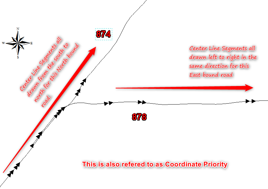
I understand. Could you please explain how to define these direction rules:
- N/S roads would have a direction S to N
- E/W roads would have a direction W to E
- Single Direction roads would be the direction of travel
- Mark as New
- Bookmark
- Subscribe
- Mute
- Subscribe to RSS Feed
- Permalink
This is the direction how the lines are drawn on your center line segments. All the segments should be drawn in the same direction. From this layer you build you routes or LRS. The LRS generally calculates "measures" increasing in value along the road. If you have a segment that is drawn in the wrong direction that portion would "Decrease" in value.