Turn on suggestions
Auto-suggest helps you quickly narrow down your search results by suggesting possible matches as you type.
Cancel
- Home
- :
- All Communities
- :
- Products
- :
- Geoprocessing
- :
- Geoprocessing Questions
- :
- Create New Feature Classes based on an Attribute
Options
- Subscribe to RSS Feed
- Mark Topic as New
- Mark Topic as Read
- Float this Topic for Current User
- Bookmark
- Subscribe
- Mute
- Printer Friendly Page
Create New Feature Classes based on an Attribute
Subscribe
4798
7
01-13-2011 08:28 AM
01-13-2011
08:28 AM
- Mark as New
- Bookmark
- Subscribe
- Mute
- Subscribe to RSS Feed
- Permalink
Does anyone know of a way to export new feature classes based on an attribute? For example, I have a contour layer and I want to export each unique value in the elevation field to it's own feature class. Any ideas...? Thanks!
7 Replies
01-13-2011
09:47 AM
- Mark as New
- Bookmark
- Subscribe
- Mute
- Subscribe to RSS Feed
- Permalink
Does anyone know of a way to export new feature classes based on an attribute? For example, I have a contour layer and I want to export each unique value in the elevation field to it's own feature class. Any ideas...? Thanks!
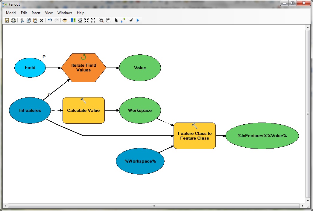
if you want to do this in a model you can use the feature class to feature class tool from the conversion tools/to geodatabase and put the select query in the expression, or just do it one at a time using the same tool
01-14-2011
04:07 AM
- Mark as New
- Bookmark
- Subscribe
- Mute
- Subscribe to RSS Feed
- Permalink
Dan,
I downloaded and tested out your tool. I'm trying to use it with a contour layer. So for every unique elevation, I'd like to create a shapefile for that elevation. When I run your tool, it seems to work for one elevation but all the other elevations are tagged with 'did not work'...any ideas on what I'm doing wrong...?
I downloaded and tested out your tool. I'm trying to use it with a contour layer. So for every unique elevation, I'd like to create a shapefile for that elevation. When I run your tool, it seems to work for one elevation but all the other elevations are tagged with 'did not work'...any ideas on what I'm doing wrong...?
01-14-2011
05:43 AM
- Mark as New
- Bookmark
- Subscribe
- Mute
- Subscribe to RSS Feed
- Permalink
I failed to mention that you should add a new text field and get a text representation of the elevation. Floating point numbers aren't supported directly. If that doesn't work, zip the shapefile and email it to me at Dan_Patterson AT carleton DOT ca and I will have a look
01-14-2011
09:22 AM
- Mark as New
- Bookmark
- Subscribe
- Mute
- Subscribe to RSS Feed
- Permalink
Bruce,
What exactly do I need to change to your model in order to get my data to work? I haven't used iterators before. Some background info on my data:
Contour data is in shapefile format. The 'Elevation' field is a double field type. I'd like to have the resulting shapefiles put in a separate folder if possible.
Questions:
1) Does my data need to be in geodatabase format?
2) Do I need to change the workspace in the model?
07-06-2011
12:17 AM
- Mark as New
- Bookmark
- Subscribe
- Mute
- Subscribe to RSS Feed
- Permalink
1) Does my data need to be in geodatabase format?
If you use in Model Builder, then it is better to convert your data into geodatabase file in order to better fit the application.
2) Do I need to change the workspace in the model?
If you create Personal Geodatabase, then u can use it as a workspace. This is also a good way to make a model.
If you use in Model Builder, then it is better to convert your data into geodatabase file in order to better fit the application.
2) Do I need to change the workspace in the model?
If you create Personal Geodatabase, then u can use it as a workspace. This is also a good way to make a model.