- Home
- :
- All Communities
- :
- Products
- :
- Geoprocessing
- :
- Geoprocessing Questions
- :
- Re: Create a route segment from a point file
- Subscribe to RSS Feed
- Mark Topic as New
- Mark Topic as Read
- Float this Topic for Current User
- Bookmark
- Subscribe
- Mute
- Printer Friendly Page
- Mark as New
- Bookmark
- Subscribe
- Mute
- Subscribe to RSS Feed
- Permalink
Is there a tool that will create a route segment from 2 points that are along a measured route segment defined below? The points table looks like this.
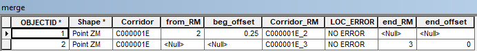
The measure table looks like this.

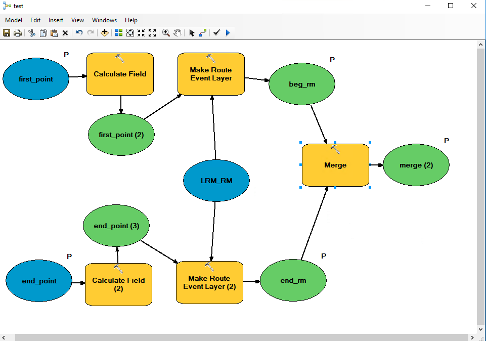
The points were created from another measured layer that has segments for the entire route. In the above example the segment is C000001E_2 and C000001E_3 with corresponding offsets. the make route event layer wont work as the measure table have one route name and an accumulated length. I have created a simple model to create the merge layer that contains the 2 points.
I cant find a tool to create a segment between these 2 points to complete my geoprocessing service. Any help would be greatly appreciated.
Solved! Go to Solution.
Accepted Solutions
- Mark as New
- Bookmark
- Subscribe
- Mute
- Subscribe to RSS Feed
- Permalink
Your route system should be based upon your segments..... So if there is a discrepancy then either one layer is "Wrong" or the two are not related to each other. Without knowing the specifics, my suggestion is to create a Route system based upon your "segmented" layer using the same route name on the segments. You can use the option to accumulated lengths of each segment. The final result would be your own route layer upon which you can event map based upon accumulated mileage that would agree with the segmented on (because you built the layer based upon it)
Generally speaking you should only have one "Route". This will be a measured feature aka (contains the cumulative mileage). In my case I deal with roads. I have only one "Route" for any particular road. Generally it starts at a 0 point (not always) and accumulates measures to its end point. Now if I want and particular "milepost" I can simply event map any point against the "Route" feature. If I want a line segment, I event map the beg and end points against the route for the line segment. Now I understand that sometime there is a need to have multiple routes definitions. I employ actually 3. The primary route feature is defined by the Dual Centerines of each road, On roads going in opposite directions "aka divided highway". In addition we employ a single centerline representation as well as a straight line diagram representation. Although we have 3 route system, they are very carefully designed all based upon our primary definition. All Intersection, cumulative mileages are all exactly the same and agree with each other. The route name is carefully designed for example take State Route 836 -- In our primary route system its name is 83600000E or 83600000W its length is 36 miles. In the Single Centline LRS (Linear Referencing System) aka "Route" layer, the same route is named 83600000CL its length is 36 miles. For out Single Line diagram it is a straight line that is exactly 12 inches long that we create a route of 36 miles on it. Its route name is the same as single centerline. No matter what route layer I use or "Mix Match" I have strict rules that apply -- for names and length. So when I mix & match knowing the Lengths all match for each route all I have to do is programatically deal with the route name differences. Example -- Project Engineer gives me some points from his plans -- engineering plans are based off of single centerline. -- Finance want quantities and representation based upon google maps imagery -- (Dual Centerline). All I do is create, being a VB guy is create a simple script changing the single line name to the double and iterate for both directions.... EB = Left(Single Centerline Name,8) & "EB" and similarly the same for the WB side. Then event map it against our Primary route system
Sorry about the wall of text but it appears you have two LRS systems that are defined much differently and you are trying to use them together. That cannot really happen unless you define yet another blending the rules for both. My suggestion is to use one for your analysis. If the "segmented" one is more accurate for uses then combine all the segments together under one route name....
- Mark as New
- Bookmark
- Subscribe
- Mute
- Subscribe to RSS Feed
- Permalink
I don't quite understand what you are getting at, and I am no model guru .... but the best i can gather is that you are trying to event map a line. To do this all that is required is a route, begin measure, and an end measure.
This may help you get started. About adding route events—Help | ArcGIS for Desktop
- Mark as New
- Bookmark
- Subscribe
- Mute
- Subscribe to RSS Feed
- Permalink
Basically I have 2 different measured route layers. One that has the route and the accumulated mileage. The second has segments for each route going from mile post to mile post. Each of those segments is named C000001E_1 the 1 is denoting the mile post. I can enter the route C000001E and the mile post and offset for the segment layer and it returns the location of the start and end point that I'm looking for. I cant use the accumulated offset layer as the event layer for a couple reasons. In the event input table the Corridor_RM is the route name and in the accumulated mileage layer there is only the corridor name like C000001E and the shape length. the second reason I cant use it is because off long and short mile post locations. I might enter a mile post and offset from the mile post and offset layer and the point lands before or after the location returned from the accumulated mileage layer. I tried splitting the line from the 2 points but that will not work as I really only want a temp line from the entered points.
- Mark as New
- Bookmark
- Subscribe
- Mute
- Subscribe to RSS Feed
- Permalink
Your route system should be based upon your segments..... So if there is a discrepancy then either one layer is "Wrong" or the two are not related to each other. Without knowing the specifics, my suggestion is to create a Route system based upon your "segmented" layer using the same route name on the segments. You can use the option to accumulated lengths of each segment. The final result would be your own route layer upon which you can event map based upon accumulated mileage that would agree with the segmented on (because you built the layer based upon it)
Generally speaking you should only have one "Route". This will be a measured feature aka (contains the cumulative mileage). In my case I deal with roads. I have only one "Route" for any particular road. Generally it starts at a 0 point (not always) and accumulates measures to its end point. Now if I want and particular "milepost" I can simply event map any point against the "Route" feature. If I want a line segment, I event map the beg and end points against the route for the line segment. Now I understand that sometime there is a need to have multiple routes definitions. I employ actually 3. The primary route feature is defined by the Dual Centerines of each road, On roads going in opposite directions "aka divided highway". In addition we employ a single centerline representation as well as a straight line diagram representation. Although we have 3 route system, they are very carefully designed all based upon our primary definition. All Intersection, cumulative mileages are all exactly the same and agree with each other. The route name is carefully designed for example take State Route 836 -- In our primary route system its name is 83600000E or 83600000W its length is 36 miles. In the Single Centline LRS (Linear Referencing System) aka "Route" layer, the same route is named 83600000CL its length is 36 miles. For out Single Line diagram it is a straight line that is exactly 12 inches long that we create a route of 36 miles on it. Its route name is the same as single centerline. No matter what route layer I use or "Mix Match" I have strict rules that apply -- for names and length. So when I mix & match knowing the Lengths all match for each route all I have to do is programatically deal with the route name differences. Example -- Project Engineer gives me some points from his plans -- engineering plans are based off of single centerline. -- Finance want quantities and representation based upon google maps imagery -- (Dual Centerline). All I do is create, being a VB guy is create a simple script changing the single line name to the double and iterate for both directions.... EB = Left(Single Centerline Name,8) & "EB" and similarly the same for the WB side. Then event map it against our Primary route system
Sorry about the wall of text but it appears you have two LRS systems that are defined much differently and you are trying to use them together. That cannot really happen unless you define yet another blending the rules for both. My suggestion is to use one for your analysis. If the "segmented" one is more accurate for uses then combine all the segments together under one route name....