Turn on suggestions
Auto-suggest helps you quickly narrow down your search results by suggesting possible matches as you type.
Cancel
- Home
- :
- All Communities
- :
- Products
- :
- Geoprocessing
- :
- Geoprocessing Questions
- :
- Re: Combine polygons by capturedate
Options
- Subscribe to RSS Feed
- Mark Topic as New
- Mark Topic as Read
- Float this Topic for Current User
- Bookmark
- Subscribe
- Mute
- Printer Friendly Page
08-11-2012
02:37 AM
- Mark as New
- Bookmark
- Subscribe
- Mute
- Subscribe to RSS Feed
- Permalink
hello,
I captured influenced areas of grasslands once a week and noted different subtype features (polygons) over areas, depending on the degree of influence.
Is it possible to combine theses polygons as "one event/one polygon - even tough they are often not conjoined" for further spatial calculations - by using capturedate plus location on the same field as criterion?
[ATTACH=CONFIG]16858[/ATTACH]
Best regards
Andreas
Solved! Go to Solution.
1 Solution
Accepted Solutions
08-25-2012
06:15 PM
- Mark as New
- Bookmark
- Subscribe
- Mute
- Subscribe to RSS Feed
- Permalink
What was the problem with the Spatial Join and Dissolve? I am certain they will work if you do it with the One-To-Many option as far as I can see. I assume the field shape has no date and that only the influence areas are dated. If that is the case it does not matter if they cut up. If you need to compare to a complete polygon's area, precalulate that into the shapes and use it for percentage comparisons with the Min summary. Anyway, the influence areas should not mix at all with the One-To-Many option.
So do it an then post pictures of the results if you still do not know how to get what you want. (Next time post shots of the tableviews of the field and influence areas and tell us what fields you need to combine from each).
So do it an then post pictures of the results if you still do not know how to get what you want. (Next time post shots of the tableviews of the field and influence areas and tell us what fields you need to combine from each).
9 Replies
08-13-2012
05:59 AM
- Mark as New
- Bookmark
- Subscribe
- Mute
- Subscribe to RSS Feed
- Permalink
hello,
I captured influenced areas of grasslands once a week and noted different subtype features (polygons) over areas, depending on the degree of influence.
Is it possible to combine theses polygons as "one event/one polygon - even tough they are often not conjoined" for further spatial calculations - by using capturedate plus location on the same field as criterion?
[ATTACH=CONFIG]16858[/ATTACH]
Best regards
Andreas
Hello Andreas,
If I understand your question correctly, it sounds like you want to use the Dissolve tool. Under the "Dissolve Field(s)" option, choose the date field in your feature class. If the "create multipart features" box is checked, this will combine all polygons with the same date into a single polygon feature. If you would rather only combine polygons when are contiguous, uncheck the box. You will then have several polygons with the same date as several features.
Mike
08-16-2012
05:55 AM
- Mark as New
- Bookmark
- Subscribe
- Mute
- Subscribe to RSS Feed
- Permalink
Sounds good and could be the wright direction, but when i now dont missunderstood you: how can i automatically combine "influence"polygons (the blue/black/red polygons in the attachment) which have the same date AND are within one same "field"polygon (the green and yellow polygons in the attachment) ?
Independent if the influencepolygons touch each other or not. That's not importent.
best regards
andreas
Independent if the influencepolygons touch each other or not. That's not importent.
best regards
andreas
08-16-2012
03:06 PM
- Mark as New
- Bookmark
- Subscribe
- Mute
- Subscribe to RSS Feed
- Permalink
Sounds good and could be the wright direction, but when i now dont missunderstood you: how can i automatically combine "influence"polygons (the blue/black/red polygons in the attachment) which have the same date AND are within one same "field"polygon (the green and yellow polygons in the attachment) ?
Independent if the influencepolygons touch each other or not. That's not importent.
best regards
andreas
Andreas,
I would recommend this:
1) Spatial Join the "field" polygons to the "influence" polygons. This will give you the attributes of the "field" polygons that intersect (or some other criteria, the tool has several to choose from) the "influence" polygons. The Intersect tool may be more appropriate if your "influence" polygons overlap more than one "field" or you only want the area contained within the fields.
2) Dissolve the result. Choose the date and field type attributes by which to dissolve; you will then end up with a single polygon for each date that are within a particular field type.
Hope that helps
08-20-2012
02:17 PM
- Mark as New
- Bookmark
- Subscribe
- Mute
- Subscribe to RSS Feed
- Permalink
that could do it, but i've captured this influence polygons over a year and there are often influence polys lying upon another in fact, that there were "influce=damaged sods" often on the same location again (but with another date)?
best regards
andreas
best regards
andreas
08-24-2012
01:45 AM
- Mark as New
- Bookmark
- Subscribe
- Mute
- Subscribe to RSS Feed
- Permalink
so i need to join the data of every "influence"polygon with the "field"polygon where they are lying on, but in a way that the lying upon another "influence"polygons dont get the data from each other, just from the field. (sorry for my cruel english in this case..)
or is this possible with the dissolve tool/spatial join and i did something wrong?
best regards
andreas
or is this possible with the dissolve tool/spatial join and i did something wrong?
best regards
andreas
08-24-2012
09:08 AM
- Mark as New
- Bookmark
- Subscribe
- Mute
- Subscribe to RSS Feed
- Permalink
so i need to join the data of every "influence"polygon with the "field"polygon where they are lying on, but in a way that the lying upon another "influence"polygons dont get the data from each other, just from the field. (sorry for my cruel english in this case..)
or is this possible with the dissolve tool/spatial join and i did something wrong?
best regards
andreas
I do not follow what you want to do. The Spatial Join/Dissolve technique should be able to handle keeping influence polygons matched to valid field polygons with the proper use of the One-To-Many option and the One-To-One option for the Spatial Join, selecting valid combinations and selecting the appropriate list of fields to use in the Dissolve. A picture is worth a thousand words (whether in perfect english or broken english), so screenshot and upload a picture that gives an example of what you want and what you don't want.
08-25-2012
01:59 PM
- Mark as New
- Bookmark
- Subscribe
- Mute
- Subscribe to RSS Feed
- Permalink
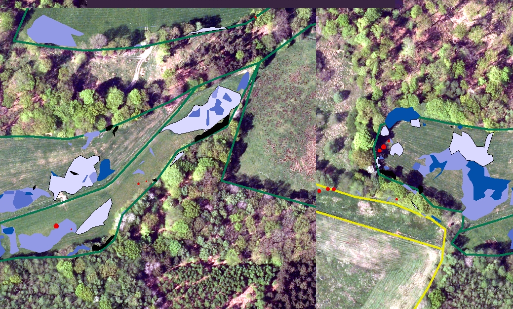
[ATTACH=CONFIG]17238[/ATTACH]
sorry for complicate description.
on the attached picture you can see one fieldpolygon (green frame) and many blue "influence-polygons" which are recorded over a year (with a mobilemapper).
The blue polygons are sometimes upon another with different record dates. (e.g. the dark blue are above the light blue polygon)
1) Now i want to summarize the shape area from influence polygons from the same field and with the same capture date to calculate further, how much influence was on field type x in a special time span, how much on field type y..
And i was not sure in fact that the influence polygons are upon another.
best regards
andreas
08-25-2012
06:15 PM
- Mark as New
- Bookmark
- Subscribe
- Mute
- Subscribe to RSS Feed
- Permalink
What was the problem with the Spatial Join and Dissolve? I am certain they will work if you do it with the One-To-Many option as far as I can see. I assume the field shape has no date and that only the influence areas are dated. If that is the case it does not matter if they cut up. If you need to compare to a complete polygon's area, precalulate that into the shapes and use it for percentage comparisons with the Min summary. Anyway, the influence areas should not mix at all with the One-To-Many option.
So do it an then post pictures of the results if you still do not know how to get what you want. (Next time post shots of the tableviews of the field and influence areas and tell us what fields you need to combine from each).
So do it an then post pictures of the results if you still do not know how to get what you want. (Next time post shots of the tableviews of the field and influence areas and tell us what fields you need to combine from each).
08-26-2012
02:15 PM
- Mark as New
- Bookmark
- Subscribe
- Mute
- Subscribe to RSS Feed
- Permalink
What was the problem with the Spatial Join and Dissolve? I am certain they will work if you do it with the One-To-Many option as far as I can see. I assume the field shape has no date and that only the influence areas are dated. If that is the case it does not matter if they cut up. If you need to compare to a complete polygon's area, precalulate that into the shapes and use it for percentage comparisons with the Min summary. Anyway, the influence areas should not mix at all with the One-To-Many option.
So do it an then post pictures of the results if you still do not know how to get what you want. (Next time post shots of the tableviews of the field and influence areas and tell us what fields you need to combine from each).
it worked with the suggested dissolve method!
I didnt knew the one-to-many option, so i thougt i need to merge/combine the polygons and that overlapping will be a problem etc..
thank you! solved!
best regards
andreas