- Home
- :
- All Communities
- :
- Products
- :
- Geoprocessing
- :
- Geoprocessing Questions
- :
- Calculating coordinates in different coordinate sy...
- Subscribe to RSS Feed
- Mark Topic as New
- Mark Topic as Read
- Float this Topic for Current User
- Bookmark
- Subscribe
- Mute
- Printer Friendly Page
Calculating coordinates in different coordinate system programmatically
- Mark as New
- Bookmark
- Subscribe
- Mute
- Subscribe to RSS Feed
- Permalink
I know when you right click on a field in the attribute table and select "Calculate Geometry" that you have the option to use the Data Frame's coordinate system. Is there a way to do this programmatically?
I've tried this function call and definition:
Lat(!Shape!)

def Lat(shape):
  arcpy.env.cartographicCoordinateSystem = "Coordinate Systems\Geographic Coordinate\Systems\World\WGS 1984.prj"
  lat = shape.centroid.x
  return lat
but it returns the x coordinate in the the same projection of the feature class rather than longitude.
- Mark as New
- Bookmark
- Subscribe
- Mute
- Subscribe to RSS Feed
- Permalink
http://help.arcgis.com/en/arcgisdesktop/10.0/help/index.html#/Setting_a_cursor_s_spatial_reference/0...
Then the "Shape" field's coordinate values will be reported in whatever coordinate system you specified...
- Mark as New
- Bookmark
- Subscribe
- Mute
- Subscribe to RSS Feed
- Permalink
If anyone is interested, here's my updated code for a script tool with a multivalue parameter.
import arcpy

latLonRef = "Coordinate Systems\Geographic Coordinate Systems\World\WGS 1984.prj"

featureClasses = arcpy.GetParameterAsText(0)

featureClassesList = featureClasses.split(";")

for featureClass in featureClassesList:
 arcpy.AddMessage("Calculating XY coordinates for: " + featureClass)
 arcpy.AddField_management(featureClass, "LAT", "DOUBLE")
 arcpy.AddField_management(featureClass, "LON", "DOUBLE")
 rows = arcpy.UpdateCursor(featureClass, "", latLonRef)
 for row in rows:
  feat = row.shape
  coord = feat.getPart()
  lon = coord.X
  lat = coord.Y
  row.LAT = lat
  row.LON = lon
  rows.updateRow(row)
  #arcpy.AddMessage(str(lat) + ", " + str(lon))
- Mark as New
- Bookmark
- Subscribe
- Mute
- Subscribe to RSS Feed
- Permalink
- Mark as New
- Bookmark
- Subscribe
- Mute
- Subscribe to RSS Feed
- Permalink
You sir are a gentlemen and a scholar. That's exactly what I was looking for.
If anyone is interested, here's my updated code for a script tool with a multivalue parameter.import arcpy latLonRef = "Coordinate Systems\Geographic Coordinate Systems\World\WGS 1984.prj" featureClasses = arcpy.GetParameterAsText(0) featureClassesList = featureClasses.split(";") for featureClass in featureClassesList: arcpy.AddMessage("Calculating XY coordinates for: " + featureClass) arcpy.AddField_management(featureClass, "LAT", "DOUBLE") arcpy.AddField_management(featureClass, "LON", "DOUBLE") rows = arcpy.UpdateCursor(featureClass, "", latLonRef) for row in rows: feat = row.shape coord = feat.getPart() lon = coord.X lat = coord.Y row.LAT = lat row.LON = lon rows.updateRow(row) #arcpy.AddMessage(str(lat) + ", " + str(lon))
this is great; how would one modify to calc. area?
thanks!
- Mark as New
- Bookmark
- Subscribe
- Mute
- Subscribe to RSS Feed
- Permalink
import arcpy
latLonRef = "Coordinate Systems\Geographic Coordinate Systems\World\WGS 1984.prj"
featureClasses = arcpy.GetParameterAsText(0)
featureClassesList = featureClasses.split(";")
for featureClass in featureClassesList:
arcpy.AddMessage("Calculating XY coordinates for: " + featureClass)
arcpy.AddField_management(featureClass, "LAT", "DOUBLE")
arcpy.AddField_management(featureClass, "LON", "DOUBLE")
rows = arcpy.UpdateCursor(featureClass, "", latLonRef)
for row in rows:
feat = row.getValue("shape")
cent = feat.centroid
# To get the polygon area: cent = feat.area
row.LAT = cent.Y
row.LON = cent.X
rows.updateRow(row)
#arcpy.AddMessage(str(lat) + ", " + str(lon))
- Mark as New
- Bookmark
- Subscribe
- Mute
- Subscribe to RSS Feed
- Permalink
This works for what I wanted except it locks up ArcMap 10.2.2 when I run it. When I check the attribute table the columns are created and populated. Any ideas why this would "freeze up" ArcMap and not continue the other request in the script?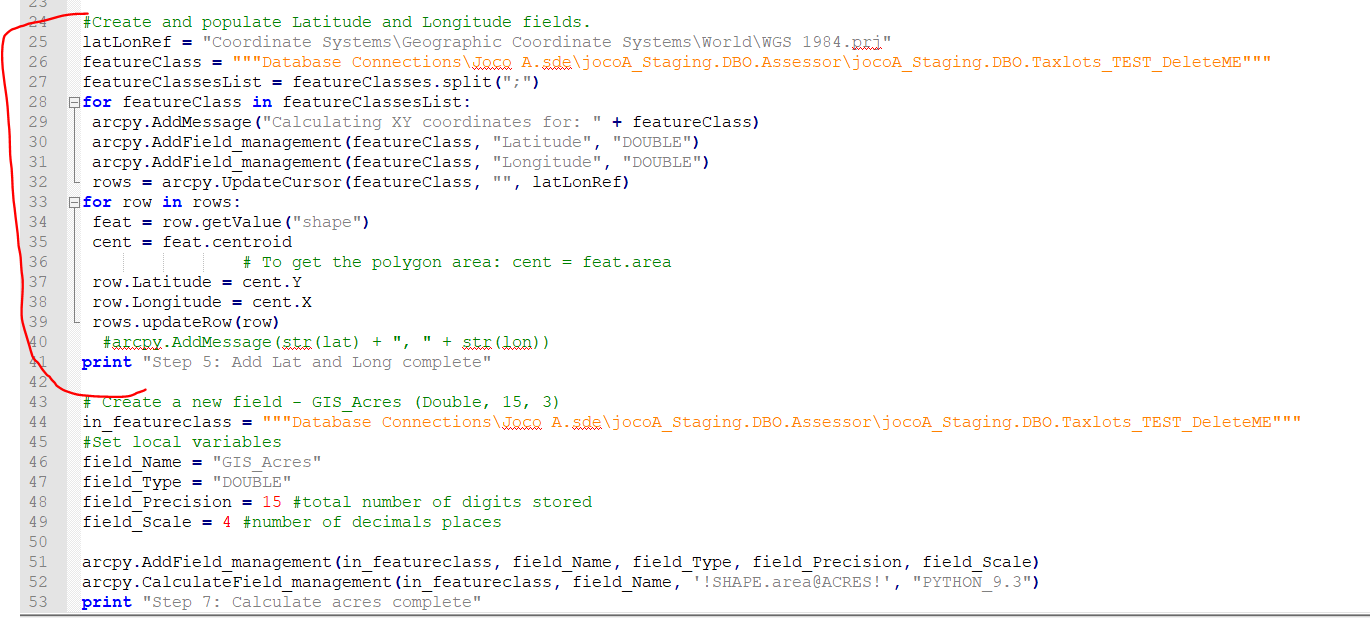
Any suggestions would be appreciated!
Addendum: Okay, I wasn't patient enough. It takes almost 30 minutes for the lat long function to run. It will then complete the python script. Not sure why it takes so long. I am wondering if it has something to do with it being in a Sql GDB? After testing the lat long it looks like they are in the GDB projection (state plane) not WGS84, which is what I wanted. I am going to try Plan B and set up a staging file to add the fields and calculations in a shapefile then copy to the GDB.
- Mark as New
- Bookmark
- Subscribe
- Mute
- Subscribe to RSS Feed
- Permalink
I have a gdb (v9.3) with several feat. datasets. All the feat. datasets are unprojected, coor. system set to WGS1984. I can calc. coord_x and coord_y fields of the point feat. classes fine using the below code, all is well.
Once the script hits a polygon feat. class, I would like to calc. the area_size field to area - acres. At present, the code doesn't calculate anything, even with the polyref pointing to a projected, .prj file.
At the bottom, in the 'polygon' section, you'll see a commented out section:
#expression = "!shape.area@acres!"
 #gp.CalculateField_management(fc, fn, expression, "PYTHON_9.3")
When this is uncommented, (and the updatecursor method commented out) it calculates area just fine, but of course, since the feat. class is unprojected, it calc.s area_size to 1.4857433E-06, which obiv. is in WGS84 DD.
Any thoughts?
thanks!
# Import system modules
import arcgisscripting, os

gp = arcgisscripting.create(9.3)

# Load required toolboxes...
#gp.AddToolbox("C:/Program Files/ArcGIS/ArcToolbox/Toolboxes/Data Management Tools.tbx")
gp.AddToolbox("C:/Program Files/ArcGIS/Desktop10.0/ArcToolbox/Toolboxes/Data Management Tools.tbx")

#gp.workspace = r"G:\\63D RRC GIS Data\\63D_RSC_GDB"
gp.workspace = r"C:\\temp\\python"
#gp.workspace = r"G:\\63D RRC GIS Data"

pathwrksp = gp.workspace
# print pathwrksp
PointRef = r"C:\\Program Files\\ArcGIS\\Desktop10.0\\Coordinate Systems\\Geographic Coordinate Systems\\World\\WGS 1984.prj"
PolyRef = r"C:\\Program Files\\ArcGIS\\Desktop10.0\\Coordinate Systems\\Projected Coordinate Systems\\Continental\\North America\\USA Contiguous Albers Equal Area Conic USGS.prj"


path2wrksps = gp.ListWorkspaces("OK002*")

for path2wrksp in path2wrksps:
    #print "... " + path2wrksp
    gp.workspace = path2wrksp
    facil_id = str(path2wrksp[34:39])
    instln_id = "06510"
    #print facil_id
    wrksps3 = gp.ListWorkspaces("*", "FileGDB")
    for wrksp3 in wrksps3:
        gp.workspace = wrksp3
        print "...... " + gp.workspace
        datasets = gp.ListDatasets("cad*")
        for dataset in datasets:
            gp.workspace = wrksp3 + "\\" + dataset
            #print dataset
            FcList = gp.ListFeatureClasses("*","Point")
            for fc in FcList:
                gp.workspace = dataset + "\\" + fc
                if fc <> "soil_map_unit_area":
                    if fc <> "wetland_area":
                        if fc <> "flood_zone_area":
                            print fc
                            #if gp.exists("vehicle_parking_area"):
                            rows = gp.UpdateCursor(fc, "", PointRef)
                            for row in rows:
                                allFields = gp.listfields(fc)
                                print fc
                                for field in allFields:
                                    fn = field.name
                                    if fn == "coord_x":
                                        feat = row.shape
                                        coord = feat.getPart()
                                        lon = coord.X
                                        row.coord_x = lon
                                        rows.updateRow(row)
                                        print fc, fn + " calculated to long"
                                    elif fn == "coord_y":
                                        feat = row.shape
                                        coord = feat.getPart()
                                        lat = coord.Y
                                        row.coord_y = lat
                                        rows.updateRow(row)
                                        print fc, fn + " calculated to lat"
            FcList = gp.ListFeatureClasses("*","Polygon")
            for fc in FcList:
                gp.workspace = dataset + "\\" + fc
                if fc <> "soil_map_unit_area":
                    if fc <> "wetland_area":
                        if fc <> "flood_zone_area":
                            print fc
                            rows = gp.UpdateCursor(fc, "", PolyRef)
                            for row in rows:
                                allFields = gp.listfields(fc)
                                print fc
                                for field in allFields:
                                    fn = field.name
                                    if fn == "area_size":
                                        feat = row.getValue("SHAPE")
                                        cent = feat.area
                                        rows.updateRow(row)
                                        #expression = "!shape.area@acres!"
                                        #gp.CalculateField_management(fc, fn, expression, "PYTHON_9.3")
                                        print fc, fn + " calculated to area"
- Mark as New
- Bookmark
- Subscribe
- Mute
- Subscribe to RSS Feed
- Permalink
For reporting purposes, I also need to have Lat/Lon fields populated as well for each of those same features (point). How can I use Calculate Field, or Calculate X, Y, or Add X, Y to take the State Plane coordinates in those fields to calculate and populate the Lat/Lon fields? I'm not a programmer, so step by step instructions would be very much appreciated. Thanks.
- Mark as New
- Bookmark
- Subscribe
- Mute
- Subscribe to RSS Feed
- Permalink
1. Start with a new ArcMap document, then double click on 'layers' in the table of contents
2. in data frame properties, go to coordinate system tab/ predefined/ geographic coor system/world/wgs84
3. hit "ok, then "yes" on the warning
4. add your feat classes
5. create 2 new fields, named 'lat' and 'long'
6. right click on the field and choose 'calc geometry'
7. select 'y coordinate of a point' then select 'use coordinate system of the dataframe' units 'decimal degrees'
8. you now have a column of latitude coordinates.
9. do the same for 'long' field.
remember, x measures distance E/W of Prime Meridian, y measures N/S of equator