- Home
- :
- All Communities
- :
- Products
- :
- Geoprocessing
- :
- Geoprocessing Questions
- :
- Bounding Polygon for Complex Feature Set
- Subscribe to RSS Feed
- Mark Topic as New
- Mark Topic as Read
- Float this Topic for Current User
- Bookmark
- Subscribe
- Mute
- Printer Friendly Page
Bounding Polygon for Complex Feature Set
- Mark as New
- Bookmark
- Subscribe
- Mute
- Subscribe to RSS Feed
- Permalink
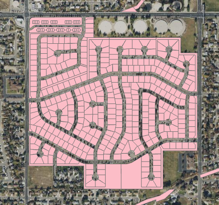
We are looking to dissolve adjacent and nearby parcel geometry that we have identified and attributed as participating in a common subdivision, and merge these into a single, bounding, space filling polygon that closely approximates the outer boundary of the area. (mocked up in the attached images).
The existing geoprocessing envelope tools that we are aware are only able to produce envelopes or convex hulls. As we have thousands of these, we are hoping to avoid manual editing touches where possible. But even tool or process that isn't perfect it would be nice to give even if minor cleanup is still needed.
- Mark as New
- Bookmark
- Subscribe
- Mute
- Subscribe to RSS Feed
- Permalink
Hey Bert- what have you used and what is the desired result? Do you want to have the right of ways dissolved out as well so you have a 'solid' subdivision polygon? (SLCo has such a feature layer...)
- Mark as New
- Bookmark
- Subscribe
- Mute
- Subscribe to RSS Feed
- Permalink
do. Good to know about the county's subdivision dataset. That would work if
the PUDs are broken up according to different housing type areas
(townhouses, single family, condos etc).
- Mark as New
- Bookmark
- Subscribe
- Mute
- Subscribe to RSS Feed
- Permalink
It's not that detailed, just a subdivision name is all.
https://slco.org/slcogis/rest/services/Administration/MapServer/1/