Turn on suggestions
Auto-suggest helps you quickly narrow down your search results by suggesting possible matches as you type.
Cancel
- Home
- :
- All Communities
- :
- Products
- :
- Geoprocessing
- :
- Geoprocessing Questions
- :
- Re: Automatically extending polygons (municipaliti...
Options
- Subscribe to RSS Feed
- Mark Topic as New
- Mark Topic as Read
- Float this Topic for Current User
- Bookmark
- Subscribe
- Mute
- Printer Friendly Page
Automatically extending polygons (municipalities) into maritime areas: possible?
Subscribe
02-01-2012
04:29 AM
- Mark as New
- Bookmark
- Subscribe
- Mute
- Subscribe to RSS Feed
- Permalink
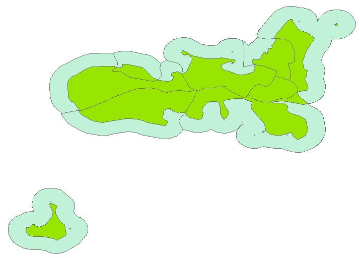
I'd need to extend administrative areas that are along the coast, by a given distance, so that it becomes possible to assign point records off the coast to the corresponding municipality. I can of course create buffers and only retain those that are on the ocean side, but then I end up with a lot of overlapping polygons. Any way that these overlapping features (within the same layer) can be automatically processed in order to generate an appropriate boundary between each municipality's maritime "domain"?
I've attached an example of what I'd need to obtain.
Any help would be greatly appreciated!
I've attached an example of what I'd need to obtain.
Any help would be greatly appreciated!
Solved! Go to Solution.
1 Solution
Accepted Solutions
02-01-2012
09:37 AM
- Mark as New
- Bookmark
- Subscribe
- Mute
- Subscribe to RSS Feed
- Permalink
I know exactly what you want, but such tool may not exist in ArcGIS. However, if you have Spatial Analyst extention, the Euclidean Allocation tool (Distance toolset) might be helpful: it takes source features (your polygons) and grows it in raster by a specified distance, cellsize, and a specified field (e.g. OBJECTID). The cells carrying the unique polygon OBJECTIDs will meet at along an "equal-distance" line. You can then convert the resulting raster back to polygons . You may need to inspect the connection points; the smaller the cellsize you use, the longer the process takes, but the more accurate/finer lines you get.
6 Replies
02-01-2012
09:37 AM
- Mark as New
- Bookmark
- Subscribe
- Mute
- Subscribe to RSS Feed
- Permalink
I know exactly what you want, but such tool may not exist in ArcGIS. However, if you have Spatial Analyst extention, the Euclidean Allocation tool (Distance toolset) might be helpful: it takes source features (your polygons) and grows it in raster by a specified distance, cellsize, and a specified field (e.g. OBJECTID). The cells carrying the unique polygon OBJECTIDs will meet at along an "equal-distance" line. You can then convert the resulting raster back to polygons . You may need to inspect the connection points; the smaller the cellsize you use, the longer the process takes, but the more accurate/finer lines you get.
02-02-2012
03:42 AM
- Mark as New
- Bookmark
- Subscribe
- Mute
- Subscribe to RSS Feed
- Permalink
Many thanks Dan for your prompt response. I'll give this a try and let you know how it goes.
If anyone has other suggestions I'd be happy to hear about them.
Thanks.
If anyone has other suggestions I'd be happy to hear about them.
Thanks.
02-02-2012
05:08 AM
- Mark as New
- Bookmark
- Subscribe
- Mute
- Subscribe to RSS Feed
- Permalink
Perhaps if you convert the verticies of the shore line to points with a 'minicipality' attribute
(making sure the shore line breaks at the municipal bounds), then run
CreateThiessenPolygons_analysis (in_features, out_feature_class, {fields_to_copy})
quote: The outside boundary of the output Thiessen polygon feature class is the extent of the point input features plus an additional 10%. If the Extent environment is set to a specific extent window, this tool tool will use the environment setting to set its outside boundary.
:unquote
Then clip to the buffer (which will have been smaller than the Extent environment or the 10%),
erase the land area, and dissolve on 'municipality'.
You should get polygons with areas closest to the shore of each municipality.
Alternatly, you could run a Near analysis on your offshore points to identify the nearest on-shore municipality polygon to each point.
02-03-2012
01:11 AM
- Mark as New
- Bookmark
- Subscribe
- Mute
- Subscribe to RSS Feed
- Permalink
Many thanks for your suggestion, which indeed may work out well. Haven't had the chance to work on this yet, will let you all know how it goes once I get round to taking care of this task.
Best regards,
bram
Best regards,
bram
02-08-2012
11:56 AM
- Mark as New
- Bookmark
- Subscribe
- Mute
- Subscribe to RSS Feed
- Permalink
Hi all,
The Euclidian Allocation tool (Spatial Analyst) worked out very well, and I managed to obtain what I wanted.
Again, many thanks for your suggestions.
Bram
The Euclidian Allocation tool (Spatial Analyst) worked out very well, and I managed to obtain what I wanted.
Again, many thanks for your suggestions.
Bram
02-09-2012
01:52 PM
- Mark as New
- Bookmark
- Subscribe
- Mute
- Subscribe to RSS Feed
- Permalink
You are welcome. I am glad the Euclidian Allocation tool (Spatial Analyst) worked for you. 🙂