- Home
- :
- All Communities
- :
- Products
- :
- Geoprocessing
- :
- Geoprocessing Questions
- :
- Re: Are Multiple Ring Buffer Boundaries Inclusive ...
- Subscribe to RSS Feed
- Mark Topic as New
- Mark Topic as Read
- Float this Topic for Current User
- Bookmark
- Subscribe
- Mute
- Printer Friendly Page
Are Multiple Ring Buffer Boundaries Inclusive or Exclusive?
- Mark as New
- Bookmark
- Subscribe
- Mute
- Subscribe to RSS Feed
- Permalink
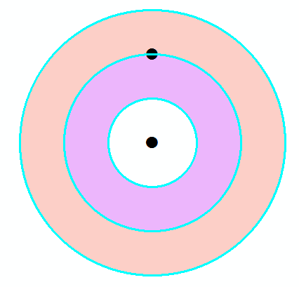
So if you have Multiple Ring Buffer boundaries defined at say 20, 50, and 100 miles, which 'Ring' does a point at exactly 50 miles fall in? Are the boundaries inclusive or exclusive limits? I have scoured the internet for an answer and cannot find a single post that addresses this.
Thanks in advance for your comments.
- Mark as New
- Bookmark
- Subscribe
- Mute
- Subscribe to RSS Feed
- Permalink
most classifications schemes in mathematics (ie random number generation, statistics and in programming languages are.. up to, but not inclusive. I would suggest you check it, but that depends upon how the geometry is represented. A buffer of 1 meter around a point is represented by a n-gon (360 sides generally) so inclusion can fail even if an entity is within the bounds.
If this is a mission critical test, you would be advised to select within some tolerance, then fine-tune your selection with actual euclidean comparisons. (ie 1 +/- 0.001 m, then do the actual math.)
- Mark as New
- Bookmark
- Subscribe
- Mute
- Subscribe to RSS Feed
- Permalink
The boundaries are shared, it's not one or the other. A point on the boundary intersects both buffer geometries.
- Mark as New
- Bookmark
- Subscribe
- Mute
- Subscribe to RSS Feed
- Permalink
The warning being to dissolve the buffers should be given so that the rings are indeed isolated. I would still check using point distance or simple calculation to confirm. In theory there will be duplicate rings then
- Mark as New
- Bookmark
- Subscribe
- Mute
- Subscribe to RSS Feed
- Permalink
This is a simple matter of selecting one of the rings in your output feature class and looking to see if the boundaries are inclusive or exclusive. It actually depends on how you set your parameters. That is--click on the Select Features tool, then click on one of the rings. You will see it highlight so you can see the area it covers.
- Mark as New
- Bookmark
- Subscribe
- Mute
- Subscribe to RSS Feed
- Permalink
Is one wants a mutually exlusive buffer ring (ergo, a classification scheme), you need to do the dissolve the rings since selecting the inner ring will select both rings ie one extending from the center to 100 m and from the center to 200 m. If a true classification scheme for a multi-layers set of rings were implemented the boundary should not be shared otherwise you wouldn't have a a true mutually exclusive classification scheme. selecting the boundary between 0-100 and 100-200 should select one or the other, not both. Otherwise you have a 0-100 and and 0-200 classification scheme, which is valid, but not exclusive
- Mark as New
- Bookmark
- Subscribe
- Mute
- Subscribe to RSS Feed
- Permalink
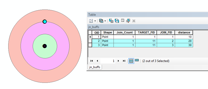
I think I misunderstood your question though. I believe if you did something like a spatial join, your point at 50 miles would create two spatial join records, one for each buffer polygon. That would leave it up to you to filter out your results. The thing that bothers me about this idea is that I have done such a thing many times, and I don't remember any issue with counts not adding up on the borders of buffers. If you have such data handy, it would be a simple thing to test.
- Mark as New
- Bookmark
- Subscribe
- Mute
- Subscribe to RSS Feed
- Permalink
Yes, the point on the boundary creates two spatial join records.
- Mark as New
- Bookmark
- Subscribe
- Mute
- Subscribe to RSS Feed
- Permalink
The more I think about this and remember... Yes, if you do a spatial join with a point on the border of two multi-ring buffers, your results will have records for "hits" with both buffers if you choose the parameter JOIN_ONE_TO_MANY. If you choose the parameter JOIN_ONE_TO_ONE, ArcGIS will rather arbitrarily choose one or the other, and you will only have one record. Is that the sort of thing you are wondering about?
- Mark as New
- Bookmark
- Subscribe
- Mute
- Subscribe to RSS Feed
- Permalink
<beating a dead horse>
I'm guessing you want to make your legend something like the following, as you would do with most numerical classifications:
0 <= x < 20
20 <= x < 50
50 <= x < 100
but as (I think) we've shown, the "truth" with multiple ring buffers would be:
0 <= x <= 20
20 <= x <= 50
50 <= x <= 100
</beating a dead horse>