Turn on suggestions
Auto-suggest helps you quickly narrow down your search results by suggesting possible matches as you type.
Cancel
- Home
- :
- All Communities
- :
- Products
- :
- Geoprocessing
- :
- Geoprocessing Questions
- :
- Re: ArcGIS not creating a buffer around a line
Options
- Subscribe to RSS Feed
- Mark Topic as New
- Mark Topic as Read
- Float this Topic for Current User
- Bookmark
- Subscribe
- Mute
- Printer Friendly Page
ArcGIS not creating a buffer around a line
Subscribe
4044
5
07-19-2011 07:39 AM
07-19-2011
07:39 AM
- Mark as New
- Bookmark
- Subscribe
- Mute
- Subscribe to RSS Feed
- Permalink
I'm trying to create a 150 meter, full, flat buffer around a line, but ArcGIS (both 9.3 and 10.0) does not create the whole buffer every time I run the buffer tool. The buffer tool itself finishes, but it only creates a very small polygon. The line is relatively complex - it was generated using Network Analyst's Create Service Area tool.
The buffer tool successfully creates the buffer when the distance is set to 135 meters, but any distance value larger than 135 fails. The 150 meter distance works fine when the round option is selected. If I make the buffer distance large (300 meters), the buffer is created successfully.
Does anyone have any insights about this problem?
Dave Van Riper, GISP
Minnesota Population Center
University of Minnesota
5 Replies
07-19-2011
10:02 AM
- Mark as New
- Bookmark
- Subscribe
- Mute
- Subscribe to RSS Feed
- Permalink
Can you post your feature class?
Are you running ArcInfo?
Thanks
Are you running ArcInfo?
Thanks
07-20-2011
02:15 AM
- Mark as New
- Bookmark
- Subscribe
- Mute
- Subscribe to RSS Feed
- Permalink
Hey Dave,
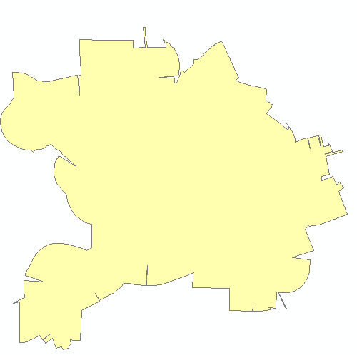
It appears you have a projection problem. If you project your data from NAD_1983_UTM_Zone_15N to WGS1984 it works. The one feature in the southwest might be outside the UTM Zone 15N.
I've attached the image of my output.
To test this, I did the following:
1. Project your attached file to WGS-1984 using the project tool.
2. Using the newly projected data, run the buffer tool to create the buffer.
For testing purposes, I used the following code after I did the projection:
This will loop through all three records and create a buffer for each shape in the LineM feature class.
It appears you have a projection problem. If you project your data from NAD_1983_UTM_Zone_15N to WGS1984 it works. The one feature in the southwest might be outside the UTM Zone 15N.
I've attached the image of my output.
To test this, I did the following:
1. Project your attached file to WGS-1984 using the project tool.
2. Using the newly projected data, run the buffer tool to create the buffer.
For testing purposes, I used the following code after I did the projection:
import arcpy
fc = r"C:\TEMP\scratch.gdb\line1450_proj"
rows = arcpy.SearchCursor(fc)
for row in rows:
    arcpy.Buffer_analysis(row.Shape,
                          arcpy.CreateUniqueName(r"c:\temp\scratch.gdb\buff"),
                          "150 Meters",
                          "#",
                          "FLAT", "ALL"
                          )

del row, rows
print 'finished'
This will loop through all three records and create a buffer for each shape in the LineM feature class.
07-20-2011
04:33 AM
- Mark as New
- Bookmark
- Subscribe
- Mute
- Subscribe to RSS Feed
- Permalink
Thanks, Andrew!
The area of interest is right in the middle of UTM Zone 15, so I'm surprised that was the problem. Also, because the larger and smaller buffer distances worked but not 150 meters.
But, I'll take this solution.
The area of interest is right in the middle of UTM Zone 15, so I'm surprised that was the problem. Also, because the larger and smaller buffer distances worked but not 150 meters.
But, I'll take this solution.
07-20-2011
08:06 AM
- Mark as New
- Bookmark
- Subscribe
- Mute
- Subscribe to RSS Feed
- Permalink
It seems to be a problem with line complexity and the flat option. Generalizing the line makes it work fine. Try finding a level of generalization that will weed out enough verticies to let the tool work without getting confused, but not harm the characterization of the line network.
The line nests that work are both quite angular, with lots of straight lines.
The idea about being ouside the UTM zone is unlikley, unless you are very far outside it: say, the other side of the world (which is infinetly far from the central meridian). UTM zones are 6 degrees wide to keep distortion within 'acceptable' limits, not because they stop at the edge.