- Home
- :
- All Communities
- :
- Global
- :
- Europe
- :
- GeoDev Germany
- :
- GeoDev Germany Blog
- :
- Internet-of-Things: Wie können iBeacons als Sensor...
Internet-of-Things: Wie können iBeacons als Sensor zur Echtzeit-Standortbestimmung und -analyse in Gebäuden eingesetzt werden?
- Subscribe to RSS Feed
- Mark as New
- Mark as Read
- Bookmark
- Subscribe
- Printer Friendly Page
Wherever many people come together, challenges arise. Both in outdoor areas, but especially within buildings, it can quickly "bump" somewhere. This is not uncommon in major events such as concerts or sporting events with several thousand visitors. But even with a few hundred people, the single toilet can be crowded before, or provide a lecture room not enough space for all participants.
Would not it be nice to be able to see live on a map of the building, how crowded a specific place is, if there is still space available, and whether it is worth taking the road at all?
And would not it be nice for the organizer to always have an up-to-date overview of the utilization of individual areas of the building during the event, and perhaps proactively avoid bottlenecks?
Would not it be great if you could use the results of a current event to be better prepared for follow-up events?
This is precisely the question we asked ourselves in advance of this year's Esri Developer Summit in Berlin .
Together with our startup partner, Square Metrics , we have developed a demo scenario in which iBeacons are used to measure the occupancy of specific locations in the building by measuring when and how often a particular beacon is triggered by the approach of a participant becomes.
The (anonymous!) Information sent by each beacon was first sent to the Proximity DMP of Square Metrics, where the individual beacons were registered and organized. From there, every single event was sent in real-time to the ArcGIS backend, where a GeoEvent server received the information, evaluated it in real-time and saved it for later analysis. The following graphic shows an overview of the components used and the interaction between them.
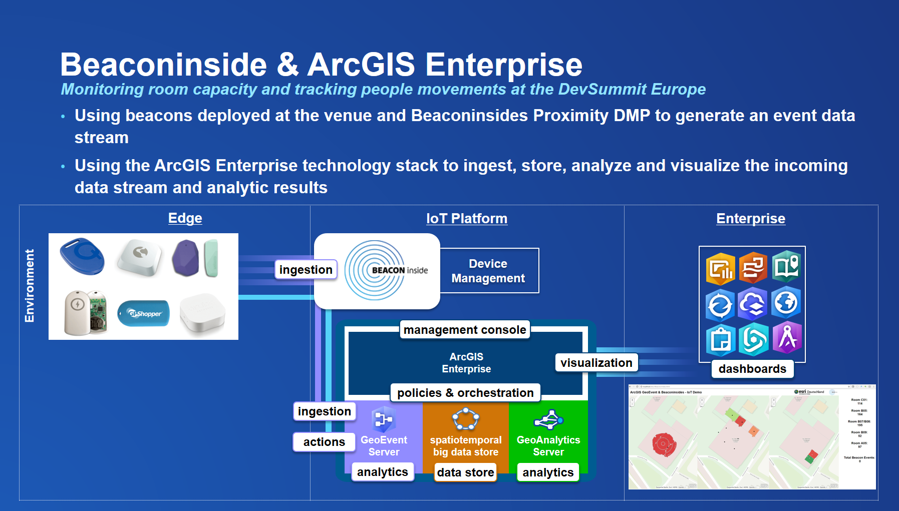
The graph also makes it clear that ArcGIS Enterprise can be upgraded to a full-fledged IoT platform in conjunction with external device management .
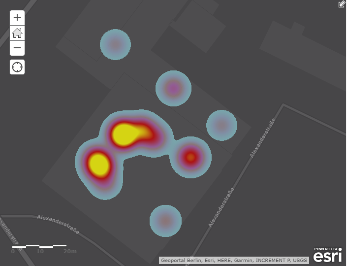
This allowed us to show on a map how many times a particular sensor was triggered, both when entering a certain area and when leaving it. If you now place a beacon in a room, you can quickly calculate how many people went in and out at a certain time. Compared with the actual capacity, one can quickly create an indicator that indicates whether a particular room is overcrowded or whether there are still free seats available.
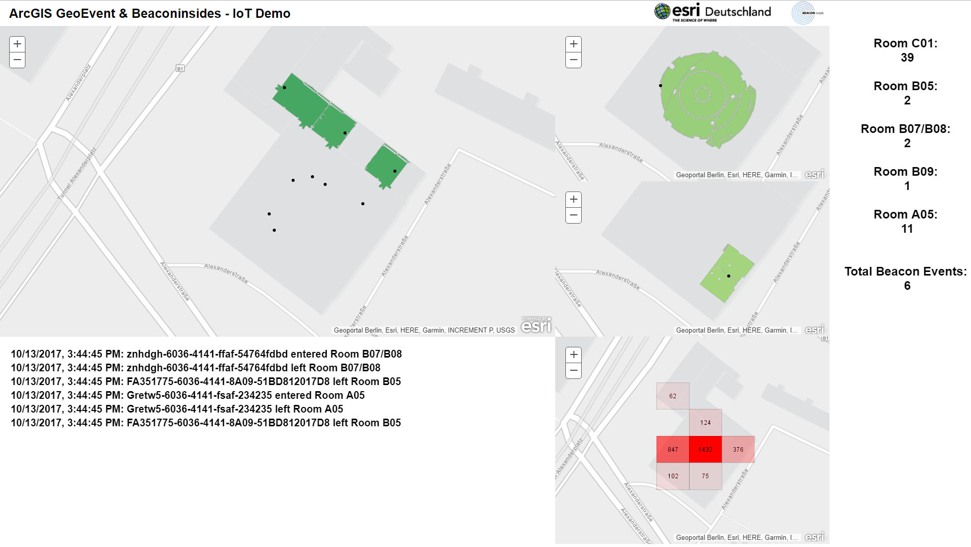
Hotspots and coldspots can be identified quickly and thus conclusions can be drawn as to which lectures are good and which are less well received by the audience.
Taking into account not only a single beacon, but all the sensors distributed in the building, you can even detect motion profiles, for example, whether or not there is a connection between certain places (and content presentations). For example, did a Javascript developer also attend .NET lectures, or was he in the cafeteria at those times?
With all this information, you can react to specific events during the event and then analyze the current event so that the following events are adapted to the behavior of the participants.
No more congestion in front of the toilet, always a free seat in the lecture - it does not have to remain a utopia: with iBeacons and ArcGIS as a real-time IoT platform!
You must be a registered user to add a comment. If you've already registered, sign in. Otherwise, register and sign in.