- Home
- :
- All Communities
- :
- Industries
- :
- Gas and Pipeline
- :
- Gas and Pipeline Questions
- :
- Re: Esri Utility Network Configuration and Data Lo...
- Subscribe to RSS Feed
- Mark Topic as New
- Mark Topic as Read
- Float this Topic for Current User
- Bookmark
- Subscribe
- Mute
- Printer Friendly Page
Esri Utility Network Configuration and Data Loading Tools Status
- Mark as New
- Bookmark
- Subscribe
- Mute
- Subscribe to RSS Feed
- Permalink
Network Configuration Data Model Version Last Update Configuration Location Data Loading Tools Location Migration Tools Location
| Electric (Distribution & Transmission) | 4.0 | May 2021 | http://esriurl.com/elecmigration | ||
| Communications | 1.1 | May 2021 | https://solutions.arcgis.com/shared/help/data-loading/ | - | |
| Gas / Hazardous Liquid Pipeline (UPDM) | 1.2 | May 2021 | - | ||
| Sewer | 4.0 | May 2021 | http://esriurl.com/sewerunconfig | https://solutions.arcgis.com/shared/help/data-loading/ | - |
| Stormwater | 4.0 | May 2021 | http://esriurl.com/stormwaterunconfig | https://solutions.arcgis.com/shared/help/data-loading/ | - |
| Water Distribution | 4.1 | May 2021 |
This table shows the current status of Utility Network Industry Configurations and data loading tools. It will be kept up to date.
Resource specific data models for the utility network are contained in the corresponding Network Configuration. For example, if looking for the water distribution data model for the utility network download the Water Distribution Data Management for ArcGIS Enterprise.
- Mark as New
- Bookmark
- Subscribe
- Mute
- Subscribe to RSS Feed
- Permalink
UPDM and the Gas Pipe Utility network configuration was made with material as the Asset Types to build rules to control which types of pipes, fittings, etc can be connected. Do you not require rules by material in your implementation?
- Mark as New
- Bookmark
- Subscribe
- Mute
- Subscribe to RSS Feed
- Permalink
Hi Mike,
besides cathodic protection I don't see a benefit for connectivity but we all have CP so maybe good to have the material in. Just strange that water and gas see in differently.
- Mark as New
- Bookmark
- Subscribe
- Mute
- Subscribe to RSS Feed
- Permalink
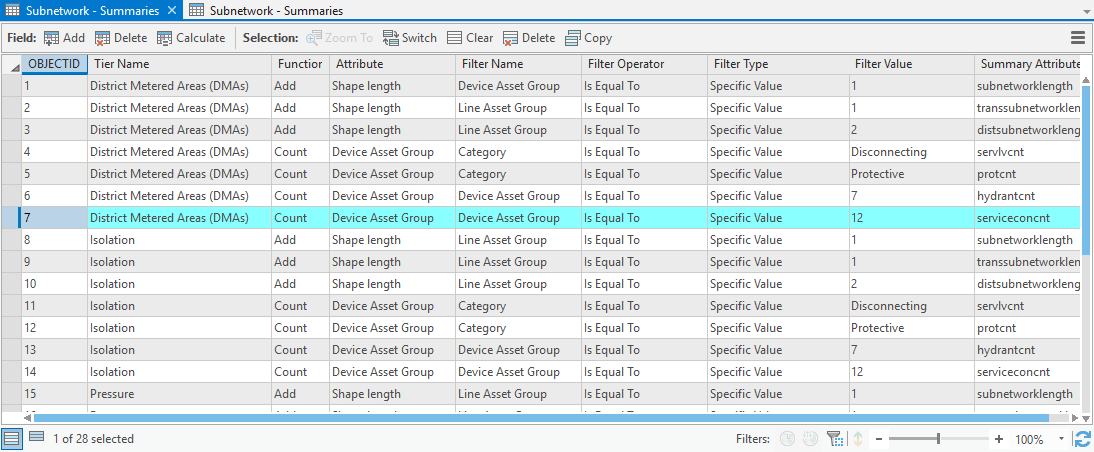
I'm not sure if this is the most effective place to mention this, but we've spotted a glitch in the latest water distribution asset package (3.2) - it is designed to report the "service connection count" per subnetwork but isn't correctly configured to do so within most of its tiers. It turns out to be quite easy to fix - by editingthe relevant records in the "B_Subnetwork_Summaries" table of the package GDB before applying it to the enterprise GDB.
- Mark as New
- Bookmark
- Subscribe
- Mute
- Subscribe to RSS Feed
- Permalink
Hi Andrew,
Thank you for letting us know! I have updated the summaries table for version 3.3 that will release in January.
- Mark as New
- Bookmark
- Subscribe
- Mute
- Subscribe to RSS Feed
- Permalink
Similarly, the transsubnetworklength and distsubnetworklength summary attributes should be based on the summed lengths of lines with an asset type of 1 and 2 (respectively) - rather than asset groups 1 and 2.
This can be fixed in an existing utility network (with topology disabled) by running Add Network Attribute, Set Network Attribute, and Set Subnetwork Definition.
- Mark as New
- Bookmark
- Subscribe
- Mute
- Subscribe to RSS Feed
- Permalink
Hi All,
Is there a way to incorporate cardinality rules in the utility network that define how many edges can be connected to a single device/junction. An example of this would be limiting the maximum number of edges that can connect to a X-Junction (cross junction) to 4.
Thanks everyone!
- Mark as New
- Bookmark
- Subscribe
- Mute
- Subscribe to RSS Feed
- Permalink
The Utility Network does not model cardinality, but it can be enforced, restricted or flaged as error with an Attribute Rule. Here is an example of a constraint rule I created to reject too many related features by type. This could also be done as a validation rule where instead of preventing the edit, it would just mark the issue as an error when the rule was violated.
https://github.com/MikeMillerGIS/arcade-expressions/blob/master/attribute_rule_constraint/reject_too_many_related.md
- Mark as New
- Bookmark
- Subscribe
- Mute
- Subscribe to RSS Feed
- Permalink
Michael,
Thank you for the link to the item within your git repo. The other rules in this repo are very interesting and will definitely be looking into some of these in the future.
Just a quick question - How much overhead to the user do these cause? Especially when it comes to looking up values from other feature classes (eg. restrict editing rule looking up the user access from the fgdb)? Is the delay noticeable everything it fires on the insert/update/delete?
Thanks
- Mark as New
- Bookmark
- Subscribe
- Mute
- Subscribe to RSS Feed
- Permalink
I am not sure, but the editors should not notice this as it is done in the database.
- Mark as New
- Bookmark
- Subscribe
- Mute
- Subscribe to RSS Feed
- Permalink
The link to the sewer configuration appears to be broken. Ideally, I'm looking for an FME workbench for sewer if that exists...