- Home
- :
- All Communities
- :
- Industries
- :
- Gas and Pipeline
- :
- Gas and Pipeline Blog
- :
- Tracking and Traceability 2020 - Validations
- Subscribe to RSS Feed
- Mark as New
- Mark as Read
- Bookmark
- Subscribe
- Printer Friendly Page
By Tom DeWitte and Tom Coolidge
Installing the correct components when constructing a new pipe system or replacing an existing portion of a pipe system is critical to the safety and reliability of the overall pipe system. When dealing with buried pipe utilities such as natural gas, water, district heating, district cooling, and hazardous liquids, this is a real issue. Every year field crews inadvertently make the following mistakes:
-install polyethylene assets that have been sitting in the service yard for too long
-contractor installed a component for a utility company that is not on the utility companies’ approved manufacturer list
-field crew installed a pipe system component which is no longer compatible with company standards.
Without real-time field validation, these honest mistakes typically do not get identified until after the construction is complete and the pipe components have been covered over. This latency in identification leads to expensive post-construction repairs.
Real-time Validation
If the field construction crews could be notified that a specific pipe component about to be installed does not meet the requirements for valid installation, the previously listed issues could be eliminated. What field crews need is real-time validation.
Configuring Collector for Real-time Validation
In early 2019 Collector for ArcGIS was enhanced to support arcade scripting in the web maps which provide the configuration of Collector’s behavior. As noted in previous blog articles, this opened the capability for real-time decoding of a pipe component’s barcode.
-Tracking and Traceability 2019: Part 1
-Tracking and Traceability 2019: Part 2
The ability to add arcade scripts to the web map pop-up provides an advanced configuration ability to provide field crews with real-time validation.
What’s a field person to do?
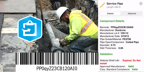
A field person can easily use this real-time validation capability. Since Collector runs on Apple, Android and Windows mobile devices, they could check the validity of pipe segments, plastic device and plastic fittings while unloading them from the delivery truck. All the field person would have to do is to use their smart phone running the Collector to scan the barcode using the device’s camera.
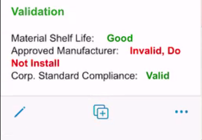
Screenshot of portion of Collector pop-up
Collector will automatically decode the barcode information and open a pop-up window with the validation results. Invalid pipe segments, devices and fittings never reach the installation trench.
Keeping invalid pipe components out of installation trenches improves safety, system reliability, and eliminates unwanted costs. No one wants to have to re-dig the construction location to remove the invalid pipe components.
How is this possible?
Esri makes real-time validation possible by allowing arcade scripts to be added to the web map configuration file. More specifically the arcade script is added to the pop-up configuration in the web map of the pipe, device or fitting layer.
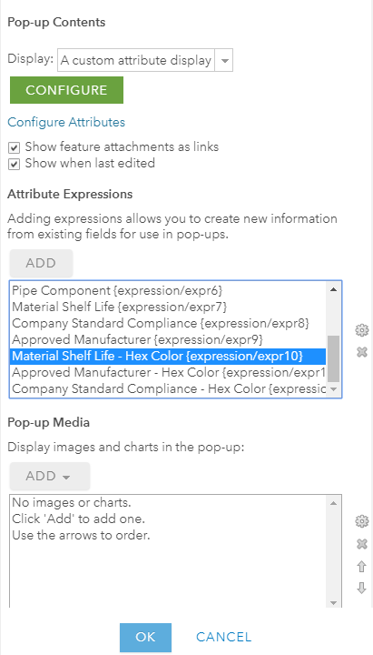
Screenshot of portion of pop-up layer configuration
With the arcade script added to the desired layer pop-ups, the web map is now ready for real-time validation. For the field user, initiation of the validation process occurs automatically when the field user presses the “Submit” button in the upper right corner of the Collector display.

Screenshot of top portion of Collector application
The pressing of the “Submit” button after collecting some information such as scanning of a barcode also automatically opens the pop-up to show the validation results. It really is that easy to deploy and that seamless an experience for the field user.
What is the script doing?
The logic in the arcade script is the key to enabling Collector to perform real-time validation. What must the script do?
The simple answer is that it must be able to acquire the information needed to answer a question. For example, a core validation for plastic pipe construction is whether the polyethylene plastic material is too old. Polyethylene plastic is susceptible to the suns UV rays. Let a roll of medium density polyethylene pipe site in the service yard for over 3 years and the sun’s UV rays will have degraded the material to the point where it should not be installed. The information needed to assess whether the role of pipe is too old is the date of manufacture and the current date. The date of manufacture is acquired form the scanning and decoding of the ASTM F2897 barcode. The current date is acquired from the mobile device itself. Subtract the manufacture date from the current date and you have a time difference. If the time difference exceeds the industry recommended shelf life then that roll of pipe is invalid and should not be installed.
Here is a snippet of the arcade script to determine whether the polyethylene plastic pipe or component has exceeded the recommended shelf life.

Portion of arcade script to determine material shelf life
Where can I get these scripts?
Many people have told me that they find it easier to modify someone else’s script than to write one from scratch. With that statement in mind we have written arcade scripts against a UPDM 2019 data model and the ASTM F2897 barcode standard to address three validation scenarios.
- Scenario 1: Material for HDPE and MDPE has exceeded its shelf life
- Scenario 2: The manufacturer of the pipe system component is not on the utilities approved list.
- Scenario 3: The specific size and model of the component is not part of the utilities set of codes and standards.
These arcade scripts are available for download from the following location on geonet. https://community.esri.com/docs/DOC-14615-tracking-and-traceability-2020-scripts In addition to the scripts are detailed instructions on how to configure and deploy the scripts into your ArcGIS Enterprise or Online organization. That’s right, web map based arcade scripts not only work for ArcGIS Enterprise environments they also work for ArcGIS Online organizations.
What else can Collector real-time validations do
In addition to the real-time validation scenarios previously listed, there are other opportunities for applying real-time validation. For example, you could create custom barcodes for welding and plastic fusion operators. The custom barcodes could embed the worker’s operator qualifications. A Collector web map embedded arcade script could decode that scanned operator’s badge barcode and immediately determine whether the operator is qualified and whether the qualifications are still valid.
The advanced configuration capabilities of web maps with arcade scripting open capabilities that previously required complex and expensive customization. The universal use of web maps in web applications and mobile applications such as Collector allow this configuration to be done once and utilized across Windows mobile devices, Android mobile devices, Apple mobile devices, and web applications.
And did I mention that these real-time validations work even when the device is disconnected from the network?
PLEASE NOTE: The postings on this site are our own and don’t necessarily represent Esri’s position, strategies, or opinions.
You must be a registered user to add a comment. If you've already registered, sign in. Otherwise, register and sign in.