- Home
- :
- All Communities
- :
- User Groups
- :
- Elevation Data
- :
- Questions
- :
- How to Extract Height in meter using DSM?
- Subscribe to RSS Feed
- Mark Topic as New
- Mark Topic as Read
- Float this Topic for Current User
- Bookmark
- Subscribe
- Mute
- Printer Friendly Page
How to Extract Height in meter using DSM?
- Mark as New
- Bookmark
- Subscribe
- Mute
- Subscribe to RSS Feed
- Permalink
I want to get the height information for a particular area in meters.
I have orthomosaic, DSM and DTM of that area
I don't know how to get building height information that too particularly in meters.
I would be thankful to you for this help.
- Mark as New
- Bookmark
- Subscribe
- Mute
- Subscribe to RSS Feed
- Permalink
Aren't the pixel values of DSM and DTM the Elevation values in Meters?
If the values are in Meters, use Raster Calculator to get the difference of DSM and DTM as follows
"DSM_Raster" - "DTM_Raster"
If the inputs are Floating-point Rasters, then use the following expression
Float("DSM_Raster" - "DTM_Raster")
If you overlay the imagery on top of the the above resulting raster, the pixel values of the resulting DEM should give you the height of building in Meters. Results would be more accurate if the DSM and DTM are floating-point rasters.
Think Location
- Mark as New
- Bookmark
- Subscribe
- Mute
- Subscribe to RSS Feed
- Permalink
I really appriate your help but could you please help me out regarding how to extract height using DSM as I am a bit new to Arcmap.
- Mark as New
- Bookmark
- Subscribe
- Mute
- Subscribe to RSS Feed
- Permalink
I have orthomosaic, DSM and DTM of that area
Considering you have all the above Rasters, did you get any error running Raster Calculator as I mentioned in my above comment?
Think Location
- Mark as New
- Bookmark
- Subscribe
- Mute
- Subscribe to RSS Feed
- Permalink
Actually I don't know how to use raster calculator.
Can we derive the height only using DSM or we need both DTM and DSM????
- Mark as New
- Bookmark
- Subscribe
- Mute
- Subscribe to RSS Feed
- Permalink
have your raster layers in your data frame, launch the raster calculator.
In the picture in the link it shows how to add three rasters together.
subtraction is the same principle
double-click on the raster names and sincle click on the operator ( -) . Just get the rasters in the right order
- Mark as New
- Bookmark
- Subscribe
- Mute
- Subscribe to RSS Feed
- Permalink
Sir, I got what your are saying and I really really appreciate your help.
What I am not getting is not regarding how to subtract 2 raster. The thing what I wanted to know is how to get the elevation data i.e. height of particular area that too particularly in meter.
I mean weather we need a DSM for it or a DTM or both or what?????
- Mark as New
- Bookmark
- Subscribe
- Mute
- Subscribe to RSS Feed
- Permalink
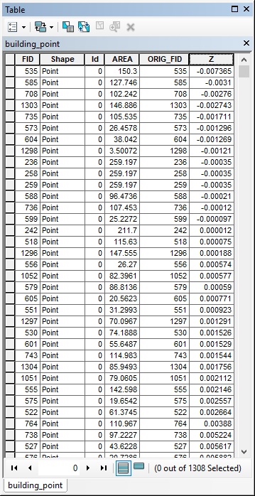
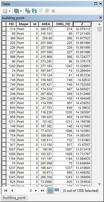
Above is the attribute table of points which I generated as a result of the tool "Add Surface Information".
The raster I used in the tool "Add Surface Information" was the raster being generated as a result of output of raster calculator i.e. DSM - DTM.
Now what is this Z value. Is this the height of building. If Yes what is the unit of this. I am really very very confused as this is the first time I am doing this. By the way thanks a lot in advance.
- Mark as New
- Bookmark
- Subscribe
- Mute
- Subscribe to RSS Feed
- Permalink
The values of Building heights look too low to be true (Some have negative values as well).
Are you sure one of the rasters is actually a DTM?
What is the cell-size of the DSM, DTM and the Difference rasters?
Also could you provide the Min-Max values of DSM and DTM rasters?
It looks like you have sorted the records in ascending order of the Z-value. What values do you see when you sort it in descending order?
Think Location
- Mark as New
- Bookmark
- Subscribe
- Mute
- Subscribe to RSS Feed
- Permalink
BELOW IS THE LIST OF ANSWERS TO YOUR QUESTIONS:
Question 1: Are you sure one of the rasters is actually a DTM?
Answer 1: Yes sir, I have generated DSM and DTM both as a result of drone2map i.e. by processing of drone images.
Question 2: What is the cell-size of the DSM, DTM and the Difference rasters?
Answer 2: Attached below is the image which shows cell size of DSM as (0.02421, 0.02421), DTM as (0.12104, 0.12104) and the difference raster as (0.12104, 0.12104).
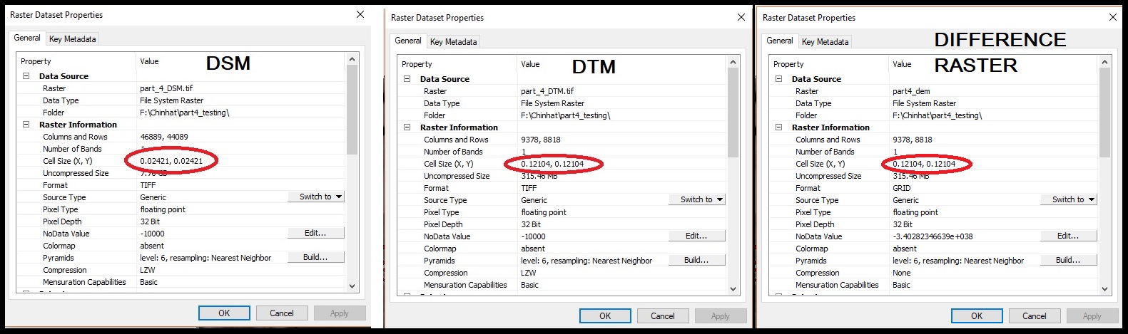
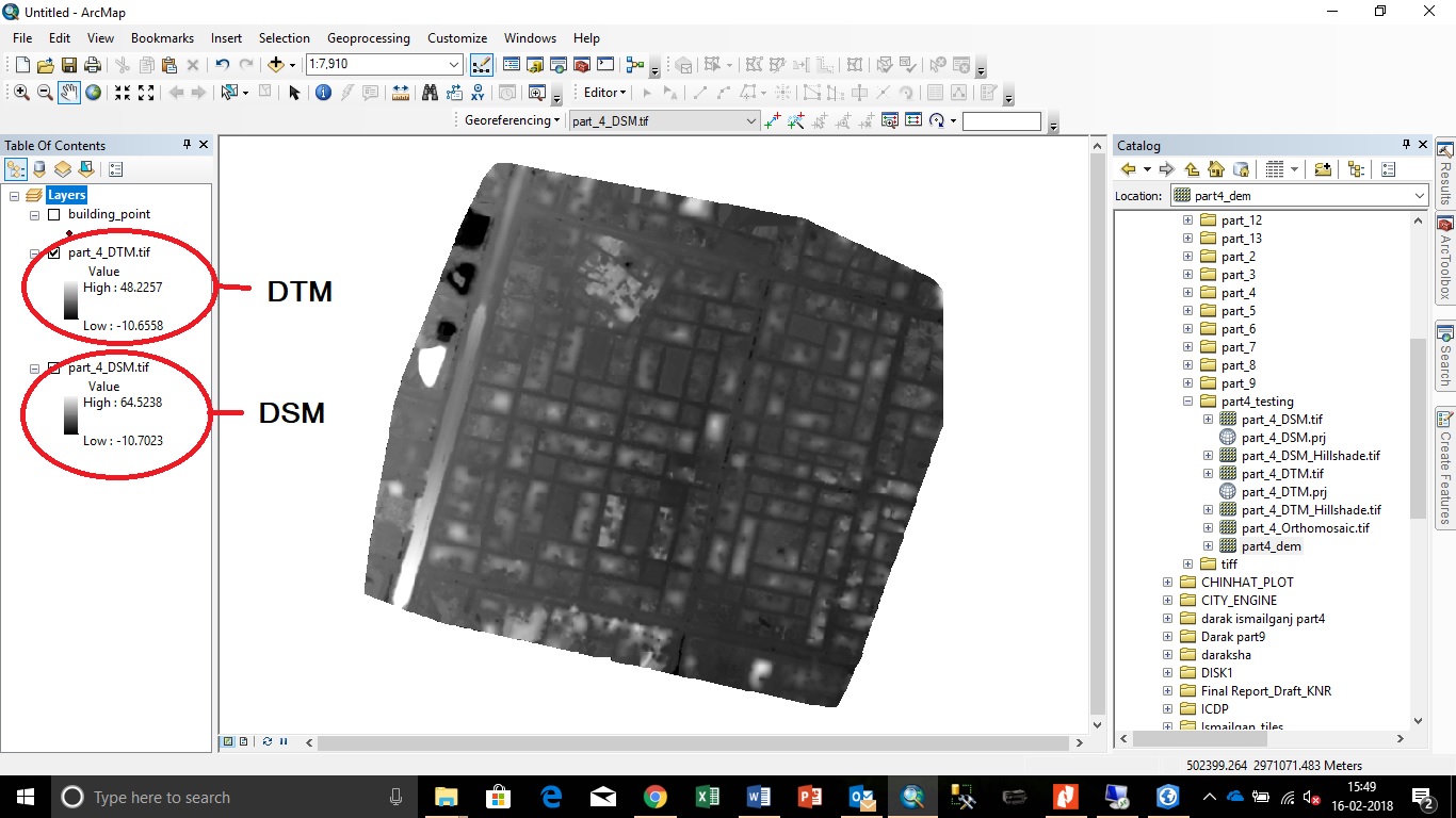
Question 3: Also could you provide the Min-Max values of DSM and DTM raster?
Answer 3 : DSM (Min. = -10.7023 and Max = 64.5238)
DTM (Min. = -10.6558 and Max = 48.2257)
The minimum and maximum values can also be confirmed as per the screenshot below:
Question 4: It looks like you have sorted the records in ascending order of the Z-value. What values do you see when you sort it in descending order?
Answer 4: Attached below is the image which shows values sorted in descending order of Z value.