- Home
- :
- All Communities
- :
- Industries
- :
- Electric
- :
- Electric Questions
- :
- Re: Dirty area measurement of use
- Subscribe to RSS Feed
- Mark Topic as New
- Mark Topic as Read
- Float this Topic for Current User
- Bookmark
- Subscribe
- Mute
- Printer Friendly Page
- Mark as New
- Bookmark
- Subscribe
- Mute
- Subscribe to RSS Feed
- Permalink
From the images relating to the Utility Network - Dirty Area of point features, what unit of measure is used with the buffer distance to create the polygons?
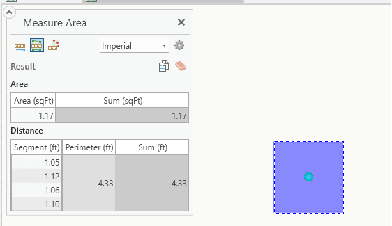
It appears the buffer distance is always 0.5 so the diameter/perimeter distance is 1 and the unit of measure is based on the reference coordinate system of the utility network service/datasource.
In the Naperville Demo data, the reference coordinate system of the data/service is projected of feet (NAD 1983 StatePlane Illinois East FIPS 1201) and the resulting dirty area is 1ft perimeter.
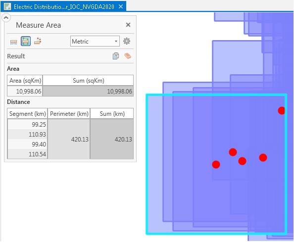
We have developed a PoC with data in Geocentric Datum Australia 2020 (GDA2020) which is geographic in decimal degrees. 1degree in distance is approx. 101-111km depending if relates to Latitude or Longitude. As you can see, the perimeter distance is approx. 100-110kms which is a consistent methodology to the 1feet example with the Naperville data.
Also, can it be confirmed this resulting buffer is passed to a minimum bounding box function to produce the rectangle as the buffer on points creates circles?
Paul LeBlanc is this related to the projection issue mentioned in Applying WaterDistribution_AssetPackage fails or related to Apply Asset Package error - Get attribute metersPerUnit does not exist
Solved! Go to Solution.
Accepted Solutions
- Mark as New
- Bookmark
- Subscribe
- Mute
- Subscribe to RSS Feed
- Permalink
Those issues with the asset package were related to GCS. Regardless of how you create your UN, the default dirty area size is based on the units of the spatial reference of your feature dataset.
Roughly yes, it's buffering the point by half the defined unit of the spatial reference. There's some extra tolerance that's added, so it's bigger than the circle's MBR.
- Mark as New
- Bookmark
- Subscribe
- Mute
- Subscribe to RSS Feed
- Permalink
Thanks Paul. You stated the "the default dirty area size ...". Does this mean there is a configuration somewhere that can be updated?
- Mark as New
- Bookmark
- Subscribe
- Mute
- Subscribe to RSS Feed
- Permalink
At this time there isn't a mechanism to update the default dirty area size.
- Mark as New
- Bookmark
- Subscribe
- Mute
- Subscribe to RSS Feed
- Permalink
Hi Paul,
I have attempted to change the coordinate system of Naperville to Geographic (GDA2020) via "Change Asset Package Spatial Reference" and then re-appending all the network data, so everything including the Feature Layer is geographic. The Apply Asset Package through to Share Web Layer all went fine. The feature layer looks good too as far as having all the layers expected including Point/Line/Polygon Errors and Dirty areas. When I add this feature layer to ArcGIS Pro 2.4.2 I get all the layers except for Point/Line/Polygon Errors and Dirty areas although I can view the Dirty areas via a map service. Dirty areas are small, unlike the issue that Damian Pyne found where his map units were in degrees, so I am unsure how to replicate the issue where the default dirty area size is huge. The reason why I am going through this process is to upgrade and test ArcGIS Pro 2.5 beta, have you any idea what I may have missed regarding replicating this issue? When I upgrade is there a setting in ArcGIS Pro 2.5 beta where I can set the default dirty area size, if so where would I find it?
Thanks Will
Esri Australia Professional Services.
PS This is the enhancement I want to test in ArcGIS Pro 2.5 ENH-000123974 "Provide the ability to configure the dirty area buffer distance default calculation for a Utility Network"
- Mark as New
- Bookmark
- Subscribe
- Mute
- Subscribe to RSS Feed
- Permalink
Will,
Are you looking at the dirty areas that already exist in the sample data or are you looking at new dirty areas that you have created by placing new features?
- Mark as New
- Bookmark
- Subscribe
- Mute
- Subscribe to RSS Feed
- Permalink
Hi Anthony,
These are completely new dirty areas, created by both modifying an existing feature and adding a new one.
It seems we went through the same process of having to append the Naperville feature classes after "Change Asset Package Spatial Reference" truncated all the asset feature classes, just not sure why I am getting Minimum Bounding Rectangle dirty areas when you were getting ones so much larger. Once Paul lets me know where to find this setting in ArcGIS Pro 2.5 I will upgrade to the Beta and retest.
- Mark as New
- Bookmark
- Subscribe
- Mute
- Subscribe to RSS Feed
- Permalink
Will although you have re-projected the asset package, you need to also re-project the data, and the service territory.
In the scenario you are referring to, I projected the AP to GDA2020, the data was transformed from GDA1994 MGA 56 to GDA2020 and the service territory was based on GDA2020. In the data I loaded, I had created some errors for testing, and additionally created new features for dirty area tests.
- Mark as New
- Bookmark
- Subscribe
- Mute
- Subscribe to RSS Feed
- Permalink
I wanted to contact you because I was looking into your inquiry on the following enhancement:
ENH-000123974 "Provide the ability to configure the dirty area buffer distance default calculation for a Utility Network"
This was incorrectly linked to the internal dev issue that was resolved for 2.5 regarding dirty area size for GCS. However the feature/enhancement for the ability to configure the dirty area size generated is still under consideration for a future release. I'll get this corrected in the system and sorry for this confusion.
- Mark as New
- Bookmark
- Subscribe
- Mute
- Subscribe to RSS Feed
- Permalink
Thanks for the update Melissa, I notice that ENH-000123974 has changed it status back to "In product plan". May we have some more information about the "internal dev issue that was resolved for 2.5 regarding dirty area size for GCS"? I am wondering if this resolution is why I could not replicate the large dirty areas in a completely new geographic enterprise database from a converted Naperville asset package.