Stop Teaching GIS
- Subscribe to RSS Feed
- Mark as New
- Mark as Read
- Bookmark
- Subscribe
- Printer Friendly Page
Teach how to learn GIS instead.
That was a guiding principle as I recently redesigned the gateway course to the Penn State Online certificate and masters degree programs in GIS.
I began developing "Nature of Geographic Information" in 1998, at the outset of the Penn State Online program. I designed the course to serve adult students who sought to start or advance careers using GIS. The online course consisted of an open-access textbook (http://natureofgeoinfo.org) and associated courseware for registered students. The courseware included ungraded and graded quizzes meant to ensure students' engagement with the text, as well as discussion forums and prescribed projects that required students to practice working with, and writing about, key concepts and technologies.
Over 10,000 students have taken the course through the years, and most have expressed satisfaction with their experiences. Penn State colleagues and students helped me update the course incrementally. But the geospatial field has changed fundamentally since the late 1990s, and the Penn State Online program that the course was designed to introduce has evolved and expanded along with it. Equally important, our understanding of how people learn (and in particular, how they learn online) has advanced considerably. Nearly 20 years on, "Nature of Geographic Information" was overdue for a complete makeover.
Although I began working with Esri full-time in 2011, I continued to lead online classes and workshops part-time for Penn State. I was thrilled and a bit overawed when program director Anthony Robinson invited me to create and lead a new version of the course. I accepted the challenge in the summer of 2016, and worked on the revision for over a year. The result, now known as "Making Maps that Matter with GIS," differs from its predecessor in scope, objectives, content, and user experience. Regarding content, the main difference is that I stopped assigning a textbook (though several texts are suggested options). It seems to me that today's next-generation GIS text is the World Wide Web itself.
The user experience in the new course is markedly different as well – for instructors as well as students. As the syllabus states, "students are expected to investigate assigned topics independently and to share findings within study groups to collaboratively construct understandings of these topics." The course introduction goes on to state that “The best employers in this field are looking for GIS pros who know how to discover, evaluate, and use information needed for the task at hand. This course is designed to help you strengthen those skills. The course establishes educational objectives, but does not spoon-feed the information needed to achieve them. We expect you to find and discuss the required information yourself, using the web, libraries, and your own personal experience." Instructors spend considerably more time evaluating student discussion posts and web mapping projects using rubrics like the one illustrated here, and proportionately less time updating exercise instructions and other course content.
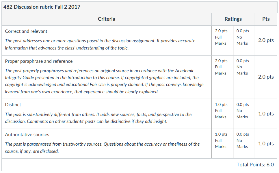
Rubric used to score students’ contributions to discussions in Penn State’s GEOG 482: Making Maps that Matter with GIS.
The notion that people learn best when they actively construct knowledge in relation to what they already know is not a new idea, of course. Neither am I alone in believing that students - particularly adult students - should be challenged to take more responsibility for their own learning. For example, Karen Kemp, Professor of Practice at the University of Southern California and co-editor of the original NCGIA Core Curriculum in GIS, says "my goal in teaching now in our field is simply to teach students how to learn." Don Boyes of the University of Toronto reports that "Where it makes sense, I am encouraging students to learn how to find their own data … I provide some guidance about where to look for data and how to evaluate it, but I want them to be in charge of their own work as much as possible. " At Minnesota State University Moorhead, David Kramar “generally begin the semester with some cookbook/step-by-step exercises that are intended to get the students familiar with the software interface and basic functionality. However, my ‘true’ labs require them to think critically, use the help and search functionality, and (frankly) figure it out for themselves (with my guidance and assistance as needed).”And in their 2017 International Journal of Geographical Information Science article "Critical GIS pedagogies beyond 'Week 10: Ethics", Sarah Elwood of the University of Washington and Matthew Wilson at the University of Kentucky state that "our approach to skill-building now involves students in learning new interfaces or platforms through individual and collaborative exploration without detailed step-by-step instructions, but with instructions for how to identify and productively engage online user forums, help files, etc."
There are many ways to get students more actively involved in learning. The right strategy depends on your educational objectives, your students’ ages and experience, and your instructional context. For instance, Robert Rose at the College of William and Mary directs a support unit that offers GIS classes to students in Geology, Environmental Studies, Government, and other undergraduate programs. They’ve adopted a "laddered approach" to GIS instruction that begins with scripted GIS activities, followed by "add-on" exercises with less detailed guidance, culminating in a final project in which students create “habitat suitability models for mythical beasts” with no step-by-step instructions. At San Diego Mesa College, Michele Kinzel uses “backwards design and constructivist approaches. I also reach out to multiple learning styles and combine individual hands-on GIS lessons with small group work and other types of exploration.” Boris Mericskay at Université Rennes2 developed an “inverted approach” in which he “poses a problem to students and leaves it to them to find the right tools and how to combine them.” “At the beginning the students are a little lost,” Boris admits, “but eventually they figure out how to apply GIS to solve the problem I posed.” Like Don Boyes and others, Bob Kolvoord of James Madison University has taken a “flipped classroom” approach, in which “students have various work they need to do to prepare for class and then class time is spent working on largely open-ended exercises to bolster their spatial thinking and GIS skills.” Some strategies involve more elaborate educational technology than others: Geographer Ashley Ward and GIS Librarian Amanda Henley at the University of North Carolina Chapel Hill challenge small groups of students to select 8-10 socioeconomic variables from the Atlas of Human Development in Brazil, map the variables using ArcGIS Online, and then, prompted by patterns they discover in the maps, embark on self-guided explorations of on-ground landscapes using Google StreetView in a Liquid Galaxy immersive virtual reality display.
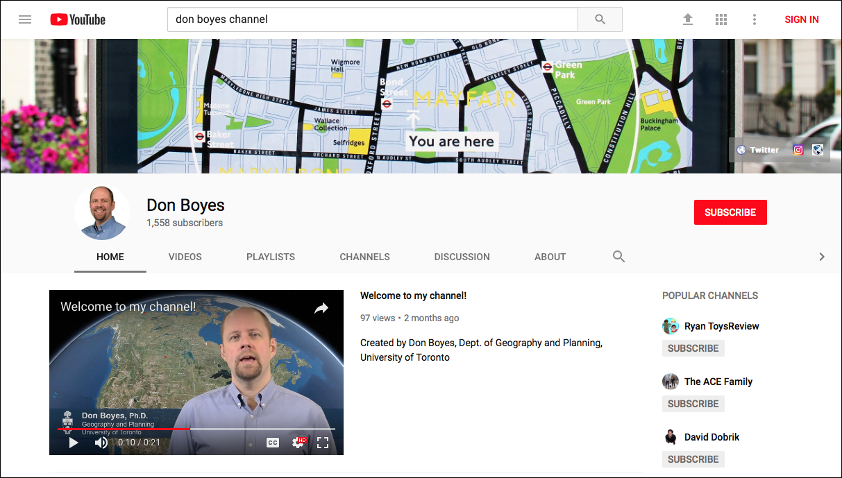
Don Boyes’s YouTube channel, where he shares self-produced video demonstrations to support his “flipped classroom” approach.
Requiring students to take greater responsibility for their learning isn’t easy, and it’s not for everyone. Vince DiNoto of Jefferson Community and Technical College in Louisville, Kentucky says that while he’s a "firm believer in less lecturing and more personal assistance,” he finds that “students directly out of high school really struggle with open ended case studies. They email me constantly, imploring me to tell them what I want.” Aaron Addison of Washington University in St. Louis reports that “I’ve tried the ‘guide on the side’ rather than ‘sage on the stage’ approach at the graduate student level, and to a lesser extent at the undergraduate level. My experience (unfortunately) is that it may work on a 1:1 basis, but does not appear to result in successful outcomes in a classroom setting with 15-20 students.” Bob Kolvoord relates that “on the whole, the flipped classroom approach works well, but it can be a challenge for students who aren’t motivated or that have poor task/time management skills.”
What about the students in my new course? A formal evaluation of student outcomes and preferences is underway, but anecdotal data is the best I have to share at this point. I found feedback from one student – an accomplished young woman who is new to GIS but previously earned a PhD in Marine Geochemistry – particularly enlightening. Early in the first offering of the course, she wrote me privately to express frustration. She wrote, "I (and probably most students) signed up to learn from an expert (and you are, according to your credentials, an expert!). But in the discussion forums, we’re learning from our peers, and most of us are hardly experts." She felt cheated. Rather than waiting to submit an anonymous evaluation at the end of the course, she asked permission to create a forum in which students could share critiques and suggestions about the course. Later in the course I took her advice, and invited all 53 students to post in a Course Commentary discussion. By this time, students had about six weeks of experience with the new course format. On reflection, the same student wrote this:
… after my first exchange with David a few weeks back about my frustrations with this class … I dug up an interesting article in Harvard Magazine1 about how interactive learning is much more successful than traditional (lecture) teaching and learning methods, although it meets with a lot of resistance. I was skeptical then, but the more time passes, the more I find this active learning class engaging, the more I enjoy what I’m learning, and the more I agree that, overall, this pedagogical method has been a success with me.
Other students complained that researching unfamiliar topics independently, and reading their peers’ many posts, was too time-consuming. Fellow instructor Adrienne Goldsberry and I streamlined that aspect of the course for the second offering, and fewer complaints about excessive workloads followed. However, it remains true that students who are unfamiliar with the subject matter, or who prefer their accustomed roles as consumers of instructor-produced content, are uncomfortable with the level of responsibility that the course demands.
At this point it should be clear that the call to action in the title of this short article is purposefully provocative. Naturally, every college and university educator wants to help students learn to discover, evaluate, apply, and share knowledge independently and in groups. Even so, I believe it’s healthy for GIS educators to ask ourselves frankly whether we give our students enough responsibility for their own learning. The question and answer has been transformative for me.
1 Lambert, Craig (2012). Twilight of the Lecture. Harvard Magazine https://harvardmagazine.com/2012/03/twilight-of-the-lecture
You must be a registered user to add a comment. If you've already registered, sign in. Otherwise, register and sign in.
-
Administration
90 -
Announcements
88 -
Career & Tech Ed
1 -
Curriculum-Learning Resources
286 -
Education Facilities
24 -
Events
77 -
GeoInquiries
1 -
Higher Education
618 -
Informal Education
286 -
Licensing Best Practices
102 -
National Geographic MapMaker
43 -
Pedagogy and Education Theory
241 -
Schools (K - 12)
282 -
Schools (K-12)
308 -
Spatial data
39 -
STEM
3 -
Students - Higher Education
259 -
Students - K-12 Schools
147 -
Success Stories
44 -
TeacherDesk
1 -
Tech Tips
129
- « Previous
- Next »