- Home
- :
- All Communities
- :
- Industries
- :
- Education
- :
- Education Blog
- :
- Fun with GIS 203: Index Grids Rule
Fun with GIS 203: Index Grids Rule
- Subscribe to RSS Feed
- Mark as New
- Mark as Read
- Bookmark
- Subscribe
- Printer Friendly Page
Think back to your early map reading days. Do you remember using an index or reference grid — rows and columns of letters and numbers — to find a zone in which to look for something? These grids are really helpful for many learners and many purposes. Now there is an app (still beta, but robust) with which to generate such grids as needed.
It’s simple. Log in to the app with your ArcGIS Online credentials (publishing privileges are required), pan and zoom to the region of interest, set the desired number of rows and columns, click a button and drag a box, and a graphic grid appears. If you don’t like it, just hit the trash button and try it again. When happy, click the button, and the system generates a feature layer in your contents for you. It works at all scales I’ve wanted to try — from a parking lot to a continent. (Naturally, local level minimizes issues of cartographic distortion.)
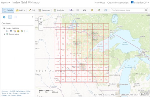
Some educators have wanted a grid atop a portion of their school grounds in order to assign data collection tasks, or even to reference player positions on an athletic field. Others have wanted a grid atop a state map to support teaching about features and locations. The grids can be generated quickly for ad hoc processes, and can be labeled, symbolized, and filtered by attribute.
I like to put a grid atop just the topographic basemap, save the map, share it, and open the map in Explorer for ArcGIS. Try it, and I think you’ll agree: grids rule.
((This blog also posted at http://esriurl.com/funwithgis203.))
You must be a registered user to add a comment. If you've already registered, sign in. Otherwise, register and sign in.
-
Administration
90 -
Announcements
88 -
Career & Tech Ed
1 -
Curriculum-Learning Resources
286 -
Education Facilities
24 -
Events
77 -
GeoInquiries
1 -
Higher Education
618 -
Informal Education
286 -
Licensing Best Practices
102 -
National Geographic MapMaker
43 -
Pedagogy and Education Theory
241 -
Schools (K - 12)
282 -
Schools (K-12)
308 -
Spatial data
39 -
STEM
3 -
Students - Higher Education
259 -
Students - K-12 Schools
147 -
Success Stories
44 -
TeacherDesk
1 -
Tech Tips
129
- « Previous
- Next »