- Home
- :
- All Communities
- :
- Developers
- :
- Developers - General
- :
- Developers Questions
- :
- Re: convert a polygon with decimal values to raste...
- Subscribe to RSS Feed
- Mark Topic as New
- Mark Topic as Read
- Float this Topic for Current User
- Bookmark
- Subscribe
- Mute
- Printer Friendly Page
convert a polygon with decimal values to raster
- Mark as New
- Bookmark
- Subscribe
- Mute
- Subscribe to RSS Feed
- Permalink
Hello everyone. is there a way to convert a polygon shape file into raster if it has values of precise decimal type. I used the polygon to raster tool and the produced raster does not have an attribute table and i cannot use the Build Raster attribute tool to build the table .
- Mark as New
- Bookmark
- Subscribe
- Mute
- Subscribe to RSS Feed
- Permalink
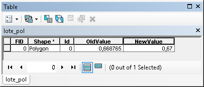
Although I still don't understand why you need to have only two decimals for doing a flood analysis, I think the easiest way would have been to do this at the polygon featureclass. Just create a new field and fill that with the field calculator with the number of decimals:

And use the resulting field in the Polygon to Raster conversion:
- Mark as New
- Bookmark
- Subscribe
- Mute
- Subscribe to RSS Feed
- Permalink
I just researched and got that you can find the flooded areas by using the values in the raster data but if there is any other way to get the flooded areas I am eagerly listening, because I have data in polygon files and raster data and I am trying to calculate the flooded areas in the raster. So if you have any other that would be great.
- Mark as New
- Bookmark
- Subscribe
- Mute
- Subscribe to RSS Feed
- Permalink
What value represents flooded? if you have polygons, if there isn't a geometry field called Shape_Area, then you can add a field yourself to the table and use the calculate geometry on that field. Of course, you can only hope that your polygon file is in projected coordinates, and not in geographic coordinates, otherwise you should project your polygon file to an appropriate projection prior to doing any calculations involving on geometry.
Addendum
Just had a look at your cell size.
Your polygon layer was in decimal degree coordinates. So you will have to calculate area using geodesic area, or project to a new file prior to doing any calculations.
- « Previous
-
- 1
- 2
- Next »
- « Previous
-
- 1
- 2
- Next »