- Home
- :
- All Communities
- :
- Products
- :
- Data Management
- :
- Data Management Questions
- :
- XY coordinates do not align with Shapefile
- Subscribe to RSS Feed
- Mark Topic as New
- Mark Topic as Read
- Float this Topic for Current User
- Bookmark
- Subscribe
- Mute
- Printer Friendly Page
- Mark as New
- Bookmark
- Subscribe
- Mute
- Subscribe to RSS Feed
- Permalink
I´ve been trying to fit XY coordinates with a shapefile.
So far, I've tried everything posted on previous discussions and forums, but had no success.
The GCS from my excel file is unknown (the sheet that I've been working with is "Delitos_Cabina" and it refers to crime incidents in Zapopan, a city in Jalisco, Mexico).
The GCS from my shapefile is ITRF_1992.
Could someone help me out with this?
Even if I define the GCS from the shapefile, it does not align.
Thanks in advance.
Guillermo
Solved! Go to Solution.
Accepted Solutions
- Mark as New
- Bookmark
- Subscribe
- Mute
- Subscribe to RSS Feed
- Permalink
This is what I did but please note that I am not guaranteeing this is the right answer, this is just based on my guess of the point data.
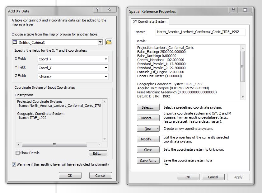
- Click File > Add Data > Add XY Data. and when the window pops up it will look like the image on the left, Then go to Edit button at the bottom, then a new window will pop up, like the one on the right, then hit Select. A new window will show up and then Navigate to Projected Coordinate Systems>UTM>Nad 1983>and select NAD 1983 UTM Zone 13N.prj. Hit OK all the way through and your points will look like mine.
- Mark as New
- Bookmark
- Subscribe
- Mute
- Subscribe to RSS Feed
- Permalink
Guillermo- the best way to post shapefiles is to zip all the components (shp, prj, shx, dbf) in one zip file.
That said, here are a couple of things to consider: GCS stands for Geographic Coordinate System. This is not truly a projection but rather what I would call a grid of convenience and the units are in Degrees of Latitude and Longitude.
I took a look in google for ITRF_92 and found the following older forum post on it: GCS_ITRF_92 - How Do i Project This?
Hope this helps-
- Mark as New
- Bookmark
- Subscribe
- Mute
- Subscribe to RSS Feed
- Permalink
Thank you very much for your answer.
Indeed, I am working with shapefiles from INEGI (Mexico's National Statistics and Geography Institute).
But my problem is not with the ITRF_92 itself, but with how do I manage to coincide both layers.
Even if I define the GCS from the excel file according to INEGI's layer, they don't match.
Here is what I've been doing:
First I import the shapefile and then the excel table.
Then, I Add XY Data and define the Coordinate System of Input Coordinates according to the shapefile description.
Nevertheless, they don't match.
I've also tried to switch XY coordinates, but the result is still the same.
Thanks
G
- Mark as New
- Bookmark
- Subscribe
- Mute
- Subscribe to RSS Feed
- Permalink
Just a though, I have looked at the excel spreadsheet and just based on the coordinates (and I know this is not the best way to determine what coordinate system you are working with) it seems like this is in UTM. After checking out online, this area of Mexico is in Zone 13. So when I defined them as UTM NAD83 zone 13, this is what I get. Tough to know for sure but it's an idea.
- Mark as New
- Bookmark
- Subscribe
- Mute
- Subscribe to RSS Feed
- Permalink
I know this is too much to ask, but could you explain to me step by step what did you do?
I defined both layers as you suggested, but the result wasn't the same.
In my case they still don't match. It must be something that I'm doing wrong (or not doing properly).
Thank you soooo much.
- Mark as New
- Bookmark
- Subscribe
- Mute
- Subscribe to RSS Feed
- Permalink
This is what I did but please note that I am not guaranteeing this is the right answer, this is just based on my guess of the point data.
- Click File > Add Data > Add XY Data. and when the window pops up it will look like the image on the left, Then go to Edit button at the bottom, then a new window will pop up, like the one on the right, then hit Select. A new window will show up and then Navigate to Projected Coordinate Systems>UTM>Nad 1983>and select NAD 1983 UTM Zone 13N.prj. Hit OK all the way through and your points will look like mine.
- Mark as New
- Bookmark
- Subscribe
- Mute
- Subscribe to RSS Feed
- Permalink
Thank you soooooooo much for all your help.
I've finally been able to fit both layers. I'm almost sure you're guess is right because when I added the other layers, all the points coincided.
One more thing, how did you identify in which part of Mexico this is located? (I mean how were you able to determine that this was in Zone 13?)
All the best
G
- Mark as New
- Bookmark
- Subscribe
- Mute
- Subscribe to RSS Feed
- Permalink
If you google utm zones or utm zones mexico, you find what you need
- Mark as New
- Bookmark
- Subscribe
- Mute
- Subscribe to RSS Feed
- Permalink
Glad that worked for you. I did a quick search online for the UTM zones in Mexico and came up with this document
http://www.uabcs.mx/geologia/geo_bajamx/sig/zonas_utm.pdf
and also double checked with this file that contains all the UTM zones in the world
https://community.esri.com/inbox?objectType=2&objectID=401487
- Mark as New
- Bookmark
- Subscribe
- Mute
- Subscribe to RSS Feed
- Permalink
Also- you may want to take a look at:
http://downloads2.esri.com/support/documentation/ao_/710Understanding_Map_Projections.pdf
This explains projections better than anything else out there.