- Home
- :
- All Communities
- :
- Products
- :
- Data Management
- :
- Data Management Questions
- :
- Re: Trouble Adding X,Y Data to Existing Map
- Subscribe to RSS Feed
- Mark Topic as New
- Mark Topic as Read
- Float this Topic for Current User
- Bookmark
- Subscribe
- Mute
- Printer Friendly Page
Trouble Adding X,Y Data to Existing Map
- Mark as New
- Bookmark
- Subscribe
- Mute
- Subscribe to RSS Feed
- Permalink
I'm somewhat new to ArcGIS and am having trouble adding data in X,Y coordinate form to my new map. I've looked over the topics here in depth but can't seem to figure out what's going wrong -- so thanks for any help you can give!
What's happening is that the data I'm adding, which are actually degrees, are projecting as if they were meters. So they are all in a few-square-meter cluster near 0, 0 degrees (off the coast of Africa). I thought this would happen if the coordinate and projections are different, but they appear to be the same.
Here are the steps I've taken:
1. Create new .MXD file. (I'm using version 10.5.1)
2. Add new baselayer, Open Street Map.
3. "Add XY Data" using an Excel (.XLSX) file. This Excel file contains one row for each location (they are child care providers), with columns for descriptive data, and a column each for the X coordinate and the Y coordinate. The X coordinates are around -140 and the Y's are around 40. The format in Excel for the fields was numeric with 8 decimal points. This yields an event layer. The data "look right" without reference to the map (i.e., they are dispersed correctly, showing me they are being interpreted as numeric data) - but are in the wrong place (at 0, 0 degrees)
4. I also exported the Event Layer into a shapefile, using the data frame's coordinate system. I can view the underlying attribute table fine, but the data are still in the weird location.
The complete Source infromation for the two items is below. Thanks again!
Data Frame:
WGS_1984_Web_Mercator_Auxiliary_Sphere
WKID: 3857 Authority: EPSG
Projection: Mercator_Auxiliary_Sphere
False_Easting: 0.0
False_Northing: 0.0
Central_Meridian: 0.0
Standard_Parallel_1: 0.0
Auxiliary_Sphere_Type: 0.0
Linear Unit: Meter (1.0)
Event Layer:
Data Type: XY Event Source
Location: C:\Users\Andrew...
Table: CLCCF$
X Field: POINT_X
Y Field: POINT_Y
Has Object-ID Field: No
Projected Coordinate System: WGS_1984_Web_Mercator_Auxiliary_Sphere
Projection: Mercator_Auxiliary_Sphere
False_Easting: 0.00000000
False_Northing: 0.00000000
Central_Meridian: 0.00000000
Standard_Parallel_1: 0.00000000
Auxiliary_Sphere_Type: 0.00000000
Linear Unit: Meter
Geographic Coordinate System: GCS_WGS_1984
Datum: D_WGS_1984
Prime Meridian: Greenwich
Angular Unit: Degree
- Mark as New
- Bookmark
- Subscribe
- Mute
- Subscribe to RSS Feed
- Permalink
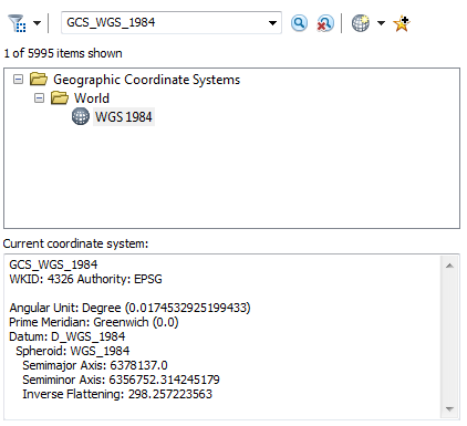
While using "Add XY Data", you should try to define the spatial reference as GCS_WGS_1984 (WKID:4326)
Think Location
- Mark as New
- Bookmark
- Subscribe
- Mute
- Subscribe to RSS Feed
- Permalink
That worked perfectly -- thanks!