- Home
- :
- All Communities
- :
- Products
- :
- Data Management
- :
- Data Management Questions
- :
- Re: Reproject Raster
- Subscribe to RSS Feed
- Mark Topic as New
- Mark Topic as Read
- Float this Topic for Current User
- Bookmark
- Subscribe
- Mute
- Printer Friendly Page
Reproject Raster
- Mark as New
- Bookmark
- Subscribe
- Mute
- Subscribe to RSS Feed
- Permalink
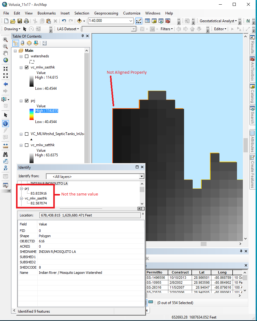
I'm working on a project and I need to reproject some rasters from NAD83 UTM to NAD83 SP. Easy enough. When I take a look at my original raster and my re-projected raster, I notice that they are not quite the same, however. As you can see in the screenshot. My original raster is on top (vc_mlw_sasthk in the table of conents) in black and white, my projected raster is on bottom (prj in table of contents) in a brighter color ramp and you can see it is not quite aligned with the original raster. You can also see that in some areas, the cell values have changed slightly (enough to make me worried).
My question: Anyone with experience in reprojecting rasters, have you ever run into this problem, and how were you able to resolve it?
I appreciate any ideas anyone has for troubleshooting/resolving this issue.
Thank you
- Mark as New
- Bookmark
- Subscribe
- Mute
- Subscribe to RSS Feed
- Permalink
Reprojection tends to introduce a bit of data massaging as the pixels which do not have any data will have to be given some value somehow during the resampling/rotation/ reprojection. If you need to maintain the actual values of the pixels you would need to convert the raster to points, reproject the points, then convert it back to raster of the exact same pixel size.
- Mark as New
- Bookmark
- Subscribe
- Mute
- Subscribe to RSS Feed
- Permalink
Rotation is a common cause of change when projecting a raster but in your case there is no datum transformation so I don't think there would be any rotation (but I could be wrong). A few questions for you to consider:
1. Which resampling technique did you select?
2. Did you specify the output cell size?
3. Did you specify a registration point in the tool or a snap raster in the Environment Settings?
You can find more details about each question in the Project Raster help document: Project Raster—Help | ArcGIS for Desktop
- Mark as New
- Bookmark
- Subscribe
- Mute
- Subscribe to RSS Feed
- Permalink
I used bilinear interpolation since my raster has continuous data (head, hydro-cond, porosity, etc), specified the cell size (made sure they were in the correct units as well), and I did snap to raster. I read somewhere else that projecting data into a different projection will always cause some mis-alignment due to the nature of projections. That pretty much answers my concern. Mike's answer above also helps explain why some of the values in the projected pixels were a bit different from the values in the original pixels. Thank you both for your replies.