- Home
- :
- All Communities
- :
- Products
- :
- Data Management
- :
- Data Management Questions
- :
- Re: Raster export not the right resolution
- Subscribe to RSS Feed
- Mark Topic as New
- Mark Topic as Read
- Float this Topic for Current User
- Bookmark
- Subscribe
- Mute
- Printer Friendly Page
Raster export not the right resolution
- Mark as New
- Bookmark
- Subscribe
- Mute
- Subscribe to RSS Feed
- Permalink
Hello,
I use arcmap desktop 10.2.2. In the workflow i use atm i make a geotiff use the export map option in arcmap. I need 4000dpi and i use geotiff tags and compression (LZW).
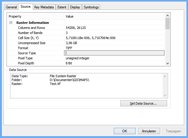
The resolutions of my geotiff is. See png
I use the geotiff as raster for a 3D simulation. The software i use for this needs a specific resolution. They need to by in the power of 2. So the rows and columns need to by 4096, 8192, 16384, 32768, 65536, 131072 etc.
As far as i know i cannot set this in arcmap. So i use qgis for this see png.
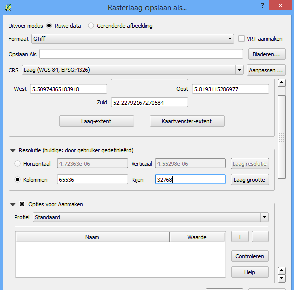
Only problem i have there that qgis is not that good with compression. My 120k kb geotiff is a 4194k geotiff after its the right size. This size is not good for the performance.
Is there a tool in arcmap where i can set the resolution? Or can anybody think off a workaround
thank you and greetings Peter
- Mark as New
- Bookmark
- Subscribe
- Mute
- Subscribe to RSS Feed
- Permalink
I presume that you tried exporting the 4194k QGIS produced geotiff inside of arcmap to a new file?
- Mark as New
- Bookmark
- Subscribe
- Mute
- Subscribe to RSS Feed
- Permalink
Yes i did try that but the problem there is that arcmap is making a bigtif from my tiff even if its under 4gb. the software i need the tiff for will not work with a bigtiff.
Do you know how i can make a tif and not a bigtif?
- Mark as New
- Bookmark
- Subscribe
- Mute
- Subscribe to RSS Feed
- Permalink
i have it allready i was looking at the file size and not the uncompressed size. uncompressed size was 6GB so its is a Bigtiff.
- Mark as New
- Bookmark
- Subscribe
- Mute
- Subscribe to RSS Feed
- Permalink
After much reading I think I have a solution were I do not need to use QGIS any more (going to try it on Monday at work) but there are also same questions.
The solution. After making a geotiff (4000dpi with 24bit with LZW compression)and importing it in the TOC you can right click the raster and go to data and export data and you are in the export raster data window.
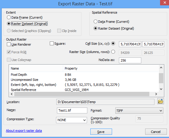
There I can do precisely what I want set the cell size but better even set the raster size (columns and rows). My geotiff need a dimension with a power of 2. So in this case 54209 is going to by 65536 and 26125 is going to by 32768.
The pixel depth is 8 bit but I did a export on 24bit can someone explain why that is (is it perhaps because I do not use that much color in my raster) ?
If this new geotiff works I have no more questions and my workflow became a lot less complicated .
Greetings peter.
- Mark as New
- Bookmark
- Subscribe
- Mute
- Subscribe to RSS Feed
- Permalink
peter,
To reduce the size of 'exported' TIFF (avoiding big TIFF), the simple way is to set the smaller cell size (saying, 0.5 m from 0.15 m) before beginning.
However, from your projection/ datum, it looks that the image uses WGS 84/ geodetic. Maybe, it is easy way to convert it into projected image, saying, UTM / WGS84...