- Home
- :
- All Communities
- :
- Products
- :
- Data Management
- :
- Data Management Questions
- :
- Re: Python Script to Project Shapefiles in a folde...
- Subscribe to RSS Feed
- Mark Topic as New
- Mark Topic as Read
- Float this Topic for Current User
- Bookmark
- Subscribe
- Mute
- Printer Friendly Page
Python Script to Project Shapefiles in a folder
- Mark as New
- Bookmark
- Subscribe
- Mute
- Subscribe to RSS Feed
- Permalink
I am very, very new to Python and I am trying to write a script that will allow me to Project shapefiles into a coordinate system that is assigned to one particular shapefile in a folder. So I have 4 files and one has that which I want to re-Project the others into. What I am struggling with is the output CS parameter required by the Project_management tool when called in the script. I get an error message saying that the output Coordinate System value and the outputFC parameter is not valid. I'm wondering where I'm going wrong.
Any help at all would be so greatly appreciated.
Sincerely,
Natasha
Solved! Go to Solution.
Accepted Solutions
- Mark as New
- Bookmark
- Subscribe
- Mute
- Subscribe to RSS Feed
- Permalink
The line
outFC = arcpy.os.path.join(outputFCpath, fc)
Joins the output path/folder and the input feature class name, so the output will not overwrite the input. This will create a new <fc>.shp in the output folder I set up as a variable at the top of the script.
....Once you feel you have your answer, make sure to mark one of the comments as "answered" and any others you find as helpful. This will help others find the solution, and will close this thread. thanks.
- Mark as New
- Bookmark
- Subscribe
- Mute
- Subscribe to RSS Feed
- Permalink
ok...even if it succeeds in your if else block it isn't going to project the file and you aren't giving it a coordinate system, just a name, also, you should add an arcpy overwriteoutputs line so you can experiment and overwrite stuff otherwise you will get a whole load of other errors.
- Mark as New
- Bookmark
- Subscribe
- Mute
- Subscribe to RSS Feed
- Permalink
Dan I found what you were talking about in the Project 2 sample script:
Project—Help | ArcGIS for Desktop
Thankyou
- Mark as New
- Bookmark
- Subscribe
- Mute
- Subscribe to RSS Feed
- Permalink
it was only a matter of time  keep at it
- Mark as New
- Bookmark
- Subscribe
- Mute
- Subscribe to RSS Feed
- Permalink
Natasha,
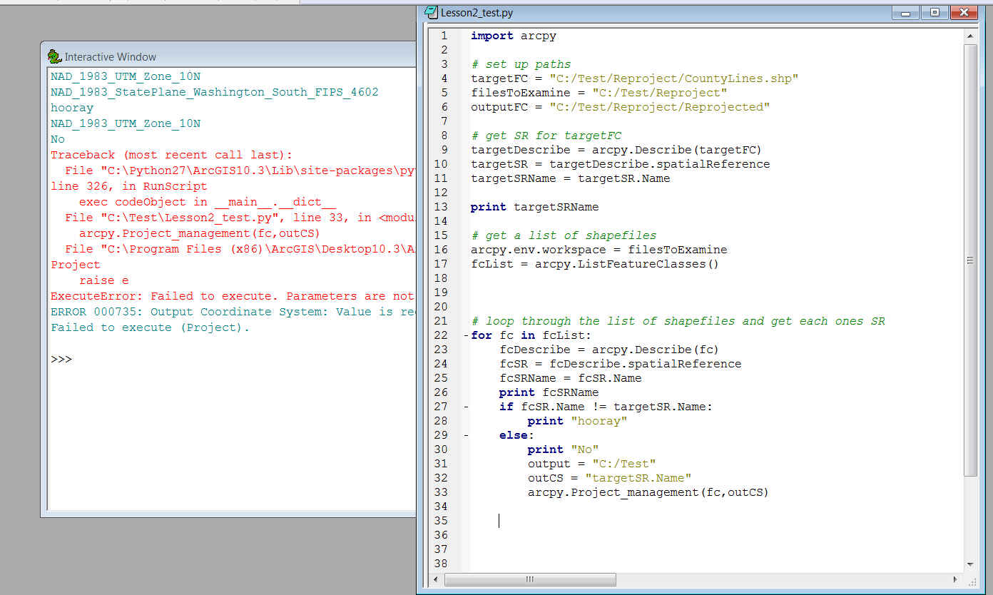
It looks like you are printing "hooray" if the don't match (!=) and trying to project them if they do. Try changing the != to == for the first part.
Then, as Dan mentioned, you have issues with you output, in fact the path set in the variable output isn't used. But, that is all part of the learning process. My guess is that is the reason you are creating the script, and not just running it once manually, then double clicking the command in the results tab and changing the input and output shape file?
- Mark as New
- Bookmark
- Subscribe
- Mute
- Subscribe to RSS Feed
- Permalink
Hmm thankyou Rebecca. I am trying hard to get this.
So I'll try changing the syntax but I'm still not sure where the output
CS is supposed to be iterated.
The print statements were just supposed to iterate which shapefiles were
supposed to be projected, or not.
I'm still unclear as to how this section is useful but I suppose it is
because I at least have a set of files that I know should be re projected.
So where should I put the == statement
What I want to accomplish is putting together a script that would
reproject shapefiles in a folder in different projections to one which I
have set.
I appreciate any continued help!
Thankyou Rebecca
On Sun, Oct 25, 2015 at 8:10 PM, Rebecca Strauch, GISP <[email protected]>
- Mark as New
- Bookmark
- Subscribe
- Mute
- Subscribe to RSS Feed
- Permalink
Natasha,
A tip for the future, when posting a question, it will help others help you if you follow the tips here Posting Code blocks in the new GeoNet But since it was a short script, I went ahead and started playing with the code myself. Dan had some good comments (and some help sources that you should look thru), but I've re-written the code...keeping the main flow of your script....but have the actual project comment commented out. I haven't quite got the correct syntax for that yet, but this may help you see some of the other issues you have.
UPDATED: this should work. Update your paths, and the targetFC of course. You had several this that needed fixing. Read thru this and hopefully you will see what it all means, but ask questions if it doesn't make sense. Keep in mind that shapefiles have a .prj file to assign the projection, and if this is missing the command will have problem projecting. A missing projection will cause issues for any feature class, but shapefiles in particular are a bit more simplistic, so to speak.
import arcpy

#setup pathc
targetFC = r"c:\__projIn\gmu.shp"
filesToExamine = r"c:\__projIn"
outputFCpath =   r"c:\__ProjOut"

# get SR for targetFC
targetDescribe = arcpy.Describe(targetFC)
targetSR = targetDescribe.spatialReference
targetSRName = targetSR.Name

print targetSRName

# get a list of shapefiles
arcpy.env.workspace = filesToExamine
fcList = arcpy.ListFeatureClasses()

# loop through the list
for fc in fcList:
  fcDescribe = arcpy.Describe(fc)
  fcSR = fcDescribe.spatialReference
  fcSRName = fcSR.Name
  print fcSRName
  if fcSR.Name == targetSR.Name:
    print "hooray"
  else:
    print "No"
    outFC = arcpy.os.path.join(outputFCpath, fc)
    arcpy.Project_management(fc, outFC, targetSR)
- Mark as New
- Bookmark
- Subscribe
- Mute
- Subscribe to RSS Feed
- Permalink
Rebecca I am looking through this reply and I very much appreciate you
response and I am so new to Python that I am thoroughly confused.
I also appreciate Dans replies and I am learning from all of it!
outFC = arcpy.os.path.join(outputFCpath, fc)
the above line confuses me as I don't know where to put os and Ive not
understood it nor have we used it in our syntax however I will try to
incorporate it in my code and accommodate what you so generously have
helped try to write.
Also, I will go through the documentation that you and Dan have
advised me to do both in posting and in realizing the skillset.
Thankyou very much, very much.
Cheers,
~Natasha
I'm trying right now and again, I appreciate your assistance.
On Sun, Oct 25, 2015 at 8:53 PM, Rebecca Strauch, GISP <[email protected]>
- Mark as New
- Bookmark
- Subscribe
- Mute
- Subscribe to RSS Feed
- Permalink
The line
outFC = arcpy.os.path.join(outputFCpath, fc)
Joins the output path/folder and the input feature class name, so the output will not overwrite the input. This will create a new <fc>.shp in the output folder I set up as a variable at the top of the script.
....Once you feel you have your answer, make sure to mark one of the comments as "answered" and any others you find as helpful. This will help others find the solution, and will close this thread. thanks.
- Mark as New
- Bookmark
- Subscribe
- Mute
- Subscribe to RSS Feed
- Permalink
Rebecca this is really helpful and I so appreciate it.
Thanks so much for this information.
I will follow your direction as per information on the GeoNet site.
Again. Many thanks.
On Sun, Oct 25, 2015 at 9:44 PM, Rebecca Strauch, GISP <[email protected]>