- Home
- :
- All Communities
- :
- Products
- :
- Data Management
- :
- Data Management Questions
- :
- Re: Polygon from slope change (Raster/LIDAR)
- Subscribe to RSS Feed
- Mark Topic as New
- Mark Topic as Read
- Float this Topic for Current User
- Bookmark
- Subscribe
- Mute
- Printer Friendly Page
Polygon from slope change (Raster/LIDAR)
- Mark as New
- Bookmark
- Subscribe
- Mute
- Subscribe to RSS Feed
- Permalink
HI there.
I’m working on a project, where I would like to create polygons, where there is a slope change above 60 degrees, and it would be great if the lines where as smooth as possible. So this is pretty new to me, but I have tried to get this to work, with my own ideas, but I haven’t succeed yet.
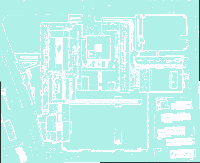
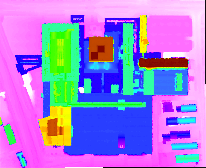
I got my DSM, and I have used a GP tool slope, to get a raster which actually visually is close to what I need. I’ve reclassed the Raster into two classes, and I’ve also tried a int.
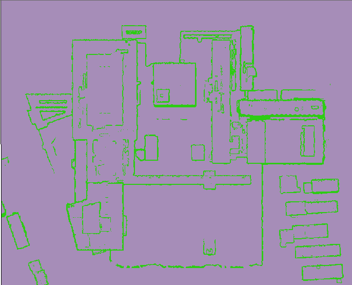
Then I’ve tried converting the raster to TIN, removed Hillshades, and again reclassed. This also looks like a start.
My DSM:
Now I’m thinking that a better way, if possible could be something like (Thinking out loud):
Something like the TIN view, combined with the DSM, but make the raster grow into each other, and nicely split by the significant overlap??
I got a detailed LIDAR dataset classified with the spacing of 0.4 meters. If there is an easier workflow with the use of LIDAR, I am all ear.
Thanks
- Mark as New
- Bookmark
- Subscribe
- Mute
- Subscribe to RSS Feed
- Permalink
It's not clear to me what you're trying to achieve or what's wrong with what you've produced.
- Mark as New
- Bookmark
- Subscribe
- Mute
- Subscribe to RSS Feed
- Permalink
Sorry if I didn’t explain myself probably, and thanks letting me know.
This is maybe also a hard building too start out with. My issue is that I got building polygons, with many different heights and roof forms. So I need to split the building polygon up, whenever the slope differ more than 60 degrees. On the above pictures, I’m able to use the raster to produce very jagged polygons. So I’m looking for a way to get the polygons as close to each other, and minimize the jagged lines. I was thinking about something like creating a line in the significant slope raster. Because of my raster resolution 0.4 m spacing, my slope raster (green lines in the first picture) is around 0.8 m.
Imagine you got a church and you want to split, or create a new polygon, where you got the church tower. If you could do that, then you would be able to extrude the 2 new polygons in different height.
I guess if I could extend (buffer) each raster between the slope, to minimize the slope spacing, I could get far.
Makes sence?
- Mark as New
- Bookmark
- Subscribe
- Mute
- Subscribe to RSS Feed
- Permalink
I came across this article which uses LiDAR Data and Orthophotos to reconstruct 3D building rooftops and has some interesting results:
To do what you were saying, you might want to use height, slope and aspect information to derive the distinct areas within a building polygon. Since this is a raster analysis, you will have to convert the raster areas to polygons (smooth the result) and combine them with the building polygon. This will required eliminating small areas, include them in the largest neighboring polygon and fill areas that resulted unclassified.
If there are many polygons you have to process, you might want to explore some commercial products that do this type of analysis...