- Home
- :
- All Communities
- :
- Products
- :
- Data Management
- :
- Data Management Questions
- :
- Re: 'extract multi values to points' or 'sample' n...
- Subscribe to RSS Feed
- Mark Topic as New
- Mark Topic as Read
- Float this Topic for Current User
- Bookmark
- Subscribe
- Mute
- Printer Friendly Page
'extract multi values to points' or 'sample' not work if the raster is in a geodatabase?
- Mark as New
- Bookmark
- Subscribe
- Mute
- Subscribe to RSS Feed
- Permalink
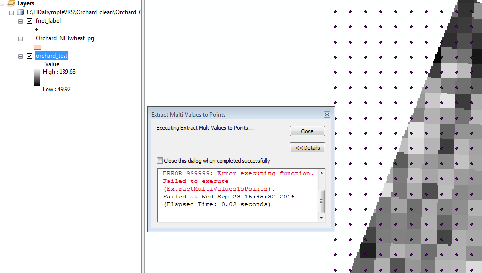
I used 'extract multi values to points' or 'sample' to extract values from several rasters but I kept getting error 999999.
They work fine if I save the rasters under a folder rather than geodatabase.
'Extract values to points' can work even the raster is in geodatabase.
Just to confirm is that a tool bug or something?
Solved! Go to Solution.
- Mark as New
- Bookmark
- Subscribe
- Mute
- Subscribe to RSS Feed
- Permalink
Cant help but notice you used the Define Projection tool... Defining it doesn't make it so, if it is in a different coordinate system to begin with. You only use Define Projection, when a file has no coordinate system or it is missing or you need to fix it. If it has a coordinate system, but it is not the one your want, then you use the project tool.
Thinks can go badly if this is done incorrectly.... for example
/blogs/dan_patterson/2016/09/07/define-projection-vs-project-a-visual-guide
- Mark as New
- Bookmark
- Subscribe
- Mute
- Subscribe to RSS Feed
- Permalink
What confuses me is that the points and the raster are in the same coordinate system 'NZGD2000'. But 'extract multi values' tool runs ok when the raster is in a folder.
- Mark as New
- Bookmark
- Subscribe
- Mute
- Subscribe to RSS Feed
- Permalink
when you say raster... what format? esri grid? tif?. esri grids have naming requirements and limitations that some other formats don't have. As long as you are aware of those, then things are fine. If stuff works in a folder, put it there, you can always copy/export elsewhere once you have what you need. Isn't the important requirement that you get the result? Trying to micromanage all aspects of a gis workflow will drive you crazy. Get the job done, then worry about cleaning house and tidying up.
- Mark as New
- Bookmark
- Subscribe
- Mute
- Subscribe to RSS Feed
- Permalink
I use 'polygon to raster' conversion to convert my files into raster. So it is in GRID.
- Mark as New
- Bookmark
- Subscribe
- Mute
- Subscribe to RSS Feed
- Permalink
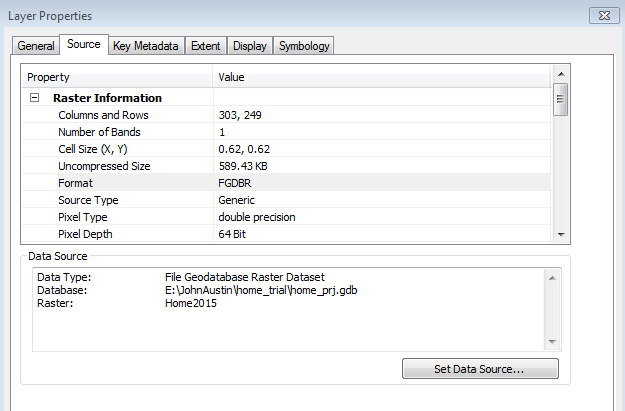
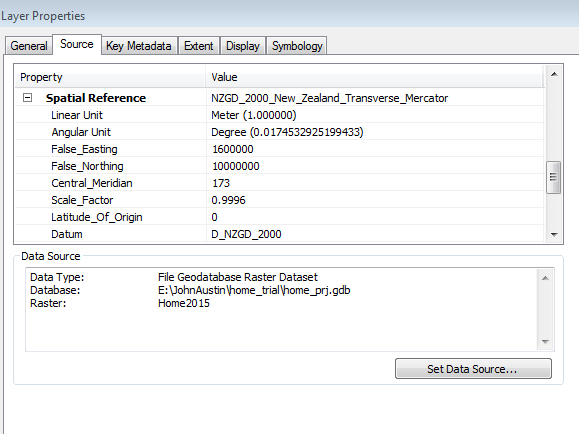
that is good... so you have it saved to a folder with no spaces, doesn't begin with a number... the grid name is 8 characters or less, doesn't contain any spaces or begin with a number... good as well. Interesting cell size... 4.8*10-6. Obviously an unprojected raster since if it were in meters, then you have a cell width of about 5 micrometers. So I am guessing that it is about 5*10^-6 degrees. Is that about right? What geographic coordinate system is it defined as? and what are the results of a projection since you indicated that you were using projected data.
- Mark as New
- Bookmark
- Subscribe
- Mute
- Subscribe to RSS Feed
- Permalink
Please find my last edited reply. The previous screen shot was the one that's working.
- Mark as New
- Bookmark
- Subscribe
- Mute
- Subscribe to RSS Feed
- Permalink
the previous screen shot with the cell size of 0.62 decimal degrees, (obviously unprojected data in a geographic coordinate system) seems reasonable and it comes as no surprise that it works. The second screen shot with the cell size of about 5 micrometers .... since it is apparently in a projected coordinate system... is wrong. Yes, glad you can confirm that. So I suspect that the Define Projection was used and the file was not actually physically projected and given the cell size and extent... a geodatabase won't let it in to be with the other files, since it by no means fits within the realm possible acceptable values. This may account for the reason that it can be saved to a folder, but isn't allowed into the geodatabase to reside with the other layers.
- « Previous
-
- 1
- 2
- Next »
- « Previous
-
- 1
- 2
- Next »