- Home
- :
- All Communities
- :
- Products
- :
- Data Management
- :
- Data Management Questions
- :
- Re: Duplicated decimal coordinate values?
- Subscribe to RSS Feed
- Mark Topic as New
- Mark Topic as Read
- Float this Topic for Current User
- Bookmark
- Subscribe
- Mute
- Printer Friendly Page
Duplicated decimal coordinate values?
- Mark as New
- Bookmark
- Subscribe
- Mute
- Subscribe to RSS Feed
- Permalink
Hello. I hope someone can help me with what appears to be an odd problem.
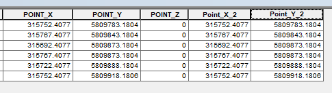
In ArcMap Desktop v10.5.1 I have calculated EN coordinates for a set of sample points for field work. However, I noticed that the coordinate values all have the same decimal values regardless of where they are located. The points are not located in a line so how can they have the same decimal values? For example, two completely separate point locations some 60 metres apart have the following values: P1 is E 315722.4077 / N 5809888.1804, P2 is E 315767.4077 / N 5809843.1804.
Please see attached image.
ALL the points have these same repeated decimal values. The field type is Double and precision is set to 6 decimal places. The data frame is correct with all project data in GDA_1994_MGA_Zone_55.
The same points calculated using DMS have unique values and are NOT duplicated at the seconds (") level. Hmmm
Thanks for any help or tips in advance!
Grant
- Mark as New
- Bookmark
- Subscribe
- Mute
- Subscribe to RSS Feed
- Permalink
How did you calculate those values?
From the Shape field?
using the field calculator?
In ArcMap or ArcGIS Pro?
- Mark as New
- Bookmark
- Subscribe
- Mute
- Subscribe to RSS Feed
- Permalink
Hi Dan,
Thanks for your questions.
How did you calculate those values?
By right-clicking on the filed name and selecting Calculate Geometry...
Selecting X/Y Coordinate of Point for each separate field and confirming the units in Meters (m) and coordinates are correct.
From the Shape field?
No.
using the field calculator?
Yes
In ArcMap or ArcGIS Pro?
ArcMap (10.5.1)
Thank you.
- Mark as New
- Bookmark
- Subscribe
- Mute
- Subscribe to RSS Feed
- Permalink
Hi Dan,
Sorry, I did NOT use the Field Calculator.
Apologies for any confusion.
Grant
- Mark as New
- Bookmark
- Subscribe
- Mute
- Subscribe to RSS Feed
- Permalink
Well if your image is correct the points X and Y values should be distinct as you expect.
On a lark, try the Add XY Coordinates tool from ArcToolbox first. From there, you could try a manual field calculation for the X and Y coordinates separately
Python parser.... in the field calculator
!Shape.centroid.X! and !Shape.centroid.Y! if memory serves
- Mark as New
- Bookmark
- Subscribe
- Mute
- Subscribe to RSS Feed
- Permalink
Hi Dan,
Once again, thanks for the tips. I have done each method and the results are the same (below).
I'll look for another idea as presently I'm at a loss (and out of time). First time I've seen this actually. Hmmm
I'll let you know when I find a solution.
Many thanks,
Grant
- Mark as New
- Bookmark
- Subscribe
- Mute
- Subscribe to RSS Feed
- Permalink
I am beginning to suspect that the repeating decimals are due to floating point issues.
Was the featureclass assigned a projected coordinate system when it was created?
If not, there is a long history of geometry errors... albeit small... being introduced. These still exist if geometry is created either in a featureclass or a shapefile, and a coordinate system is not assigned (Define Projection) or assigned during a projection to a projected coordinate system from a geographic coordinate system.
You would have to re-adjust your workflow to include the definition prior to producing a featureclass and calculating geometry values.
- Mark as New
- Bookmark
- Subscribe
- Mute
- Subscribe to RSS Feed
- Permalink
Hi Dan,
Ok. good thinking. Yes, it's a newly created FC with an assigned CRS before creating geometry. It is part of an ongoing project completely controlled by us and no conversions between projected and geographic coords has occurred.
I will investigate the FC and see if I can duplicate it anew to see if that works.
Cheers,
Grant
- Mark as New
- Bookmark
- Subscribe
- Mute
- Subscribe to RSS Feed
- Permalink
I'm pretty sure that the values return by the Geometry calculation and the Add XY Coordinates—Help | ArcGIS Desktop tool that Dan suggested present the actual coordinates of the geometry. It will be more important to see how the points were created, like were all the points created at the same display scale of the map? Also are you using high precision for your data (in what format is it stored). Was there any snapping applied during the creation of the point geometries?
- Mark as New
- Bookmark
- Subscribe
- Mute
- Subscribe to RSS Feed
- Permalink
I can see no problem with duplicated decimal coordinate values.
because they are align and fixed size (grids) polygons .and your points are the center of this polygons
so the coordinates are logical.
