Turn on suggestions
Auto-suggest helps you quickly narrow down your search results by suggesting possible matches as you type.
Cancel
- Home
- :
- All Communities
- :
- Products
- :
- Data Management
- :
- Data Management Questions
- :
- Re: Deciphering the Language of Metes and Bounds
Options
- Subscribe to RSS Feed
- Mark Topic as New
- Mark Topic as Read
- Float this Topic for Current User
- Bookmark
- Subscribe
- Mute
- Printer Friendly Page
01-30-2012
12:23 PM
- Mark as New
- Bookmark
- Subscribe
- Mute
- Subscribe to RSS Feed
- Permalink
Hello everyone!
I am the GIS intern for the City of Lake Forest, CA, and I am having trouble deciphering the legal city boundary description, written in metes and bounds. The purpose is to check the accuracy of our current layer. I am using the traverse tool.
Here is the first part of the description:
Beginning at a point in the existing boundary line of the City of Mission Viejo as created by ???Incorporation??? of said city, said point being at the centerline intersection of El Toro Road as established by Orange County Surveyor???s Map 77-3 and shown by map of Tract No. 9667 filed in Book 475 Pages 33 thru 39 inclusive of Miscellaneous Maps in the office of the County Recorder of said Orange County, with that certain course described in said ???Incorporation??? as ???North 16°11???38??? East, 406.15 feet???, said point being on a non-tangent curve concave Northerly having a radius of 1600 feet, a radial to said point bears South 04°03???50??? East;
Thence, following along said existing boundary line per said ???Incorporation???, the following described courses: South 16°11???38??? West, 344.90 feet;
Thence South 46°49???42??? West, 715.39 feet;
Thence South 80°51???43??? West, 632.58 feet;
Etc???
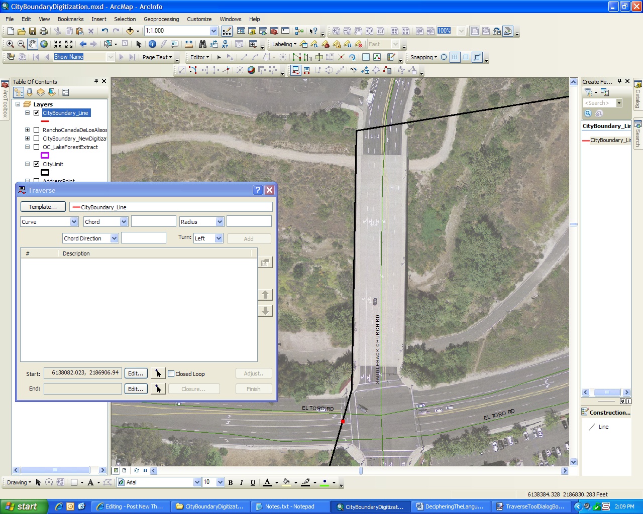
Ah! I think that I understand how to enter in the information regarding straight segments, but the non-tangent curve confuses me greatly. Can someone please help me figure out how to enter this information into the traverse tool dialog box? Here is a screen shot:
[ATTACH=CONFIG]11543[/ATTACH]
The left-hand side is the City of Lake Forest and the right-hand side is the City of Mission Viejo. The red dot is my starting point. Also, I am creating a line feature class instead of a polygon feature class because that is what I was instructed to do by ESRI technical support. We obviously did not resolve this issue and that is why I am posting in this forum.
I will appreciate any and all help that I can get. Thank you!
Brittany
I am the GIS intern for the City of Lake Forest, CA, and I am having trouble deciphering the legal city boundary description, written in metes and bounds. The purpose is to check the accuracy of our current layer. I am using the traverse tool.
Here is the first part of the description:
Beginning at a point in the existing boundary line of the City of Mission Viejo as created by ???Incorporation??? of said city, said point being at the centerline intersection of El Toro Road as established by Orange County Surveyor???s Map 77-3 and shown by map of Tract No. 9667 filed in Book 475 Pages 33 thru 39 inclusive of Miscellaneous Maps in the office of the County Recorder of said Orange County, with that certain course described in said ???Incorporation??? as ???North 16°11???38??? East, 406.15 feet???, said point being on a non-tangent curve concave Northerly having a radius of 1600 feet, a radial to said point bears South 04°03???50??? East;
Thence, following along said existing boundary line per said ???Incorporation???, the following described courses: South 16°11???38??? West, 344.90 feet;
Thence South 46°49???42??? West, 715.39 feet;
Thence South 80°51???43??? West, 632.58 feet;
Etc???
Ah! I think that I understand how to enter in the information regarding straight segments, but the non-tangent curve confuses me greatly. Can someone please help me figure out how to enter this information into the traverse tool dialog box? Here is a screen shot:
[ATTACH=CONFIG]11543[/ATTACH]
The left-hand side is the City of Lake Forest and the right-hand side is the City of Mission Viejo. The red dot is my starting point. Also, I am creating a line feature class instead of a polygon feature class because that is what I was instructed to do by ESRI technical support. We obviously did not resolve this issue and that is why I am posting in this forum.
I will appreciate any and all help that I can get. Thank you!
Brittany
Solved! Go to Solution.
1 Solution
Accepted Solutions
02-03-2012
04:15 AM
- Mark as New
- Bookmark
- Subscribe
- Mute
- Subscribe to RSS Feed
- Permalink
I'm not all that familiar with the differences in tangent and non-tangent curves, but in my experience I've still used just the radius and length values to draw a tangent curve and it draws correctly, so maybe just try a "tangent curve" in the traverse tool and see what happens. I've never understood why they seem to leave out some of those other curve information when drawing up a survey or description.
8 Replies
01-31-2012
08:41 AM
- Mark as New
- Bookmark
- Subscribe
- Mute
- Subscribe to RSS Feed
- Permalink
Brittany,
I read over the legal description you provided and it seems to be missing some key information to construct a non-tangent curve.
You typically need four pieces of information to properly construct one:
1) Arc Length or Delta (angle)
2) Curve Direction (Left or Right)
3) Radial Direciton
4) Radius
There are some other pieces of information that can subsitute for some of each of these but in general these are the 4 pieces of information you will see in legal descriptions.
The legal description you provided only includes 3 of the 4.
Without knowing either the length of the curve (arc length) or the delta (angle) you cannot construct this non-tangent curve.
I would suggest researching deeds or any other document such as a survey, plat, short plat, or boundary adjustment, to find a proper description of this arc.
*Note: Radial line bearings are generally given from the radius point to the point on the arc. So when you input the radial bearing you would flip the direction in this case from S 04°03�??50�?� E to N 04°03�??50�?� W.
This is probably not exactly what you were looking for but I hope it helps.
Joel Calhoun
Sr. GIS Analyst
Snonohsh County, WA
Assessor's Office
01-31-2012
10:13 AM
- Mark as New
- Bookmark
- Subscribe
- Mute
- Subscribe to RSS Feed
- Permalink
Thank you for your response!
That would be really odd if our city's original incorporation file was missing information, like you said. I initially thought I had enough information to create the curve because the curve calculator help section says that "The Curve Calculator lets you determine the complete characteristics of a curve from two known parameters." I entered the chord distance (406.15 ft) and the radius (1600 ft) and found the angle, arc length, chord height, and tangent length. But, it did not tell me the chord, radial, or tangent direction like I need. Also, I believe that "concave Northerly" is trying to tell me either left or right. Ugh. I will try to find more documents.
I appreciate your help!
Anyone else know what I should do?
02-01-2012
11:26 AM
- Mark as New
- Bookmark
- Subscribe
- Mute
- Subscribe to RSS Feed
- Permalink
Okay. I have now switched to reading the bearings and distances off the much simpler paper map table, instead of the confusingly worded 8 page document. This is working out better, but, I am still missing information for the curves. The table gives me the following information:
Curve A...
Delta: 20 degrees 50' 32"
Radius: 1800 ft
Length: 654.78 ft
At least I have the delta now! Yay! But, I still don't have the chord, radial, or tangent direction like I need. I looked those types of directions up in the GIS dictionary and found nothing.
This is just an update. Help please. Thank you!
02-02-2012
05:33 AM
- Mark as New
- Bookmark
- Subscribe
- Mute
- Subscribe to RSS Feed
- Permalink
Here's a thought, since you have some info on the curve that you can use to draw a tangent curve (length and radius), you could try working backwards throught the described bearings and distances, but that only works if the last described line is a straight line. If so, I'd suggest starting at the original point of beginning (POB) and then use the back bearing of the last described line as the first line of your traverse. Does that make sense? To get the back bearings, just use the opposite direction, such as S 16-11-38 W turns into N 16-11-38 E. When you get to the last line, which would be the curve, just draw it as a tangent curve and use the length and radius that you know. If the line doesn't close back to the POB, you could then select the curved line and rotate it until it snaps to the POB.
I hope that makes sense and helps you,
Bill
I hope that makes sense and helps you,
Bill
02-02-2012
12:50 PM
- Mark as New
- Bookmark
- Subscribe
- Mute
- Subscribe to RSS Feed
- Permalink
I think that I follow you. The problem is that there are many curves throughout the boundary, so no matter which way I go (clockwise or counterclockwise), I am bound to run into a curve that does not have an end point to snap to. Either way, when I am prompted to create a curve in the traverse dialog box, a chord, radial, or tangent direction is needed, which I don't think I have. So frustrating. I hope that I figure this out soon. Thank you for your help! 🙂
02-03-2012
04:15 AM
- Mark as New
- Bookmark
- Subscribe
- Mute
- Subscribe to RSS Feed
- Permalink
I'm not all that familiar with the differences in tangent and non-tangent curves, but in my experience I've still used just the radius and length values to draw a tangent curve and it draws correctly, so maybe just try a "tangent curve" in the traverse tool and see what happens. I've never understood why they seem to leave out some of those other curve information when drawing up a survey or description.
02-03-2012
09:29 AM
- Mark as New
- Bookmark
- Subscribe
- Mute
- Subscribe to RSS Feed
- Permalink
Haha. I changed my 'curve' to 'tangent curve', and now everything seems to be working out, at least for now. I feel silly not changing this setting before, but I was stuck on the statement 'said point being on a non-tangent curve' which referred to the first curve heading counterclockwise. I am now heading clockwise and there is no mention of non-tangent curves. I think I'm going to see if the tangent curve settings work for non-tangent curve described above. I know that sounds like the completely wrong thing to do... but I don't know what else to do without the chord, radial, or tangent direction information. Ehh. Also, the curve table doesn't differentiate between any of the curves anyway, so I might be right. Thank you for all your help everybody!
02-03-2012
10:30 AM
- Mark as New
- Bookmark
- Subscribe
- Mute
- Subscribe to RSS Feed
- Permalink
I'm glad you got it to work Brittany! I can imagine your reaction when you had that eureka moment when it worked! I've been in the same situation as you, being stuck on that term "non-tangent" and struggling to work past that. But like I said earlier, it doesn't always work out right by just simply doing the length and radius of a tangent curve, but most of the time it seems to work. Good luck!