- Home
- :
- All Communities
- :
- Products
- :
- Data Management
- :
- Data Management Questions
- :
- Re: Creating points at a specific distance from ot...
- Subscribe to RSS Feed
- Mark Topic as New
- Mark Topic as Read
- Float this Topic for Current User
- Bookmark
- Subscribe
- Mute
- Printer Friendly Page
Creating points at a specific distance from other points along a line
- Mark as New
- Bookmark
- Subscribe
- Mute
- Subscribe to RSS Feed
- Permalink
I have a network file (polyline) and I have a separate point file. The point file FIELDS include coordinates of the starting point and "LENGTH" which is distance along the line from the starting point.
Now, I want to create or locate points along the line which are at "LENGTH" distances from the starting points in the point file.
First, I created a route from the transportation network file.
Then, I added the starting points as events along the route.
But, I am not able to figure out how to create a new set of route events which are at specific distance from the first set of route events along the route.
I am using ArcGIS 10.2.2 Desktop
Any help is greatly appreciated. Thank you.
Solved! Go to Solution.
Accepted Solutions
- Mark as New
- Bookmark
- Subscribe
- Mute
- Subscribe to RSS Feed
- Permalink
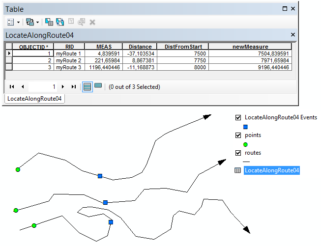
OK, so I created a few lines, added some points near the start of the line and created routes from the lines.
I created a field "DistFromStart" with some values of the distance from the start (or actually the point).
My steps were as follows:
- Locate Features Along Routes (this creates the event table shown below)
- I added a field "newMeasure" which is the measure of the input point from the start of the line and I added the DistFromStart to this value to create a measure from the start of the line
- Then I used the Make Route Event Layer to create the event points (blue squares) which is what you are looking for (as far as I understand)
- Mark as New
- Bookmark
- Subscribe
- Mute
- Subscribe to RSS Feed
- Permalink
Normally you would use the Make Route Event Layer tool to convert a table with "events" to for instance points. Do you have the route identifier in the point file attribute table?
Read more on dynamic segmentation here: ArcGIS Help (10.2, 10.2.1, and 10.2.2)
The other way to go would be the use of some python code. No need to have a network, just polylines will do:
- Loop through the points
- For each point define which line (route) belongs to it
- Use the arcpy.Polyline.positionAlongLine(value, {use_percentage}) to get the point
- Mark as New
- Bookmark
- Subscribe
- Mute
- Subscribe to RSS Feed
- Permalink
Thanks for your reply Xander. In fact, I used the Make Route Event Layer tool to create a table with events. I also have the RID in the event table. But, now I need to create a second set of events which are at a specific distance from the first set of events along the polyline. Is there no way to do this without the python script?
- Mark as New
- Bookmark
- Subscribe
- Mute
- Subscribe to RSS Feed
- Permalink
That's odd. I would expect this tool to create a layer from the events.
Could you attach a small sample of your data (some lines and corresponding points)?
- Mark as New
- Bookmark
- Subscribe
- Mute
- Subscribe to RSS Feed
- Permalink
OK, so I created a few lines, added some points near the start of the line and created routes from the lines.
I created a field "DistFromStart" with some values of the distance from the start (or actually the point).
My steps were as follows:
- Locate Features Along Routes (this creates the event table shown below)
- I added a field "newMeasure" which is the measure of the input point from the start of the line and I added the DistFromStart to this value to create a measure from the start of the line
- Then I used the Make Route Event Layer to create the event points (blue squares) which is what you are looking for (as far as I understand)
- Mark as New
- Bookmark
- Subscribe
- Mute
- Subscribe to RSS Feed
- Permalink
Thanks Bakker! I could replicate your steps in my case. Thank again for the splendid example and please excuse me for the delayed response.
- Mark as New
- Bookmark
- Subscribe
- Mute
- Subscribe to RSS Feed
- Permalink
You´re welcome! BTW my first name is Xander....