- Home
- :
- All Communities
- :
- Products
- :
- Data Management
- :
- Data Management Questions
- :
- Re: creating candidate layer
- Subscribe to RSS Feed
- Mark Topic as New
- Mark Topic as Read
- Float this Topic for Current User
- Bookmark
- Subscribe
- Mute
- Printer Friendly Page
creating candidate layer
- Mark as New
- Bookmark
- Subscribe
- Mute
- Subscribe to RSS Feed
- Permalink
Hi there,
I am still a beginner to gis and I am trying to do a network analysis for finding optimum litter bins in an area. I already have data for existing litter bins however I need to create data for candidate litter bins which could be an option to place a litter bin in that area. With placing litter bins in that area, there is no restriction, so what could be a best way to locate candidate layer using network analysis?
Many thanks
Nirodha
- Mark as New
- Bookmark
- Subscribe
- Mute
- Subscribe to RSS Feed
- Permalink
determine the 'service area' for the existing bins based on some perception of what would be the optimal spacing of the bins (say every 200 -250 meters). Once you discover the areas delineated by the existing bins you will get some idea whether your guess is appropriate or needs modification. If the areas for the existing bins seem appropriately spaced, then the empty intervening space will give you some idea as to where new bins can be placed.
Always explore the existing data first...they are there for a reason...could be inter bin spacing...could be proximity to stores/restaurants/fast food locations or a variety of other reasons. Once you understand that, then you can proceed to placement. Think about it...there is no reason to place bins at finite distance increments along a road, when placing them at rest stops makes sense.
Next post from you...show your pattern, the visuals will help readers get other ideas.
- Mark as New
- Bookmark
- Subscribe
- Mute
- Subscribe to RSS Feed
- Permalink
Thank you Dan,
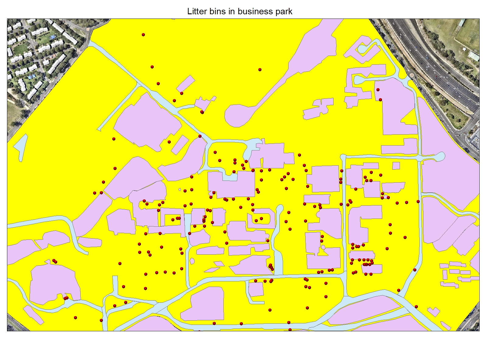
It really helps. I have attached the pattern of litter bins in the study area.
Many thanks
Nirodha
- Mark as New
- Bookmark
- Subscribe
- Mute
- Subscribe to RSS Feed
- Permalink
Nirodha...
First impressions:
- what are the reddish areas? building? (I hope not) buildings plus stuff?
- there are some linear patterns within the data, suggesting paths....where are those?
- there are clusters of points near the unknown red areas...some at specific groupings some appear linearly along the 'thing'...what is near the existing bins.
- there are large areas of yellow...first question...why no bins? forbidden zone? no paths? parking lot? forest? why is this important? you need to delineate areas where bins 'cannot' appear. That is just as important as where they 'can' locate.
- the bluish objects look like roads...or canals...or just poorly digitized things...for the most part there are no bins in them, but usually beside them (except for one lone point in the bottom right hand corner...either a misplaced bin...people messing with bin placement...strategically located drive-thru bin service?
So, the pattern is interesting, but there are more aspects that you have to identify in the landscape that can account for the existing pattern before you can go forward with addressing where they should be located. I can say for the most part, that there is very little to support the inter-bin spacing theory as controlling the existing pattern. There is more factors .... (doors, proximity to activities within the reddish things, etc etc)
Look more and report back...
- Mark as New
- Bookmark
- Subscribe
- Mute
- Subscribe to RSS Feed
- Permalink
Hi Dan,
I have tried to answer on points, hope this makes sense.
- what are the reddish areas? building? (I hope not) buildings plus stuff?
- Yes these are buildings and surrounding areas where areas have boundaries.
- there are some linear patterns within the data, suggesting paths....where are those?
- the red linear line is creek (digitized)
- there are clusters of points near the unknown red areas...some at specific groupings some appear linearly along the 'thing'...what is near the existing bins.
- cluster of red points (bins) are because these are seating areas, and therefore bins are placed aside near most of the seating areas
- there are large areas of yellow...first question...why no bins? forbidden zone? no paths? parking lot? forest? why is this important? you need to delineate areas where bins 'cannot' appear. That is just as important as where they 'can' locate.
- Parking lot, forest areas and grassland (accessible for people to walk through) but have lower pedestrian movements around those areas
- the bluish objects look like roads...or canals...or just poorly digitized things...for the most part there are no bins in them, but usually beside them (except for one lone point in the bottom right hand corner...either a misplaced bin...people messing with bin placement...strategically located drive-thru bin service?
- yes, blue objects are roads, yes your right that there are little bins beside these roads.
Is it possible to do a search for location for litter bins in every 5 minutes and create candidate layer out of this. And later do a location allocation with the data? (I also have created a population density data)
Many thanks
Nirodha
- Mark as New
- Bookmark
- Subscribe
- Mute
- Subscribe to RSS Feed
- Permalink
Yes on your last venture, it would be interesting to see that...now you just have to focus your ideas on ... 5 minutes from where?!? ... because that will have an impact. If you have known sources of expendables (ie cafeterias, vending machines near the doors of some of the buildings. You could start there, since I am assuming that some of the close-to-building clusters represent those. Also, picnic tables are an origin from which you could do travel from. Give it whirl and if you have population information it is obviously going to be the time to bring that into the picture.
- Mark as New
- Bookmark
- Subscribe
- Mute
- Subscribe to RSS Feed
- Permalink
Thank you very much Dan for your helpful instructions.
Many thanks
Nirodha
- Mark as New
- Bookmark
- Subscribe
- Mute
- Subscribe to RSS Feed
- Permalink
Hope it goes well...Post your solution should you arrive at one.