- Home
- :
- All Communities
- :
- Products
- :
- Data Management
- :
- Data Management Questions
- :
- Re: Convert Microsoft Building Footprints to Featu...
- Subscribe to RSS Feed
- Mark Topic as New
- Mark Topic as Read
- Float this Topic for Current User
- Bookmark
- Subscribe
- Mute
- Printer Friendly Page
Convert Microsoft Building Footprints to Feature Class
- Mark as New
- Bookmark
- Subscribe
- Mute
- Subscribe to RSS Feed
- Permalink
Has anyone already converted the Microsoft Building Footprints to Feature Class? My Army Corps client is looking to do the entire US but wants to make sure it is not already done. If you know of any datasets, please point me to them.
- Mark as New
- Bookmark
- Subscribe
- Mute
- Subscribe to RSS Feed
- Permalink
I highly doubt it given the size of the data set...
but there are some tools and links
GitHub - germrothdaniel/MicrosoftBuildingsToFeatureclass
And in this link
there are references to these links....
https://www.arcgis.com/home/item.html?id=9da0f8ae5fee45aca11bf77f712884c8
and the data
The latter will give you an idea of the unzip geojson size. Probably a state-by-state conversion would be recommended
- Mark as New
- Bookmark
- Subscribe
- Mute
- Subscribe to RSS Feed
- Permalink
Thanks Dan, I will pass this along.
Debbie Murphy
(704) 541.9810 x.8641
- Mark as New
- Bookmark
- Subscribe
- Mute
- Subscribe to RSS Feed
- Permalink
Debbie, post back if the links were helpful
- Mark as New
- Bookmark
- Subscribe
- Mute
- Subscribe to RSS Feed
- Permalink
I've tried this tool from two different sources and in both scenarios I get this error. Has anyone else ran into this? 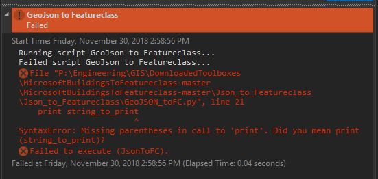
- Mark as New
- Bookmark
- Subscribe
- Mute
- Subscribe to RSS Feed
- Permalink
looks like that script was written for python 2.7 and it is being run in python 3.x since print is now a function and you need to enclose what you intend to print inside round brackets.. ie print(stuff) instead of print stuff
So either the script needs to be corrected or it needs to be run under a python 2.7 environment
- Mark as New
- Bookmark
- Subscribe
- Mute
- Subscribe to RSS Feed
- Permalink
I had a similar question, and posted on here this week.. but I just solved the issue!
I just successfully converted the New York State JSON file from Microsoft's GitHub downloads, using ArcGIS Pro 2.3 and it's "JSON To Features" Tool. I read somewhere in ESRI documentation that if the input is GeoJSON, not plain JSON, that you have to specify feature type: So I used this geoproc tool in the Python command window in Pro, not in the Toolbox, because the latter did not expose an option to select feature type.
A spot check of the resulting shapefile seems to suggest this worked great! 4,844,438 buildings resulted, and it didn't take THAT long considering (22 min)
Give it a try!
- Mark as New
- Bookmark
- Subscribe
- Mute
- Subscribe to RSS Feed
- Permalink
Thanks! This is another good resources, and easy way to browse the data!
In my case I wanted to download them because I have some additional uses for them, including trying to build them into viewshed analyses.(Yes I know that we don't have heights in most places on this data -- yet, but the footprints may still be useful with some assumptions built in)
- Mark as New
- Bookmark
- Subscribe
- Mute
- Subscribe to RSS Feed
- Permalink
I have them all as shapefiles for each state