- Home
- :
- All Communities
- :
- Products
- :
- Data Management
- :
- Data Management Questions
- :
- Re: clipping a polgyon layer with a polygon border...
- Subscribe to RSS Feed
- Mark Topic as New
- Mark Topic as Read
- Float this Topic for Current User
- Bookmark
- Subscribe
- Mute
- Printer Friendly Page
clipping a polgyon layer with a polygon border with geoprocessing Clip tool
- Mark as New
- Bookmark
- Subscribe
- Mute
- Subscribe to RSS Feed
- Permalink
- Report Inappropriate Content
When I did this, I had expected and hoped the new clipped polygon layer to have new empty polygons where there was a gap between the original parcel borders and the new outside clipping border. Instead, it ignored the clipping border and established the clip border at the original parcel outside borders.
Is there anyway to accomplish this as I had hoped and with a Standard License?
Solved! Go to Solution.
Accepted Solutions
- Mark as New
- Bookmark
- Subscribe
- Mute
- Subscribe to RSS Feed
- Permalink
- Report Inappropriate Content
If you have not already done this, what you can do is use the overlay tools to create the "empty polygons" where there is a gap between the expected extent and the existing polygon set for cases where the existing polygons. To do this, one would essentially do an process similar to the Erase geoprocessing tool. What the Erase geoprocessing tool does is takes one polygon layer and removes all the common area found between it and a second layer. The result is all the area that is not found in the second layer, which seems to be what you are looking for.

In your specific case, there is a catch, though. One needs to have an Advanced License level to be able to use the Erase geoprocessing tool, which you do not have. Thus the workaround process I posted the link for.
So how would all this work? In the process listed in the workaround, substitute your Clipping Boundary for all the places where they show "Input Features" and the existing parcels you have where they say "Erase Features", then follow all the process steps they list.
Note that your clipping boundary needs to be a polygon feature class. If it is not, depending upon what it is there are ways to convert it to a polygon feature class.
Chris Donohue, GISP
- Mark as New
- Bookmark
- Subscribe
- Mute
- Subscribe to RSS Feed
- Permalink
- Report Inappropriate Content
screen grab?
- Mark as New
- Bookmark
- Subscribe
- Mute
- Subscribe to RSS Feed
- Permalink
- Report Inappropriate Content
- Mark as New
- Bookmark
- Subscribe
- Mute
- Subscribe to RSS Feed
- Permalink
- Report Inappropriate Content
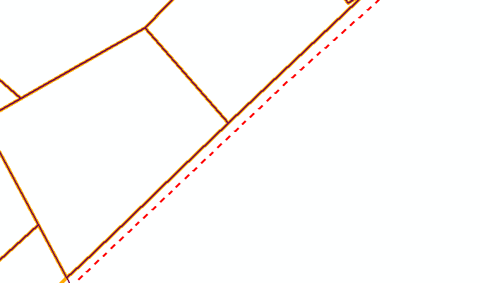
I can guess that the dashed line is the clipping feature? and that there was nothing to the south and east of it to clip, hence the gap. If you want something between the solid and dashed line other than nothing, then you have to use one of the 'overlay' tools in arctoolbox (perhaps union, but check the features in the arcmap help if that is what you are using)
- Mark as New
- Bookmark
- Subscribe
- Mute
- Subscribe to RSS Feed
- Permalink
- Report Inappropriate Content
Thanks, I'll try that out.
- Mark as New
- Bookmark
- Subscribe
- Mute
- Subscribe to RSS Feed
- Permalink
- Report Inappropriate Content
There are a variety of workarounds for situations like this. As Dan_Patterson mentioned this can be done with the overlay tools. Here is ESRI's solution on how to essentially do an "Erase" without access to the Erase geoprocessing tool (which requires an Advanced License)
How To: Remove overlapping areas of a polygon without using the Erase tool
Chris Donohue, GISP
- Mark as New
- Bookmark
- Subscribe
- Mute
- Subscribe to RSS Feed
- Permalink
- Report Inappropriate Content
Chris, I plan to check out the Overlay tools and specifically the Union tool that Dan mentioned. You mentioned and provided a link to the Erase workaround solution. Thanks for that.
I assume you were just providing this as additional information on the overall Overlay toolset, since this particular tool would not be helpful with my specific question and need.
- Mark as New
- Bookmark
- Subscribe
- Mute
- Subscribe to RSS Feed
- Permalink
- Report Inappropriate Content
If you have not already done this, what you can do is use the overlay tools to create the "empty polygons" where there is a gap between the expected extent and the existing polygon set for cases where the existing polygons. To do this, one would essentially do an process similar to the Erase geoprocessing tool. What the Erase geoprocessing tool does is takes one polygon layer and removes all the common area found between it and a second layer. The result is all the area that is not found in the second layer, which seems to be what you are looking for.
In your specific case, there is a catch, though. One needs to have an Advanced License level to be able to use the Erase geoprocessing tool, which you do not have. Thus the workaround process I posted the link for.
So how would all this work? In the process listed in the workaround, substitute your Clipping Boundary for all the places where they show "Input Features" and the existing parcels you have where they say "Erase Features", then follow all the process steps they list.
Note that your clipping boundary needs to be a polygon feature class. If it is not, depending upon what it is there are ways to convert it to a polygon feature class.
Chris Donohue, GISP
- Mark as New
- Bookmark
- Subscribe
- Mute
- Subscribe to RSS Feed
- Permalink
- Report Inappropriate Content
I tried your suggestion Chris and it worked as you described. I am now able to see all the gaps as polygons within the final Erase workaround output file. Thanks!