- Home
- :
- All Communities
- :
- Products
- :
- Data Management
- :
- Data Management Questions
- :
- Cleaning up polygon boundaries
- Subscribe to RSS Feed
- Mark Topic as New
- Mark Topic as Read
- Float this Topic for Current User
- Bookmark
- Subscribe
- Mute
- Printer Friendly Page
- Mark as New
- Bookmark
- Subscribe
- Mute
- Subscribe to RSS Feed
- Permalink
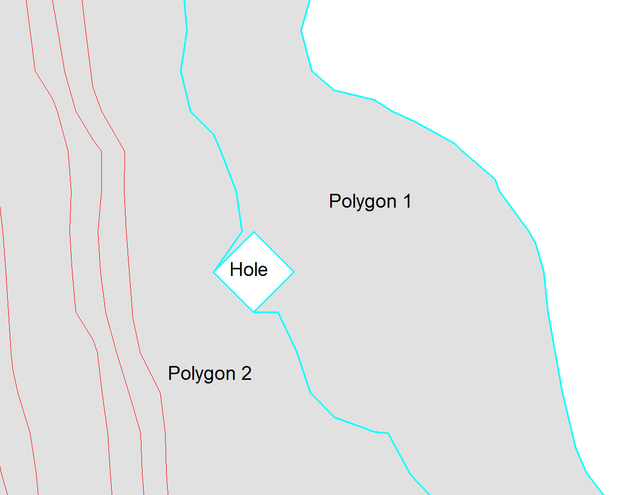
I'm having an issue with managing some data with errors in the polygon boundaries. The problem is that the software generating the data (delivered to me as Shape-files) will include some lines that are not the actual polygon boundary as part of the boundary. I'll try to show:

Above I have selected one of the problem polygons in ArcMap, Hereafter known as "Polygon 1". As you may see, there is a hole between Polygon 1 and Polygon 2. The south-western hole edge is part of the Polygon 2 boundary, while the other three side should form part of the Polygon 1 boundary.
The problem is that all the hole edges are included in the Polygon boundary, and this is causing problems later on when converting the data.
I have tried to Repair Geometry, but this only removes the hole and include the area into Polygon 1. Do anyone know a way clean up this ?
Solved! Go to Solution.
Accepted Solutions
- Mark as New
- Bookmark
- Subscribe
- Mute
- Subscribe to RSS Feed
- Permalink
Håvard,
Have you tried Creating a topology—Help | ArcGIS Desktop
Also refer:
An overview of topology in ArcGIS—Help | ArcGIS Desktop
Topology in ArcGIS—Help | ArcGIS Desktop
~Shan
~Shan
- Mark as New
- Bookmark
- Subscribe
- Mute
- Subscribe to RSS Feed
- Permalink
Hm... Might be helpful, but it seems to require a Data Reviewer license that I don't have.
I have access to Desktop 10.3.1 (up to advanced), but not many extensions (apart from 3D/spatial analyst).
- Mark as New
- Bookmark
- Subscribe
- Mute
- Subscribe to RSS Feed
- Permalink
Håvard,
Have you tried Creating a topology—Help | ArcGIS Desktop
Also refer:
An overview of topology in ArcGIS—Help | ArcGIS Desktop
Topology in ArcGIS—Help | ArcGIS Desktop
~Shan
~Shan
- Mark as New
- Bookmark
- Subscribe
- Mute
- Subscribe to RSS Feed
- Permalink
I had not. I haven't worked much with topologies before, but from what I can see this does exactly what I'm after.
- Mark as New
- Bookmark
- Subscribe
- Mute
- Subscribe to RSS Feed
- Permalink
Topology is usually the best method, but here is an additional option:
Integrate—Help | ArcGIS for Desktop
Note that this tool modifies the input data, so make a backup copy of the source data before running it.
Chris Donohue, GISP