Turn on suggestions
Auto-suggest helps you quickly narrow down your search results by suggesting possible matches as you type.
Cancel
- Home
- :
- All Communities
- :
- Products
- :
- Data Management
- :
- Data Management Questions
- :
- Re: Can't load rasters into Mosaic Dataset
Options
- Subscribe to RSS Feed
- Mark Topic as New
- Mark Topic as Read
- Float this Topic for Current User
- Bookmark
- Subscribe
- Mute
- Printer Friendly Page
Can't load rasters into Mosaic Dataset
Subscribe
2301
3
06-22-2011 07:45 PM
06-22-2011
07:45 PM
- Mark as New
- Bookmark
- Subscribe
- Mute
- Subscribe to RSS Feed
- Permalink
- Report Inappropriate Content
Hello,
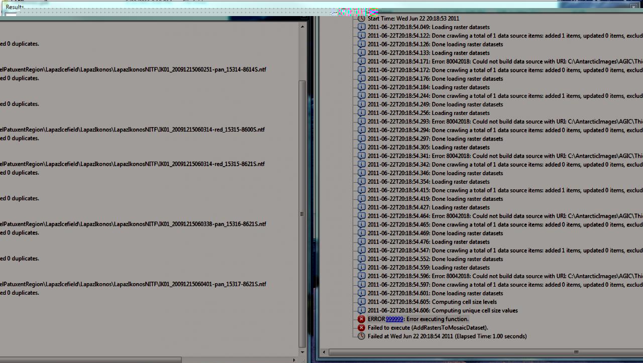
I am trying to create a Mosaic dataset. I try loading the rasters and consistently get the following error for each of the rasters being loaded:
Error 80042018: Could not build data source with the URI: C:\.......
See attached results log.
Any insight in helping resolve this issue would be appreciated.
Thanks much.
John Schutt
3 Replies
06-23-2011
10:58 AM
- Mark as New
- Bookmark
- Subscribe
- Mute
- Subscribe to RSS Feed
- Permalink
- Report Inappropriate Content
Hello,
After much gnashing of teeth and pulling of hair I determined that something had to be amiss with the NTF files and the way Arcgis was reading them. So I downloaded the free Opticks image processing program, imported each of the ntf files and then exported them back to a nft file. Brought them into Arcmap, but had to choose to stretch the images in order to run statistics to get them to display properly. But loaded the images ok into the mosaic dataset for a nice mosaic - except for the overlap/gaps. I ran the Define Mosaic Dataset No Value tool and chose 0 for black, but it only changed the overlap/gaps to white. See attached image. What am I missing here? Thanks for any help.
Cheers,
John Schutt
06-27-2011
10:26 AM
- Mark as New
- Bookmark
- Subscribe
- Mute
- Subscribe to RSS Feed
- Permalink
- Report Inappropriate Content
Just posted the following in another thread a few days ago, see if it solves your problem:
First, confirm that there is no gap in the source imagery. If at least one raster has a value where the output shows NODATA, it might be a matter of setting parameters in the tool.
The last two optional parameters are Mosaic Operator and Mosaic Colormap Mode. The default for the former is LAST, which gives the output the value of the last source raster that overlaps that cell. If this is NODATA, that will appear in the output. By changing this to MAXIMUM (or whatever suits your data best), NODATA values will be overridden by actual values in the output.
The same idea holds for the Mosaic Colormap Mode, but with options for a colormap instead of cell values.
06-27-2011
02:46 PM
- Mark as New
- Bookmark
- Subscribe
- Mute
- Subscribe to RSS Feed
- Permalink
- Report Inappropriate Content
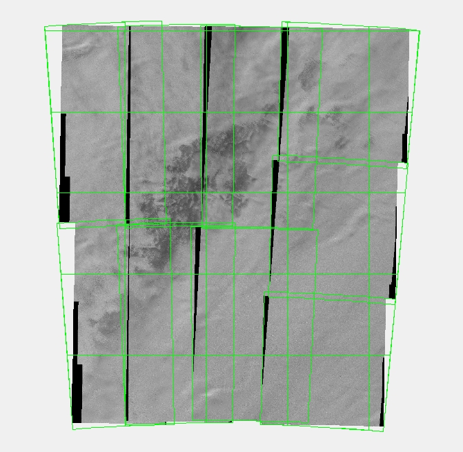
Thanks for the reply. Following the tutorials they make it seem so easy and problem free. Using my own data has been an exercise in frustration, to a large extent probably a result of my ignorance of the details in working with images and Arcgis. I came across the posting the other day and have been trying to make something work with the advice. Anyway, as you can see from the attached image that there are no gaps from the nine images that were loaded individually, then the background values set to 0 in the image layer properties for each one. I want to create seamless mosaics datasets of both the pan and multispectral raster datasets for the area. Some color balancing will be required, then I would like to pan sharpen the ms mosaic. But first I need get a seamless mosaic dataset without the No data/image overlaps displayed. The projection of the dataframe is the same as the projection defined in the Create Mosaic Dataset tool.
With the resulting mosaic dataset (see second attachment) I selected the mosaic Layer Properties-Mosaic tab and tried all sorts of combinations with the Mosaic Method and Mosaic Operator options based upon your suggestion, but nothing seems to happen and there is no change in the displayed image. I don�??t know if you can select those options using the Create Mosaic Dataset or the Add Rasters to Mosaic Dataset tools. I didn�??t see any way to do that. It seems like you should be able to though.
Thanks ,
John Schutt