- Home
- :
- All Communities
- :
- Products
- :
- Data Management
- :
- Data Management Questions
- :
- best way to convert a csv file with UTM to lat lon...
- Subscribe to RSS Feed
- Mark Topic as New
- Mark Topic as Read
- Float this Topic for Current User
- Bookmark
- Subscribe
- Mute
- Printer Friendly Page
best way to convert a csv file with UTM to lat long
- Mark as New
- Bookmark
- Subscribe
- Mute
- Subscribe to RSS Feed
- Permalink
I have a huge amount of .csv files each with hundreds of rows and each has its own value of an easting and northing
How can i quickly change these UTM coordinates and convert them to a lat/long coordinate value using ArcMap.
What might you suggest is the most efficient method? Im very new to this, so any help and details is greatly apprecaited
- Mark as New
- Bookmark
- Subscribe
- Mute
- Subscribe to RSS Feed
- Permalink
Thank you. Good luck on what your decision are...AND let us know what you have accomplish on this... 
- Mark as New
- Bookmark
- Subscribe
- Mute
- Subscribe to RSS Feed
- Permalink
im actually having a heck of a time, let me explain:
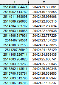
I was given an x value of (2514960.36447139) an a Y value of (2042479.38586146), Ok now when I set my layer properties to NAd83 Utm Zone 11, i then convert csv to events, i then convert to a shape file with the layers data frame, I now end up somewhere in mexico, this is the first issue.
- Mark as New
- Bookmark
- Subscribe
- Mute
- Subscribe to RSS Feed
- Permalink
It sounds like you got it right but you need to add the x and y columns and make them to longitude and latitude before you can convert to shapefile.
- Mark as New
- Bookmark
- Subscribe
- Mute
- Subscribe to RSS Feed
- Permalink
Does it appear in the correct place when you make your event layer?
- Mark as New
- Bookmark
- Subscribe
- Mute
- Subscribe to RSS Feed
- Permalink
No it doesnt here is what I was given it is not in mexico for sure
- Mark as New
- Bookmark
- Subscribe
- Mute
- Subscribe to RSS Feed
- Permalink
Then I guess your coordinates aren't in UTM Zone 11. Even if you switched the coordinates, it's still in Mexico.
- Mark as New
- Bookmark
- Subscribe
- Mute
- Subscribe to RSS Feed
- Permalink
hmmm, i need to convert these to lat/long it should be in canada above idaho.............eeeek
- Mark as New
- Bookmark
- Subscribe
- Mute
- Subscribe to RSS Feed
- Permalink
You can rule out these usual suspects:
BC Albers
Canada Albers
Canada Lambert
Alberta 10TM
Did you perhaps get these coordinates from a survey company, who like to confuse people by using a custom coordinate reference system?
- Mark as New
- Bookmark
- Subscribe
- Mute
- Subscribe to RSS Feed
- Permalink
no, supposedly they were converted from x,y coordinates to a NAD83 projection, then folks tinkered with them and exported them back to the values above, now they want it back on lat and long coords. I really have a great passion for GIS but this is making me nuts!!
when i put it i this handy dandy excel converter this is what i get

- Mark as New
- Bookmark
- Subscribe
- Mute
- Subscribe to RSS Feed
- Permalink
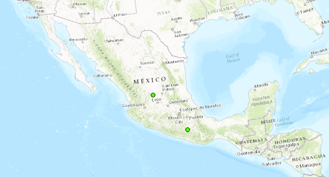
And, those lat/longs are in Mexico.
I would revisit this part, "then folks tinkered with them". The coordinates you have now are just not correct (at least, not for UTM Zone 11).