- Home
- :
- All Communities
- :
- Products
- :
- Data Management
- :
- Data Management Questions
- :
- best way to convert a csv file with UTM to lat lon...
- Subscribe to RSS Feed
- Mark Topic as New
- Mark Topic as Read
- Float this Topic for Current User
- Bookmark
- Subscribe
- Mute
- Printer Friendly Page
best way to convert a csv file with UTM to lat long
- Mark as New
- Bookmark
- Subscribe
- Mute
- Subscribe to RSS Feed
- Permalink
I have a huge amount of .csv files each with hundreds of rows and each has its own value of an easting and northing
How can i quickly change these UTM coordinates and convert them to a lat/long coordinate value using ArcMap.
What might you suggest is the most efficient method? Im very new to this, so any help and details is greatly apprecaited
- Mark as New
- Bookmark
- Subscribe
- Mute
- Subscribe to RSS Feed
- Permalink
try an online calculator just to confirm that the excel one returns correct values
- Mark as New
- Bookmark
- Subscribe
- Mute
- Subscribe to RSS Feed
- Permalink
The returned lat/longs are correct, or at least close enough to confirm they're in Mexico.
- Mark as New
- Bookmark
- Subscribe
- Mute
- Subscribe to RSS Feed
- Permalink
I always check conversions like this in my maps, and indeed i used different online converters to validate the calculations. So what have i learned, well bad data is bad data! the other files converted correctly, just a handful like this one appeared to be in the ocean or in mexico somewhere, fun times, i will follow up with you all when i get back in the office
thank you and I appreciate your assistance's, you are confirming im not losing my mind!!!
- Mark as New
- Bookmark
- Subscribe
- Mute
- Subscribe to RSS Feed
- Permalink
I was told it was from NAD83 utm11
- Mark as New
- Bookmark
- Subscribe
- Mute
- Subscribe to RSS Feed
- Permalink
Not even MTM, could be a local city... what is the latitude/longitude ? and is this data current or old (aka pre 1970's)
- Mark as New
- Bookmark
- Subscribe
- Mute
- Subscribe to RSS Feed
- Permalink
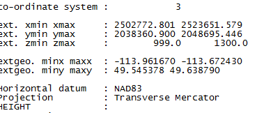
The X and the Y values are within the same range.
- The X coordinate should be in the range of 500,000 plus or minus a couple of hundred thousand if it was UTM, even if the coordinates were in feet, it is kind of stretching it that this would be UTM.
- The Y values... if it were in meters in the northern hemisphere would give it a position about 2/10 of the way from the equator to the north pole (ie about 18 degrees). If the coordinates were in feet, you would be closer to the equator.
Perhaps your coordinates are in meters, if so, then your projection is not a UTM but another projection that is used in your area.
- Mark as New
- Bookmark
- Subscribe
- Mute
- Subscribe to RSS Feed
- Permalink
Marina,
Those values don't look like UTM. If the data's in the US, they could be State Plane instead. If the data's scattered across, even a state (let alone multiple states), you may have to figure out which zone each one is in first. Ouch. UTM X coordinates should be between 200000 and 800000 meters, while in the contiguous US, Y values are between 2.5 million and 5.5 million meters. I didn't spot an obvious state plane zone that matched 2million,2million either.
If you can post approximately where the data is located, I can see if I can find a matching coordinate system. You can do this yourself by adding a base map/other data to ArcMap and setting the data frame's coordinate system to the one you want to check. Make sure the display units match the coordinate system and just read off the coordinates from the status bar (at bottom right of map).
EDIT: You said that the data's in Canada, above Idaho. Is it in BC or Alberta? We have a few provincial coordinate systems, but they're generally putting the data pretty far North. Nearest major feature?
Thanks!
Melita
- Mark as New
- Bookmark
- Subscribe
- Mute
- Subscribe to RSS Feed
- Permalink
I have a quick one question for you . Is there a website that you pulled it up like what Marina showed us the list of coordinates or a few of them to the one like that of Google Translate that can detect the projection quickly ?
- Mark as New
- Bookmark
- Subscribe
- Mute
- Subscribe to RSS Feed
- Permalink
The EPSG online registry website allow you to enter an extent and will then return any coordinate systems that match. But you then have to still check the parameters (mainly the false easting/northing ones) to see if the coordinates would match up.
- Mark as New
- Bookmark
- Subscribe
- Mute
- Subscribe to RSS Feed
- Permalink
it appears these coordinates should be 49 35 26.70 N, 113 57 36.93 W False easting meters, northing meters wth NAD83