- Home
- :
- All Communities
- :
- Products
- :
- Data Management
- :
- Data Management Questions
- :
- Re: Auto connect points with a line?
- Subscribe to RSS Feed
- Mark Topic as New
- Mark Topic as Read
- Float this Topic for Current User
- Bookmark
- Subscribe
- Mute
- Printer Friendly Page
- Mark as New
- Bookmark
- Subscribe
- Mute
- Subscribe to RSS Feed
- Permalink
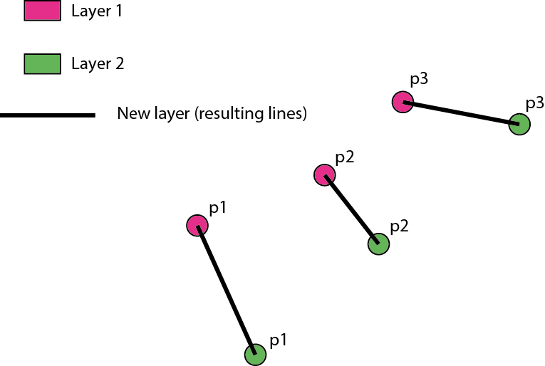
Need help to find out the best way to draw a line between points from different layers to show how the points have moved and save the line in a new layer.
Layer 1 - points that shows the positions hour 1.
Layer 2 - same points that shows the positions hour 2.
The points keep their ID in the attribute table.
Need a quick way to generate the lines as the data changes (eg. new layers are created)
Thanks!
Solved! Go to Solution.
Accepted Solutions
- Mark as New
- Bookmark
- Subscribe
- Mute
- Subscribe to RSS Feed
- Permalink
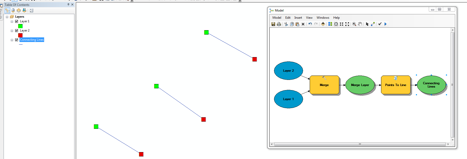
This should work. The merged layer can just be intermediate data. Ex:
- Mark as New
- Bookmark
- Subscribe
- Mute
- Subscribe to RSS Feed
- Permalink
Hi Daniel,
Take a look at the Points to Line tool. This may provide the solution you're looking for.
- Mark as New
- Bookmark
- Subscribe
- Mute
- Subscribe to RSS Feed
- Permalink
The points are in different layers and the output should be a layer with lines (keeping the ID as an identifier for the line). I can´t see how to use two layers as inputs in Points to Line tool.
- Mark as New
- Bookmark
- Subscribe
- Mute
- Subscribe to RSS Feed
- Permalink
Can you merge the two layers together and then execute the tool using the ID field? You can easily create a model that could automate this procedure.
- Mark as New
- Bookmark
- Subscribe
- Mute
- Subscribe to RSS Feed
- Permalink
Prefer to keep the existing layers (shape files) and only get the "line file". If I merge the data I need to create an identifier that tells the "time".
I´ll give it a try.
Thanks Jake
- Mark as New
- Bookmark
- Subscribe
- Mute
- Subscribe to RSS Feed
- Permalink
This should work. The merged layer can just be intermediate data. Ex:
- Mark as New
- Bookmark
- Subscribe
- Mute
- Subscribe to RSS Feed
- Permalink
If you're dead set against creating an intermediate feature class, you can do so using Python:
>>> points1 = 'Layer1' # input layer 1
... points2 = 'Layer2' # input layer 2
... sr = arcpy.Describe(points1).spatialReference # CRS of layer 1
... lines = [] # temp line list
... dict1 = {row[1]:row[0].centroid for row in arcpy.da.SearchCursor(points1,['SHAPE@','NAME'],spatial_reference=sr)} # load layer 1 to dictionary
... dict2 = {row[1]:row[0].centroid for row in arcpy.da.SearchCursor(points2,['SHAPE@','NAME'],spatial_reference=sr)} # load layer 2 to dictionary
... for k1,v1 in dict1.iteritems(): # loop dictionary 1
...    if k1 in dict2: # see if key exists in dictionary 2
...        new_line = arcpy.Polyline(arcpy.Array([v1,dict2[k1]]),sr) # create line
...        lines.append(new_line) # add to line list
... arcpy.CopyFeatures_management(lines,r'in_memory\lines') # write lines to feature class
- Mark as New
- Bookmark
- Subscribe
- Mute
- Subscribe to RSS Feed
- Permalink
Thanks Jake and Darren.
I had some problems that I did not understand at first. Got out bounds and som errors. The - cause - Point ZM. Used ET Wizards to save the data as regular points insted and the problems were gone.
(could the point ZM to point be done in the model with a ArcGIS Basic licens?)
The Python script will have to wait - one step at a time. 