- Home
- :
- All Communities
- :
- Products
- :
- Data Management
- :
- Data Management Questions
- :
- Assign coordinate reference of CAD file with no co...
- Subscribe to RSS Feed
- Mark Topic as New
- Mark Topic as Read
- Float this Topic for Current User
- Bookmark
- Subscribe
- Mute
- Printer Friendly Page
Assign coordinate reference of CAD file with no coordinate reference and no scale
- Mark as New
- Bookmark
- Subscribe
- Mute
- Subscribe to RSS Feed
- Permalink
Hi,
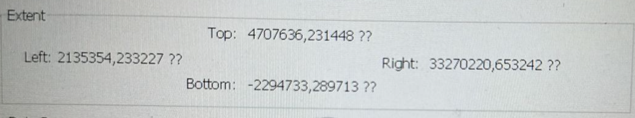
I have few CAD files that has no projection and there is a small word saying "no scale". You can find the extent on the attached file.
How do I :
1. See the projection used. Maybe by using autocad apps I am able to find out the coordinat reference
2. Guess scientifically about the coordinate reference
I have read this but I do not think its the same with my problem. Is it worth giving the coordinate reference without having scale ?
Thanks
- Mark as New
- Bookmark
- Subscribe
- Mute
- Subscribe to RSS Feed
- Permalink
I would guess that there is no way to find that out without being in contact with the person that created the CAD files. They can even use local coordinate systems, i.e. a non standard coordinate system that are not supported by ArcGIS.
If you know the location you can manually georeference the CAD files by using some data with a known coordinate system, e.g. imagery of the same building that your CAD file includes. Here is information about that workflow: Georeference CAD data—ArcGIS Pro | Documentation
- Mark as New
- Bookmark
- Subscribe
- Mute
- Subscribe to RSS Feed
- Permalink
Hi @AndreasHall ,
Fortunately I know the place. I will go with manual georeference as you suggested.
Thanks.