- Home
- :
- All Communities
- :
- Products
- :
- Data Management
- :
- Data Management Questions
- :
- Re: ArcMap Drawing errors
- Subscribe to RSS Feed
- Mark Topic as New
- Mark Topic as Read
- Float this Topic for Current User
- Bookmark
- Subscribe
- Mute
- Printer Friendly Page
ArcMap Drawing errors
- Mark as New
- Bookmark
- Subscribe
- Mute
- Subscribe to RSS Feed
- Permalink
HI,
Can anyone suggest how to resolve on below issue, snapshot attached.. is this possible to fix in the database.
This was in sde environment in the server. we are using oracle SQL developer for the database.

Thanks,
Srinivas
- Mark as New
- Bookmark
- Subscribe
- Mute
- Subscribe to RSS Feed
- Permalink
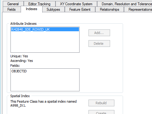
without more information this could be caused by many things. Is it registered to the EGDB and has it got a geometry field and spatial index?
- Mark as New
- Bookmark
- Subscribe
- Mute
- Subscribe to RSS Feed
- Permalink
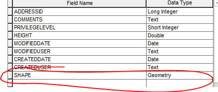
Yes, it is registered and it has got the geometry field and index was there.. any other solution to find out.
- Mark as New
- Bookmark
- Subscribe
- Mute
- Subscribe to RSS Feed
- Permalink
Was the spatial index built in SQL developer? In SQL developer, does the geometry metadata etc line-up with your projection and extent?
Can you read the table in SQL dev and ArcCatalog? and can you preview the geography in Catalog?
What's the history behind this feature, is it a new import, update, have you done something to it recently etc?
If you export the feature to a local FGDB as a FC does it work ok?
- Mark as New
- Bookmark
- Subscribe
- Mute
- Subscribe to RSS Feed
- Permalink
We are not a built-in SQL developer.
We can read the table in SQL dev and ArcCatalog. We cannot preview the geography in Catalog.
This feature was copied or import from the local file geodatabase and we have checked in FGDB that the feature is opening in ArcMap with geometry in local.
Yes, it does work when we export the feature to a local FGDB as it was seen in local.
- Mark as New
- Bookmark
- Subscribe
- Mute
- Subscribe to RSS Feed
- Permalink
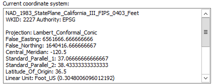
Whats the coordinate systems/projection? Copying to the sde may be using a configuration keyword or Default which is making funky geometry.
- Mark as New
- Bookmark
- Subscribe
- Mute
- Subscribe to RSS Feed
- Permalink
We have 86 layers, out of which 3 are having the same issue (ArcMap Layers, we deleted from sde and again imported, the same issue.
Also, the coordinate system/projection is as below.
- Mark as New
- Bookmark
- Subscribe
- Mute
- Subscribe to RSS Feed
- Permalink
What is the Geometry type (SDO_Geometry, ST_Geometry, etc.) being used in the feature classes with issues?
Is there multiple geometry types (point / line / poly) in the same table?
How are you importing the data into the Oracle Geodatabase?
- Mark as New
- Bookmark
- Subscribe
- Mute
- Subscribe to RSS Feed
- Permalink
Geometry type is Point.
No multiple geometries were available for the same table.
Manually importing or copying data to sde schema.
- Mark as New
- Bookmark
- Subscribe
- Mute
- Subscribe to RSS Feed
- Permalink
is the projection in the sde fc the same as that of the local fc.