- Home
- :
- All Communities
- :
- Products
- :
- Data Management
- :
- Data Management Questions
- :
- Re: arcgis make route event layer
- Subscribe to RSS Feed
- Mark Topic as New
- Mark Topic as Read
- Float this Topic for Current User
- Bookmark
- Subscribe
- Mute
- Printer Friendly Page
- Mark as New
- Bookmark
- Subscribe
- Mute
- Subscribe to RSS Feed
- Permalink
I want to place lines along an existing line. For that im using the tool 'make route event layer'. In the event table are my lines. The problem is that the lines with a length of 1 meter are not showing in ArcGIS (no shape length) and the lines with a length of 2 meter are showing. What goes wrong here and what do i have to change?
Solved! Go to Solution.
- Mark as New
- Bookmark
- Subscribe
- Mute
- Subscribe to RSS Feed
- Permalink
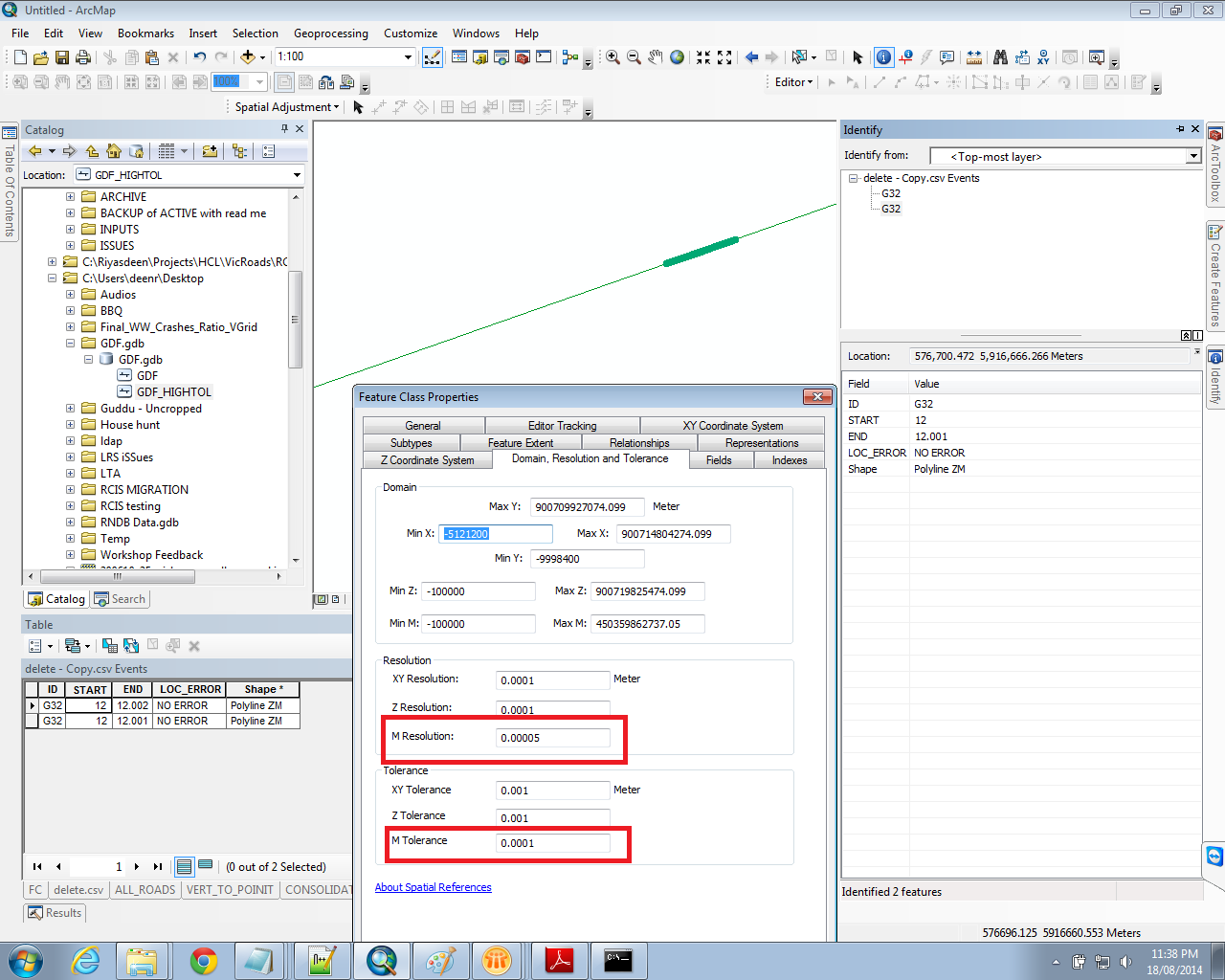
If your XY is in kilometers, what is the XY resolution and tolerance? It should be submeter levels also. Additionally, your routes are built in km, so your resolution is not .0001 meters, it is .0001 kilometers and the tolerance of .001 will control the length. M Resolution and tolerance are unitless and determined only after a route measure system is defined from whatever units you used. This setting means that if 2 measures are within .001 units of each other (no matter what type of units they represent) they are considered the same position and will be adjusted to eliminate one of the positions. If you really want km measures you need an M resolution of about .0000001 and a tolerance of .000001 for the measures to work to allow 1 meter lines (.001 measures) with reasonable submeter accuracy levels, unless you want really coarse measurements. .001 km is really coarse accuracy.
Alternatively remeasure all of your routes by converting the measure positions at every vertex multiplied by 1000 to convert the measures to meters. Then your M Resolution and Tolerance will behave as .0001 meter resolution and .001 meter tolerance. Of course then your event measures will also have to be multiplied by 1000 to match. It sounds like you just changed the event measures, which does no good if the routes are not remeasured to match.
- Mark as New
- Bookmark
- Subscribe
- Mute
- Subscribe to RSS Feed
- Permalink
When i see the GDF (line)-layer, the M-values are in km. I changed the M resolution and the M tolerance to 0.0000001 and still the 1 meter lines are not showing. I have tried already to change my values to metres but that wasnt working too. But its so strange that the 2 meter lines are showing because its only 1 meter difference.
Have you tried it by yourself? Maybe its ArcGIS that doesnt allow lines shorter as 2 metres?
- Mark as New
- Bookmark
- Subscribe
- Mute
- Subscribe to RSS Feed
- Permalink
Hi Maarten,
This is strange, Provided you are getting 'zero length extent' error, I would have expected Richard's suggestions would have fixed your issue.
Can you update your line feature with attributes stripped out, that will help in identifying or reproducing the issue rather than speculating.
- Mark as New
- Bookmark
- Subscribe
- Mute
- Subscribe to RSS Feed
- Permalink
Sorry that was upload (Share) not update.
- Mark as New
- Bookmark
- Subscribe
- Mute
- Subscribe to RSS Feed
- Permalink
What do you mean bij upload the line feature? I cant send it to you via this way?
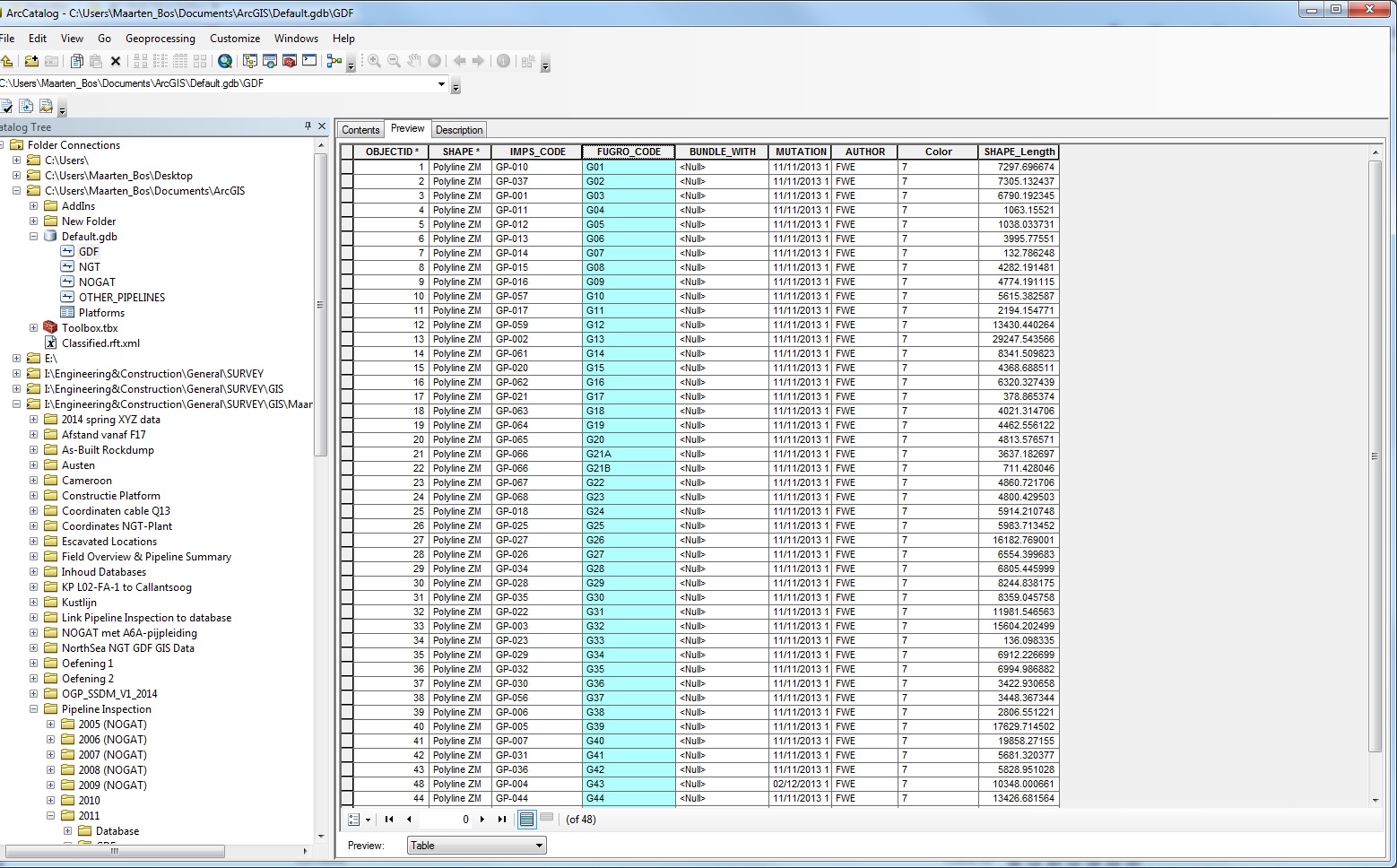
Here is the linefeature with the pipelines. I connect my table with the attribute FUGROCODE.
- Mark as New
- Bookmark
- Subscribe
- Mute
- Subscribe to RSS Feed
- Permalink
Can try using Upload file in forum? it'll be next to your profile icon or uploading in any public file sharing web site.
- Mark as New
- Bookmark
- Subscribe
- Mute
- Subscribe to RSS Feed
- Permalink
Hey Riyas, I have uploaded the feature class here. I hope you can find the problem. I really appreciate that you (and the rest of the people) help me!
- Mark as New
- Bookmark
- Subscribe
- Mute
- Subscribe to RSS Feed
- Permalink
Hi Maarten,
Found your 1 meter segment.
This is what i did.
- Created another feature class with M Tolerance 0.0001
- Appended your features to my new feature class
- Created a route event layer.
- There it is your 1 meter segment.
- Mark as New
- Bookmark
- Subscribe
- Mute
- Subscribe to RSS Feed
- Permalink
Hey Riyas,
Im really grateful too you! But do you know how you can append my features in the new feature class without losing the attributes like FUGRO_CODE? With datamanagement-append i put the new feature class as input. The existing feature class as the target layer. At schematyp i put no_ so you can use fieldmap. What do i have to do more?
xx Maarten
- Mark as New
- Bookmark
- Subscribe
- Mute
- Subscribe to RSS Feed
- Permalink
When creating your new feature class you should import the fields from your existing feature class.
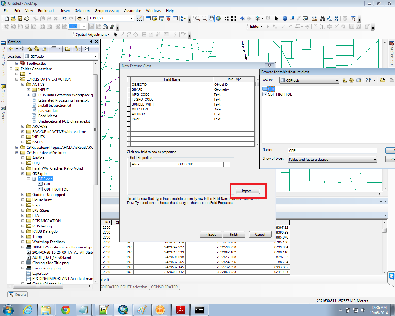
And of course when appending your features Schema Type should be NO_TEST.
Please mark this discussion as answered, I'm sure there are other people who might have similar issues with linear referencing.