- Home
- :
- All Communities
- :
- Products
- :
- Data Management
- :
- Data Management Questions
- :
- Re: ArcGIS 10.2.2: Adding field with unwanted effe...
- Subscribe to RSS Feed
- Mark Topic as New
- Mark Topic as Read
- Float this Topic for Current User
- Bookmark
- Subscribe
- Mute
- Printer Friendly Page
ArcGIS 10.2.2: Adding field with unwanted effects
- Mark as New
- Bookmark
- Subscribe
- Mute
- Subscribe to RSS Feed
- Permalink
Hello,
I've got a shapefile with different information in the attribute table. When I add a new field to the table in every field there will be added a space character in front of the entry. In addition to this some of the fields get new values and the new added field will be filled with values without having set a default value.
I got a intricated solution by exporting the shapefile in ArcMap to a new shapefile.
But does anyone know the reason for this behaviour?
Solved! Go to Solution.
Accepted Solutions
- Mark as New
- Bookmark
- Subscribe
- Mute
- Subscribe to RSS Feed
- Permalink
Both Dan Patterson and Kyle Balke, GISP have important points on what may be causing the unexpected behavior. It may be that you are trying to edit your shapefile outside the established methods, which is why it is not working correctly. Can you elaborate on the specific processes you are doing to make the changes to your shapefile?
It would be best to ensure the process you are using is viable, as there are some processes people use that seem like they would work but actually have negative consequences. For example, editing a shapefile attributes using Excel to change the values in the .dbf part of the shapefile - that is NOT a valid method, as it does not update the linkages between the table (.dbf) and the spatial index (.shx). However, it is easy to assume since one can open the dbf in Excel that this is OK.
Also, the link below may prove helpful to recover files that are already showing unexpected behavior (though you probably want to figure out why they are getting corrupted first).
Recovering a corrupt shapefile:
27429 - Recover a corrupt shapefile
Chris Donohue, GISP
- Mark as New
- Bookmark
- Subscribe
- Mute
- Subscribe to RSS Feed
- Permalink
Can you show a screen grab of what you mean? This behaviour is not normal. Also, what type of fields are you adding? text, numeric?
- Mark as New
- Bookmark
- Subscribe
- Mute
- Subscribe to RSS Feed
- Permalink
Below you find the normal structure of the shapefile.
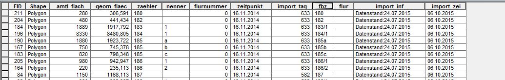
I'm adding a text-field "fbz_neu" with 50 characters. The result of the unwantedt behaviour can be seen below.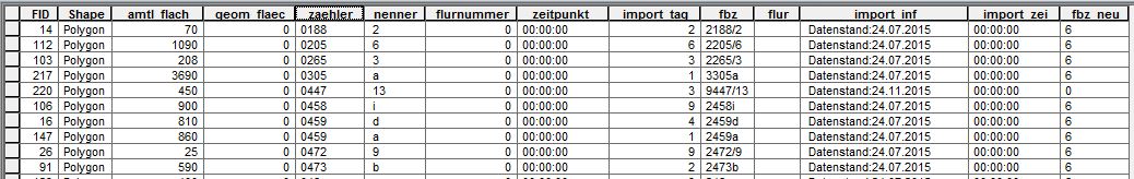
It's not just filling the field "fbz_neu" with unwanted numbers, it also changes entries f.e. "geom_flaec". Unfortunately I find out that the fields "zaehler" and "nenner" had been modified catastrophically.
- Mark as New
- Bookmark
- Subscribe
- Mute
- Subscribe to RSS Feed
- Permalink
Why are the values in the FID field unordered? Are you sorting then doing some form of calculation?
- Mark as New
- Bookmark
- Subscribe
- Mute
- Subscribe to RSS Feed
- Permalink
Are you calculating the new field in ArcMap or trying to modify the underlying .dbf?
- Mark as New
- Bookmark
- Subscribe
- Mute
- Subscribe to RSS Feed
- Permalink
I'm seeing some of the impacts. All the values in the field geom_fleec became zero. zeopunkt and import_zei likewise got zeroed out.
This is definitely odd behavior. Just curious - any idea where shapefile came from? Any chance it was a non-GIS application that created it? Some applications output shapefiles, but not to the full standard that is used in GIS.
Maybe also the shapefile, irrespective of its source, got corrupted?
You may also want to consider moving the data to a File Geodatabase, which tends to be more stable.
Chris Donohue, GISP
- Mark as New
- Bookmark
- Subscribe
- Mute
- Subscribe to RSS Feed
- Permalink
Agreed on moving to File Geodatabase to see if this resolves the issues.
- Mark as New
- Bookmark
- Subscribe
- Mute
- Subscribe to RSS Feed
- Permalink
Both Dan Patterson and Kyle Balke, GISP have important points on what may be causing the unexpected behavior. It may be that you are trying to edit your shapefile outside the established methods, which is why it is not working correctly. Can you elaborate on the specific processes you are doing to make the changes to your shapefile?
It would be best to ensure the process you are using is viable, as there are some processes people use that seem like they would work but actually have negative consequences. For example, editing a shapefile attributes using Excel to change the values in the .dbf part of the shapefile - that is NOT a valid method, as it does not update the linkages between the table (.dbf) and the spatial index (.shx). However, it is easy to assume since one can open the dbf in Excel that this is OK.
Also, the link below may prove helpful to recover files that are already showing unexpected behavior (though you probably want to figure out why they are getting corrupted first).
Recovering a corrupt shapefile:
27429 - Recover a corrupt shapefile
Chris Donohue, GISP