- Home
- :
- All Communities
- :
- Industries
- :
- State & Local Government
- :
- Community Development
- :
- Community Development Questions
- :
- Re: Move verticies at intersection of lines in Arc...
- Subscribe to RSS Feed
- Mark Topic as New
- Mark Topic as Read
- Float this Topic for Current User
- Bookmark
- Subscribe
- Mute
- Printer Friendly Page
Move verticies at intersection of lines in ArcPro
- Mark as New
- Bookmark
- Subscribe
- Mute
- Subscribe to RSS Feed
- Permalink
Hello!
I am working with a county-wide road centerlines dataset and we need to be able to:
-Edit existing road centerline features while preserving attributes
-Create a dataset free from dangles (where appropriate).
So my question is: In places where multiple roads come together we need to be able to modify geometry without unsnapping the roads. These might be snapped endpoint to edge, endpoint to endpoint, midpoint to midpoint, etc. There is some functionality using the Move - edges tool but that moves much more than a few verticies and is often too coarse for our purposes. If I try the same thing with Modify Verticies - edges it does not seem to be able to handle intersecting lines.
Is there a way to modify the location of a snapped point that does not modify the rest of the geometry? Similar to how geometric networks work in ArcMap? We do not currently have the capability to use utility networks since they require an enterprise GDB.
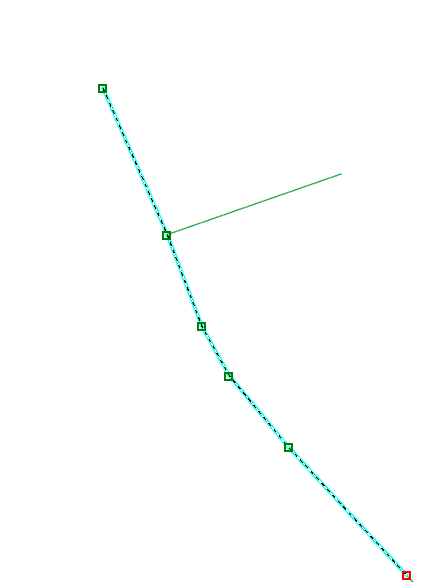
In the below images is an example of the kinds of areas I am talking about. Location of only one vertex needs to be changed.
- Mark as New
- Bookmark
- Subscribe
- Mute
- Subscribe to RSS Feed
- Permalink
For dangles, you'll want to use a topology, but a straight out of the box 'Must Not Have Dangles' rule will make you crazy when it comes to cul-d-sacs. Take a look at this post from friend and colleague Tim Witt. I used the original add-in and it worked great!
As far as editing roads as per your illustrations: get ready to roll you sleeves up and get your hands dirty. It's a boat load of work, but the end result will be worth it. Personally for roads, I'm not a fan of anything but true intersections with a couple of exceptions, and this is based on my work in 9-1-1 dispatch.
I routed response vehicles across my centerline data and used intersections only rather than vertex: There is a lot of data out there that evolved from the old ESRI Coverage model where anytime one line crossed another there was an intersection. Consider the case where a surface street over-passes a freeway or other limited access highway. In the coverage model, there was an intersection where they crossed. Fast forward to the Geodatabase model; that same data may or may not represent that line crossing as an intersection; it may represent it as coincident vertexes. Image my chagrin if I allowed a route to follow vertexes instead of true intersections and routed a fire truck off an overpass to the underlying freeway...
However, in the street centerline feature class we included several pedestrian only trails. For 9-1-1 dispatch purposes I couldn't route a vehicle down a trail, but if someone else wanted to use the data for a walking network, there needs to be connectivity. I added a vertex on the street, and snapped the trail to it: connectivity, but not route enabled for my purposes. (Since I was the manager of the data, I got to set the rules of the game...)
Hope this helps-
- Mark as New
- Bookmark
- Subscribe
- Mute
- Subscribe to RSS Feed
- Permalink
Thanks so much! To clarify:
-What do you mean by true intersections? Is there an option to add intersection in arc? (I haven't found one but that doesn't mean it doesn't exist!)
-Were you edit geometry in intersections (particularly T intersections, or ones where at least one line did not continue) while keeping everything snapped together still?
- Mark as New
- Bookmark
- Subscribe
- Mute
- Subscribe to RSS Feed
- Permalink
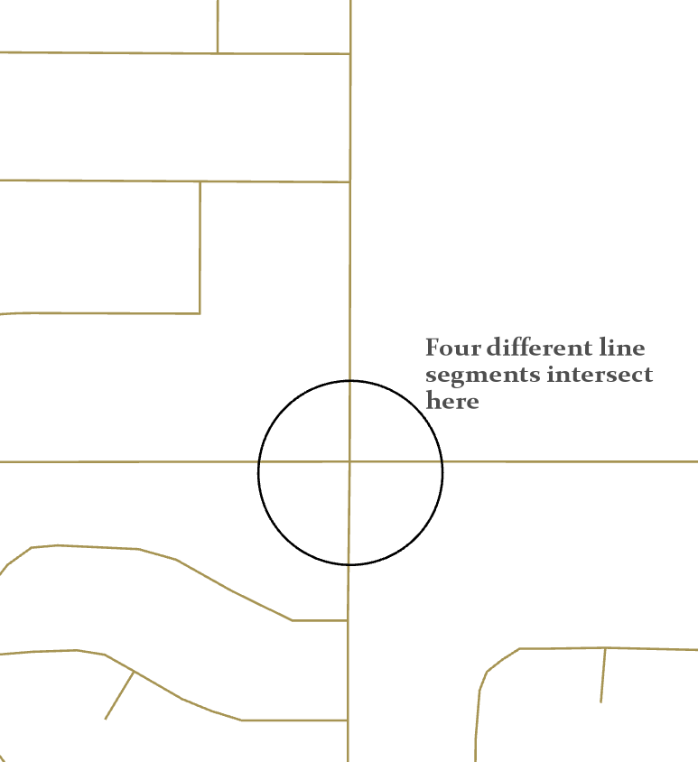
An intersection is where more than one individual line segments come together, and their begin/end nodes are spatially coincident. Note that an intersection may 'look like' a single street. Consider when a street passes from one jurisdiction to another. It may change name. It may adopt a new address system. At the very least, it changes jurisdiction, which, depending on how you model your data, may require you to split the single line to accommodate the change(s).
With snapping turned on, you avoid gaps and under/overshoots when you digitize lines you want to intersect. If you are going to create a street centerlines feature class, you should consider different uses of the data. As mentioned, I used them in 9-1-1, but a colleague may be a pavement management guy and another may just want to make maps with the data. A solid centerlines feature class is a valuable piece of data for any county.
- Mark as New
- Bookmark
- Subscribe
- Mute
- Subscribe to RSS Feed
- Permalink
Gotcha! So it's not a special variety of node in ArcGIS? Just the way that the segments are constructed?
Do you have a way to move all of those end/start points at once (like in a geometric network) in ArcPro? We want to be able to move multiple verticies at one from difference features, it's proving more complicated than it seems like it should be.
- Mark as New
- Bookmark
- Subscribe
- Mute
- Subscribe to RSS Feed
- Permalink
...So it's not a special variety of node... Not sure what you are asking: all polylines have a begin and end node and anything in between is a vertex.
I'm not aware of any way to move multiple nodes at once or multiple vertices; that doesn't mean there isn't a way though. I guess you could turn your street network into a geometric network for editing purposes if you want/need that ability.
- Mark as New
- Bookmark
- Subscribe
- Mute
- Subscribe to RSS Feed
- Permalink
Sorry for the confusion. I mean there's not special "right click to add intersection" or something like it that behaves differently than if we were just to have snapped endpoints? Sounds like not.
Yeah, a geometric network is the closest thing I've found to what we need. We don't have enterprise GDB capabilities so Utility Network isnt an option. We have been on pro for a few years so it will be interesting to train the techs back into ArcMap! Geometric network seems a little clunky but less clunky than some other options.
- Mark as New
- Bookmark
- Subscribe
- Mute
- Subscribe to RSS Feed
- Permalink
"right click to add intersection" If you have two lines you would like to intersect, simply split the one that needs. In the screen capture below, I have a line that is joined to the selected line at a vertex of the selected line. If I wanted a true intersection, I would split the selected line at that vertex ending up with two segments with identical attributes. In the case of street centerlines you would need to adjust the address ranges on those two segments.