- Home
- :
- All Communities
- :
- Products
- :
- ArcPad
- :
- ArcPad Questions
- :
- Recording (HRMS, VRMS, PDOP, Num of sats) in SHP
- Subscribe to RSS Feed
- Mark Topic as New
- Mark Topic as Read
- Float this Topic for Current User
- Bookmark
- Subscribe
- Mute
- Printer Friendly Page
Recording (HRMS, VRMS, PDOP, Num of sats) in SHP
- Mark as New
- Bookmark
- Subscribe
- Mute
- Subscribe to RSS Feed
- Permalink
- Report Inappropriate Content
I'm using ArcPad v10.0 with a Network RTK receiver. Is there a way to record the GPS quality information (HRMS, VRMS, PDOP, Num of sats) as attributes in a shapefile or in separate log file so that it is linked to measured points (maybe a log NMEA output)?
I'm looking for the points in my shapefile to have this information in them. The GPS Status window shows this info so I assume it should be accessible to record. Has anyone had any experience with this?
Thanks for your help!
- Mark as New
- Bookmark
- Subscribe
- Mute
- Subscribe to RSS Feed
- Permalink
- Report Inappropriate Content
ArcPad 10.0.4 release adds support for $GPGST (GNSS pseudorange error statistics and position accuracy) NMEA sentence and is used to populate the EPE, HPE and VPE fields in the GPS position windows quality tab when available. $GPGST sentence includes 'RMS deviation' field which is the total RMS standard deviation of ranges inputs to the navigation solution. In addition, you can use Add XYZ+ values to table ArcScripts sample to record GPS quality information as attributes in ArcPad feature layer. Currently supported fields are X or LATITUDE, Y or LONGITUDE, Z or ALTITUDE, PDOP, NUM_SATS, GPS_TIME, GPS_DATE, QUALITY, DGPS_ID, DIFF_AGE, HDOP, EPE, HPE, LENGTH (for Polyline) and AREA (for Polygon) datasets. You will need to modify the sample in order to record the RMS (HRMS, VRMS) values as attributes in ArcPad feature layer.
Cheers,
Denise
- Mark as New
- Bookmark
- Subscribe
- Mute
- Subscribe to RSS Feed
- Permalink
- Report Inappropriate Content
Anyone please let me know if you have been successful in getting this applet to work. I am utilizing a Leica Zeno device running ArcPad (Zeno Field) and Zeno Office on ArcMap on a desktop.
I've tried this many times, also with a network RTK unit running ArcPad. When the script populates the various coordinate quality fields and it does not appear to be in any sort of measurable unit.
The applet will provide DOP’s (HDOP, GDOP, etc.) but these are not useful. We need a unit of measure of statistical error approximation.
We need to be able to provide a standard deviation or coordinate quality in meters or feet.
Example: 0.02ft horizontal, 0.04ft vertical, 0.06ft 3DCDQ.
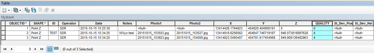
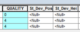
The XYZ applet populates the QUALITY field, but it doesn’t seem to have any unit to it, no matter if it is set up as a text or numerical field. It’s either 0,1 or 4. I don’t know what these numbers relate to. I cannot figure any type of conversion from this to coordinate quality in 1D, 2D, or 3D, in any particular unit of measure. See Point Feature Attribute Table and corresponding Point Details shown below. If you are aware of anyone successfully utilizing the XYZ applet to get a coordinate quality, please let me know how they are doing it.
Attribute Table:
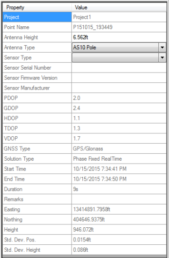
GNSS Point Details - As you can see here at the bottom of the point details, the XYZ Applet should be showing Qualities of 2D=0.015ft, 1D=0.086 or a 3D or approximately 0.11ft.
- Mark as New
- Bookmark
- Subscribe
- Mute
- Subscribe to RSS Feed
- Permalink
- Report Inappropriate Content
Well I read a little further on the XYZ applet...... Not sure if this will work for me since it says for Garmin GPS only.
"EPE" Estimated position error of the GPS (for Garmin® GPS receivers only). Double
"HDOP" Horizontal dilution of precision of the GPS. Double
"HPE" Horizontal position error of the GPS (for Garmin® GPS receivers only). Double
"PDOP" Position dilution of precision of the GPS. Double
"SATS_USED" Number of satellites used for the current position. Long
"QUALITY" GPS fix quality Long - 0 = Invalid- 1 = GPS fix- 2 = DGPS fix
"DIFF_AGE" Age of the current differential signal (in seconds) Long
"DIFF_ID" ID of the DGPS station used. Long
- Mark as New
- Bookmark
- Subscribe
- Mute
- Subscribe to RSS Feed
- Permalink
- Report Inappropriate Content
Hello all,
As of ArcPad 10.2, you are also able to use QuickFields to auto populate GPS info into your data.
Please see here for more information about QuickFields: ArcPad Help
The GPS options available in Quick Fields is as follows:
- Hannah
- Mark as New
- Bookmark
- Subscribe
- Mute
- Subscribe to RSS Feed
- Permalink
- Report Inappropriate Content
What version of ArcPad are you using? I cannot get the XYZ Applet to work on 10.2, I tried on multiple devices.
I'm trying to use quick fields also, but that is coming up short because help provides limited information on the syntax. I also don't like the idea of something that can be turned off.