- Home
- :
- All Communities
- :
- Products
- :
- ArcMap (Retired)
- :
- ArcMap Questions
- :
- Re: Viewing attribute table for Grid raster
- Subscribe to RSS Feed
- Mark Topic as New
- Mark Topic as Read
- Float this Topic for Current User
- Bookmark
- Subscribe
- Mute
- Printer Friendly Page
Viewing attribute table for Grid raster
- Mark as New
- Bookmark
- Subscribe
- Mute
- Subscribe to RSS Feed
- Permalink
I have a raster in ESRI Grid format and am trying to view the attribute table in my student version of ArcMap 10.5. I know this raster has fields attached to it because I am able to view the attribute table on another machine running ArcMap 10.5.1 (see attached screenshot). However, on my machine, when I right click the raster in Table of Contents, the option to Open Attribute Table is grayed out. I have Spatial Analyst enabled on my machine, but is there some other setting I should look into, or a restriction with my student license? My ultimate goal is to use the Lookup Tool to produce rasters based on the attribute fields, which I was able to do successfully on the other machine. I have the exact same files for the raster on my machine.
.png)
- Mark as New
- Bookmark
- Subscribe
- Mute
- Subscribe to RSS Feed
- Permalink
I suspect that you have too many classes for your machine's setup.
You can try the
Advanced ArcMap Settings utility—Help | ArcGIS Desktop
to set it to a higher value for the raster table
- Mark as New
- Bookmark
- Subscribe
- Mute
- Subscribe to RSS Feed
- Permalink
Thank you! I was sure that this was the problem, because when I opened the Advanced Settings Utility, the number of classes was set to 25 and my raster has >100. I changed it to the maximum (256, see screenshot). However, I am still not able to view the attribute table. I increased the number of classes and made sure that the number of table entries does not exceed the settings. I have restarted ArcMap after applying these settings and even restarted my computer. Any idea if there is another step I need to do?
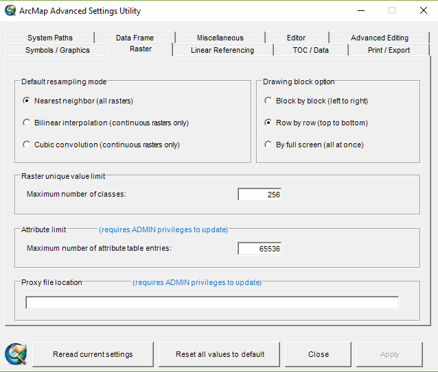
.png)
- Mark as New
- Bookmark
- Subscribe
- Mute
- Subscribe to RSS Feed
- Permalink
you didn't change the attribute entries... check to see on the other machine how many rows there are in that table.
- Mark as New
- Bookmark
- Subscribe
- Mute
- Subscribe to RSS Feed
- Permalink
There are about 30000 rows, well within the limit. I also realized that the first setting is changing the number of classes allowed, not fields, so I don't think that is my problem after all. I checked the Advanced Settings Utility on the other machine and it just had the default of 25, yet I could view the attribute table.
- Mark as New
- Bookmark
- Subscribe
- Mute
- Subscribe to RSS Feed
- Permalink
Cara
Say the ESRI grid is called mygrid and it is located in c:\temp
Using Windows Explorer navigate to c:\temp\mygrid
Do you see a file called vat.adf?
and I presume that this grid is stored locally on your computer?
Thanks
-Steve
- Mark as New
- Bookmark
- Subscribe
- Mute
- Subscribe to RSS Feed
- Permalink
Thanks for the reply. I think you have inadvertently solved my problem! I went to double-check on the file location, which was on my 😧 drive. Out of curiosity, I moved it to my C: drive. Now I can view the attributes! Any idea why it would not work from the 😧 drive?
Cara
- Mark as New
- Bookmark
- Subscribe
- Mute
- Subscribe to RSS Feed
- Permalink
is D a 'real drive' (ie internal to your computer) or a usb/flash drive? my students have no end of problems using usb drives for some reason... so much so, we banish them except for backups at the end of the day
- Mark as New
- Bookmark
- Subscribe
- Mute
- Subscribe to RSS Feed
- Permalink
It is an internal drive on my computer, and I store a lot of my GIS data
there, but I will be reconsidering that if I have any more problems! Thanks
again for the help.