- Home
- :
- All Communities
- :
- Products
- :
- ArcMap
- :
- ArcMap Questions
- :
- Re: Interpreting Level of Detail for creating Tile...
- Subscribe to RSS Feed
- Mark Topic as New
- Mark Topic as Read
- Float this Topic for Current User
- Bookmark
- Subscribe
- Mute
- Printer Friendly Page
Interpreting Level of Detail for creating Tile Packages
- Mark as New
- Bookmark
- Subscribe
- Mute
- Subscribe to RSS Feed
- Permalink
Hi all,
I am attempting to create a tile package of a raster mosaic and continue to encounter a perplexing concept that I'm not quite sure how to interpret.
Level of Detail (as far as I know) in the Create Tile Package tool corresponds to zoom level and not scale, so when creating my tile package I'm not quite sure what minimum (1) or maximum (24) relates to exactly.
Is 1 the most zoomed out, i.e. the raster's zoom level at full extent? Or just how the image displays at its current level in the Data View? So if I were to use the standard Fixed Zoom In tool in my MXD 24 times (regardless of the starting scale), at 24 "zoom-ins" that would be the max detail in the final tile package?
Any explanation would help, as I haven't found a clear enough answer for myself yet. It's important for me to really know what the end result of detail will show in the raster - preferably before I run the packaging tool.
Thanks!
Solved! Go to Solution.
Accepted Solutions
- Mark as New
- Bookmark
- Subscribe
- Mute
- Subscribe to RSS Feed
- Permalink
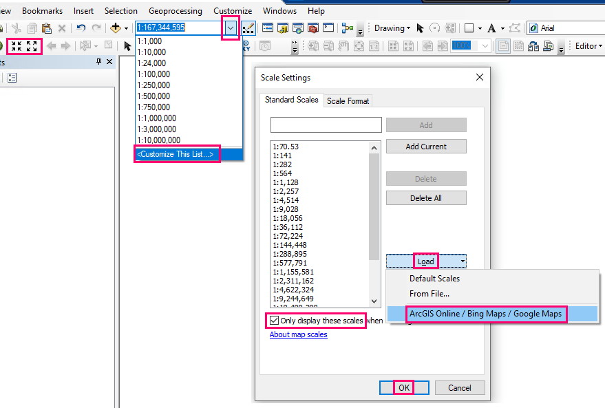
Each zoom level does have a scale. Since you are talking about zoom level 24, I presume you are using the standard ArcGIS Online\Bing\Google tiling scheme. There is an easy to set this up in ArcMap to make it clearer.
Click the drop down arrow in the scales box in the toolbar and choose Customize This List. Click on Load and choose ArcGIS Online. Tick the box marked Only display these scales. Now your scale chooser will have the full list of the zoom level scales. When you click the zoom in button once it will go to the next zoom\scale level. So zoom level 0 is 1:591,657,528 and zoom level 23 is 1:70.53
- Mark as New
- Bookmark
- Subscribe
- Mute
- Subscribe to RSS Feed
- Permalink
Thank you Tim, that's perfect - just the clarification I needed!