- Home
- :
- All Communities
- :
- Products
- :
- ArcGIS Web AppBuilder
- :
- ArcGIS Web AppBuilder Questions
- :
- Re: Layer not showing up in print
- Subscribe to RSS Feed
- Mark Topic as New
- Mark Topic as Read
- Float this Topic for Current User
- Bookmark
- Subscribe
- Mute
- Printer Friendly Page
- Mark as New
- Bookmark
- Subscribe
- Mute
- Subscribe to RSS Feed
- Permalink
Web link: ArcGIS Web Application
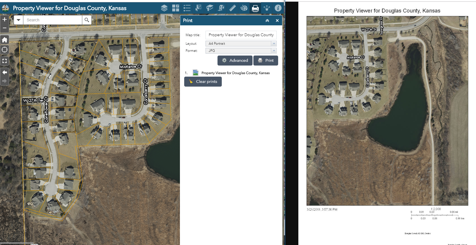
I've "upgraded" a few of my maps to WABDE ver 2.11, and am having an issue with the Print widget. Everything appears to work fine, but when the actual JPG/PDF/PNG is created, the parcel layer does not show up. This layer is visible in the map (you have to zoom in a bit to see the orange property lines) and it appears in the Legend widget. Is this a bug or (more likely) am I missing a setting somewhere in my web map?
Screen shot --
Solved! Go to Solution.
Accepted Solutions
- Mark as New
- Bookmark
- Subscribe
- Mute
- Subscribe to RSS Feed
- Permalink
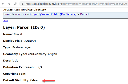
unfortunately you are running into a bug where print service fails to draw a feature layer when its default visibility is False in the map/feature service.
good news is that this is fixed in 10.7.
until you migrate to 10.7, you can go with one of the following options:
1. make the Parcel layer visible in your map and republish the map service
2. add your service as a mapImage layer (aka dynamic map service layer where the url ends with '/MapServer') instead of a feature layer (where url ends with '/MapServer/<id>')
hope this helps.
- Mark as New
- Bookmark
- Subscribe
- Mute
- Subscribe to RSS Feed
- Permalink
@TanuHoque I am having this issue, on 10.7.1. Are there new solutions these days?? Thanks!!
Esri Default Printing Tool in Print Widget in WAB works and displays parcels
Utility Printing Tool from stand alone server deployment (identical to Esri default??) distorts basemap and removes parcels.
Custom Printing Tool from Pro 2.9 layout template published in 3.0.3 with 10.7.1 also distorts basemap and removes parcels.


Olmsted County GIS
GIS Analyst - GIS Solutions
- Mark as New
- Bookmark
- Subscribe
- Mute
- Subscribe to RSS Feed
- Permalink
I don't think the issue that you are running into is same as the original issue mentioned above. But I could be wrong.
That said, since you mentioned "Esri Default Printing Tool in Print Widget in WAB works and displays parcels", I think you problem will be resolved when you move to a new server version. Esri default print service is running on a 11.0 server.
here is the url to that service: https://utility.arcgisonline.com/arcgis/rest/services/Utilities/PrintingTools/GPServer
- Mark as New
- Bookmark
- Subscribe
- Mute
- Subscribe to RSS Feed
- Permalink
@TanuHoque The saddest news. I wish we could! Someday.... my org admins, very slow movers.
Know if there's anyway to sort of figure out if it's simply the server and not some other random thing I'm doing incorrectly? Or is that more of an Esri support question?
Olmsted County GIS
GIS Analyst - GIS Solutions
- Mark as New
- Bookmark
- Subscribe
- Mute
- Subscribe to RSS Feed
- Permalink
Unfortunately it is hard to determine that here. Please contact Esri support. And they should be able to help...