- Home
- :
- All Communities
- :
- Products
- :
- ArcGIS Survey123
- :
- ArcGIS Survey123 Questions
- :
- Re: Using more than one geopoint data type in a su...
- Subscribe to RSS Feed
- Mark Topic as New
- Mark Topic as Read
- Float this Topic for Current User
- Bookmark
- Subscribe
- Mute
- Printer Friendly Page
Using more than one geopoint data type in a survey form?
- Mark as New
- Bookmark
- Subscribe
- Mute
- Subscribe to RSS Feed
- Permalink
Hi, I have created a survey form to collect biological data at a site. I would like to use the geopoint to collect the location data at the site, but during our surveys, the "site" may be a point or a linear feature. I created three geopoints in two different groups, one for the location if the site is a point and two if the site is linear to collect the start and end of the feature. However, Survey123 says that you cannot have more than one geopoint in a survey form. I would like to use the geopoint like a waypoint in a Garmin, but it seems this might not be possible? I am concerned because I intend on making additional forms to collect data that we typically collect by marking waypoints and recording UTMs at our location every set distance (e.g. every 100 m) along a linear feature. Is there a work around for this issue?
- Mark as New
- Bookmark
- Subscribe
- Mute
- Subscribe to RSS Feed
- Permalink
Hi,
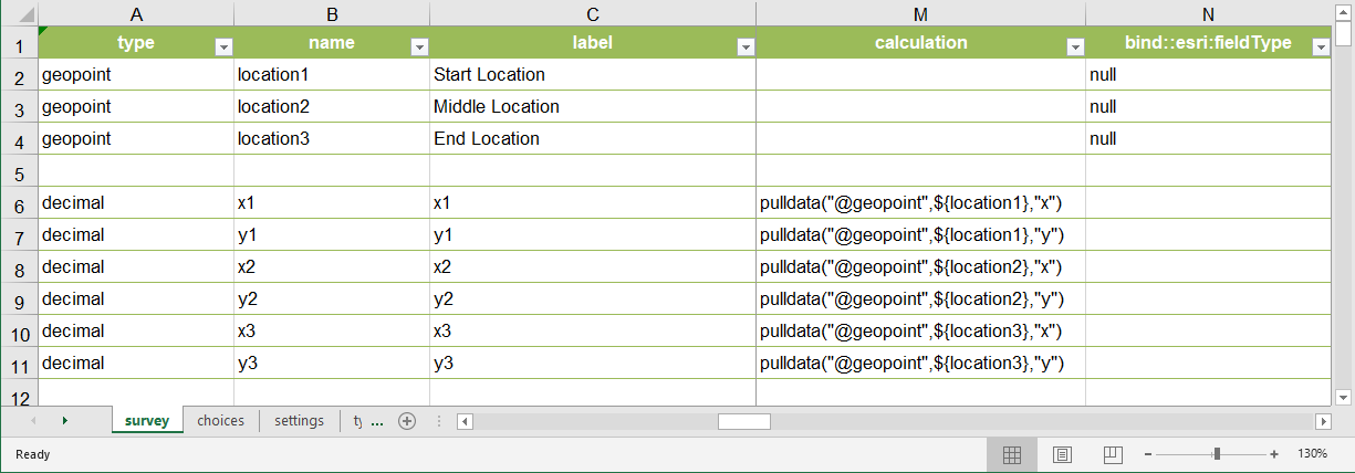
one approach you can take is to set the esri:fieldType column to null, as shown in the screenshot below.
questions tagged with null in the field type are kept in your form, but do not have a corresponding field in the feature layer. For this reason, you can add as many geopoints as you like to the form. Using calculations you can persist the XY values in separate fields. The limitation here is more about how many SHAPE fields you can have in an ArcGIS layer (the limit is one).
I am also attaching the XLSFile.

- Mark as New
- Bookmark
- Subscribe
- Mute
- Subscribe to RSS Feed
- Permalink
This has a slight flaw in the design in that every point needs to be in a separate repeat section so that it exists in separate tables if not when publishing the result you end up with this warning... but then as separate points it is very clumsy it would be great to capture the geopoints all within the single map view and have them recognised as multiple location values of one feature in one location map window..
I altered the format a bit from your original as I was not getting any results on first try. too.
- Mark as New
- Bookmark
- Subscribe
- Mute
- Subscribe to RSS Feed
- Permalink
If this captures the XY coordinates, how can I use the same method to also capture searched for place names as well?
- Mark as New
- Bookmark
- Subscribe
- Mute
- Subscribe to RSS Feed
- Permalink
Hi @IsmaelChivite,
When I use the form as laid above using only two points, the coordinates for both points are the same. I can't seem to move the second point coordinates.
Regards,
Craig
- Mark as New
- Bookmark
- Subscribe
- Mute
- Subscribe to RSS Feed
- Permalink
Hello,
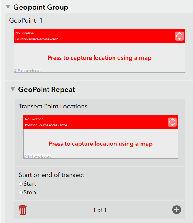
This should be possible, but you might want to think about having the linear points contained within a "repeat" with a question that asks if it is the starting or ending point.
What will happen is Survey123 Connect will build a schema that has one main point feature class that contains all of the survey information from your form that is outside of the repeat. There will also be another point feature class that is "related" to the main point feature class using a one-to-many relationship. So, if you were to click on the main survey point, then you would also be able to identify all of the point that are related to the main survey.
It will looks something like this within the XLSX form and then something like the second screen shoot within the Survey123 field app.


Good luck,
Mike
- Mark as New
- Bookmark
- Subscribe
- Mute
- Subscribe to RSS Feed
- Permalink
Hello ENV Group,
From what I understand, you are correct that only one geopoint question can be asked on a form, but you can have many geopoints captured within a repeat. A possible workflow:
Problem 1: Capturing points and lines (represented by 1+ points):
- Ask a 'select_one' question to determine whether the site is a point or a line.
- If a point, present the geopoint question.
- If a line, present geopoint question within a nested repeat to collect points along the line
I've attached a sample template implementing an indexing function in the calculation field identifying the point index along a transect (index starts at 0).
HTH and good luck!
Yuriko