- Home
- :
- All Communities
- :
- Products
- :
- ArcGIS Survey123
- :
- ArcGIS Survey123 Questions
- :
- Re: Use pull data function for geolocation
- Subscribe to RSS Feed
- Mark Topic as New
- Mark Topic as Read
- Float this Topic for Current User
- Bookmark
- Subscribe
- Mute
- Printer Friendly Page
Use pull data function for geolocation
- Mark as New
- Bookmark
- Subscribe
- Mute
- Subscribe to RSS Feed
- Permalink
I am a high school science teacher that has been conducting frog surveys with my students for several years. I am working on moving data collection to survey123 so that we can visualize data for several established survey locations. I would like to either collect data in the field using survey123 or upload it into survey123 from paper forms.
The issue I'm running into is how to connect the geolocation for pre-established survey locations with all of the rest of the data. I don't want to use the "geolocate" function in survey123 because I want the data to always be tied to an exact lat/long. If there is an easier way to do this on the front end (survey123) or the backend (ArcGIS online), please let me know!
After making my initial survey123 form I found this video. I was so excited when I successfully created calculation fields and got the lat/long to show up in the Survey123 connect app! However, when I tried saving/publishing the form, I ran into my first problem: the calculated fields didn't show up in the v1 version of my form on the mobile version. Next, I tried saving the form into a v2. I realized there was probably an issue with my v1 because I entered form data before adding the calculation fields.
Frogwatch form v1 https://arcg.is/1efyrX1
Frogwatch form v2 https://arcg.is/4qX4L0
I am currently getting this error message when I try to enter data into the v2 form:
- Failed to load data from https://www.arcgis.com/sharing/rest/content/items/6da80f5137fd4ea6881caaaf2c1afedf/info/media/frog_s....
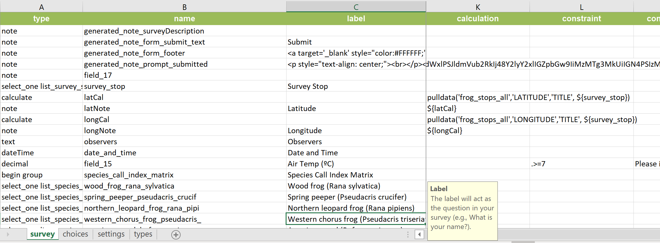
Here is the geolocation file for the survey locations "frog_stops_all"
LATITUDE | LONGITUDE | TITLE |
44.62459 | -85.7983 | 2018A_Bush_Rd_1st_south_Gonder_ |
44.6095 | -85.8004 | 2018B_Bush_Rd_south_of_Bluebird_Ct_ |
44.60028 | -85.8056 | 2018C_Betsie_River_Rd_west_Pinecone_D |
44.61022 | -85.8175 | 2018D_S_Betsie_River_Rd_north_of_Fred |
44.62206 | -85.8176 | 2018E_S_Betsie_River_Rd_north_of_Old_ |
44.63561 | -85.7627 | 01_IPR |
44.63732 | -85.772 | 02_Sawmill_Rd_north_ |
44.63532 | -85.7774 | 03_ICA_Maintenance |
44.62967 | -85.7867 | 04_Diamond_Park_Rd |
44.63464 | -85.7984 | 05_Gonder_Rd_north_ |
44.63956 | -85.7908 | 06_Bridge_Lake_area |
44.64411 | -85.7841 | 07_Riley_Rd |
44.65356 | -85.765 | 08_Commercial_Ave |
44.65407 | -85.7536 | 09_Birch_Rd_Tonawanda |
44.65225 | -85.749 | 10_end_of_Birch_Rd |
- Mark as New
- Bookmark
- Subscribe
- Mute
- Subscribe to RSS Feed
- Permalink
Hi Jenna, there is a slight difference between the mobile URL and the Browser.
Webform in browser:
https://survey123.arcgis.com/share/850b9bf3bcb542f581ad4829626d9bbc?field:identificatie={identificat...}
Form on mobile
arcgis-survey123://?itemID=850b9bf3bcb542f581ad4829626d9bbc&field:identificatie={identificatie}¢er={expression/expr1},{expression/expr0}
Notice especially the & after the id of the mobile form, whereas it is a ? in the browser.
Furthermore i rather use arcade to determine the lat/lon since when the feature can be moved (Geometry($feature).x and.y OR Centroid($feature).x for Polygons)
- Mark as New
- Bookmark
- Subscribe
- Mute
- Subscribe to RSS Feed
- Permalink
Thanks for the reply @bsneller_esrinederland !
I somewhat follow the difference in the two URLs that you pointed out but don't understand how to fix it.
Could you point me to a reference for the arcade lat/long information? I'm not a very advanced user and have only done very limited language operations (typically SQL in ArcGIS Online). Or perhaps give me a little more direction about how to incorporate those into the form?
In my original post, I could not figure out how to get photos embedded but the image icon is showing up now. Included are screenshots from Survey123 connect.

