- Home
- :
- All Communities
- :
- Products
- :
- ArcGIS Survey123
- :
- ArcGIS Survey123 Questions
- :
- Re: Survey123 send error: No mapping exists from o...
- Subscribe to RSS Feed
- Mark Topic as New
- Mark Topic as Read
- Float this Topic for Current User
- Bookmark
- Subscribe
- Mute
- Printer Friendly Page
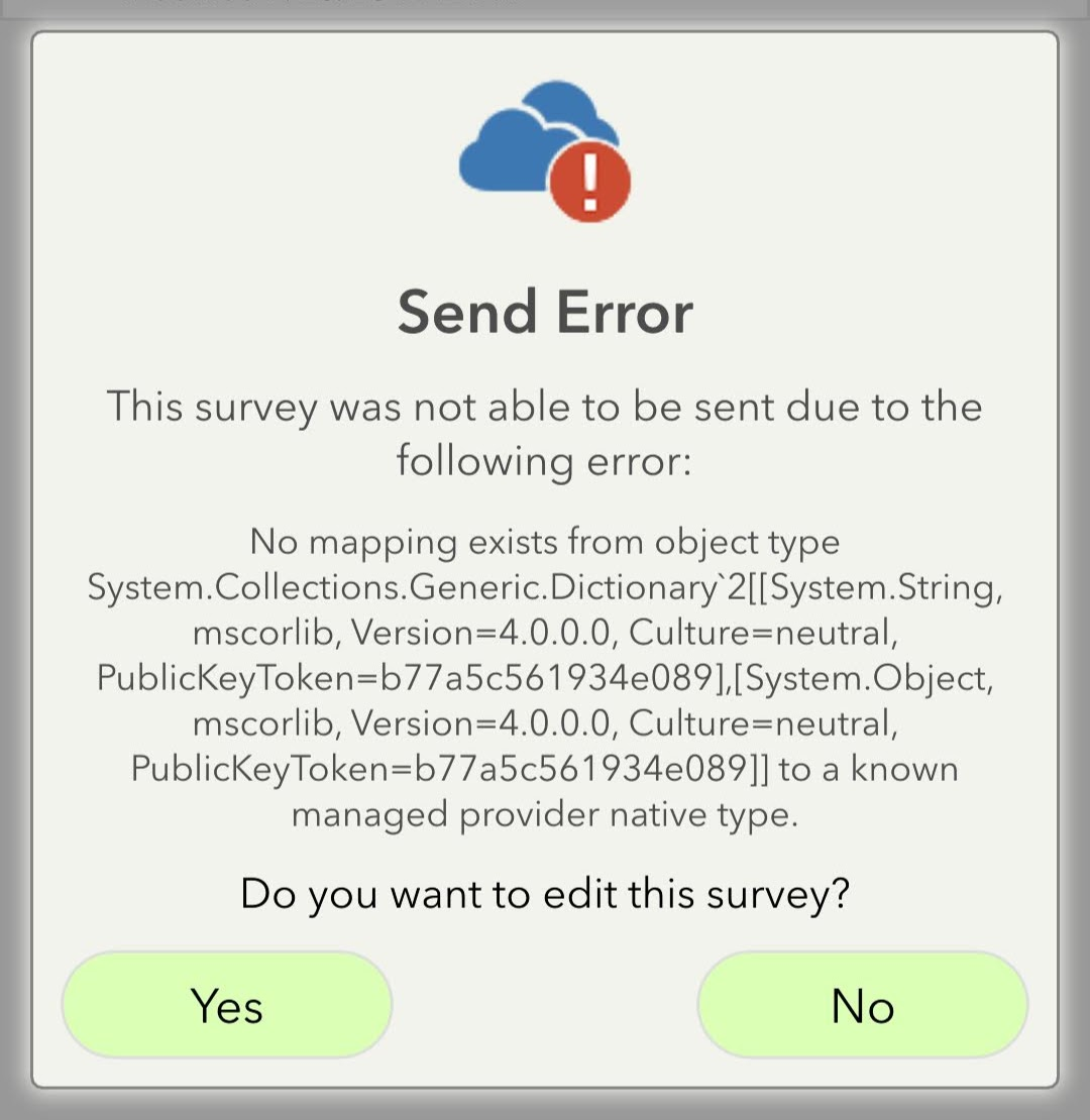
Survey123 send error: No mapping exists from object type to a known managed provider native type.
- Mark as New
- Bookmark
- Subscribe
- Mute
- Subscribe to RSS Feed
- Permalink
Looking for help with a Send Error in Survey123. You can see the error below, and I've attached the xls form too.

Solved! Go to Solution.
Accepted Solutions
- Mark as New
- Bookmark
- Subscribe
- Mute
- Subscribe to RSS Feed
- Permalink
Hi Rachel,
I just had a look at your xslx file and now I see the problem. It appears you are using several geopoint questions all in the same layer, this is not supported. As per ArcGIS feature layers, there can only be one geometry field. Each geopoint question (or geotrace or geoshape) is a geometry field, so you can not have more than one in the same layer.
If you want to use more than one map question (geopoint) to collect data, you need to put them in seperate layers, via a repeat, or you can use the "null" esri field type, so that the question can be used in the survey, but the data/geometry not stored in the feature layer.
Regards,
Phil.
- Mark as New
- Bookmark
- Subscribe
- Mute
- Subscribe to RSS Feed
- Permalink
Hi Rachel,
The screenshot of the error doesn't appear to load and/or is just showing a grey circle.
Are you seeing this error in the web app pr field app? Can you confirm the version you are using, and what version on the website is set in the settings? Do you have version locking on? What was last version the survey was published with?
Also did you create this survey with web designed or Connect?
Regards,
Phil.
- Mark as New
- Bookmark
- Subscribe
- Mute
- Subscribe to RSS Feed
- Permalink
Hi Phil,
Thanks for taking a look.
The error is coming up in the field app (version 3.9.149). In the website settings, version locking is on and was published under version 3.9. The survey was created using Connect.
Attempting to share the error again. Hopefully it comes through this time.
Thanks again,
Rachel
- Mark as New
- Bookmark
- Subscribe
- Mute
- Subscribe to RSS Feed
- Permalink
Hi Rachel,
Are you using AGO or Enterprise, if Enterprise what version of Portal and how is it configured?
How did you create and publish the feature service, was it existing or new? If existing how was it created? It seems something is wrong with the geometry for the feature layer?
Have you ever been able to submit a survey to this feature layer from the field app?
Regards,
Phil.
- Mark as New
- Bookmark
- Subscribe
- Mute
- Subscribe to RSS Feed
- Permalink
Hi Phil,
I am using AGO. This is the first survey I've ever created and it's a new feature service, and I've never been able to submit a field survey.
-Rachel
- Mark as New
- Bookmark
- Subscribe
- Mute
- Subscribe to RSS Feed
- Permalink
Hi Rachel,
I just had a look at your xslx file and now I see the problem. It appears you are using several geopoint questions all in the same layer, this is not supported. As per ArcGIS feature layers, there can only be one geometry field. Each geopoint question (or geotrace or geoshape) is a geometry field, so you can not have more than one in the same layer.
If you want to use more than one map question (geopoint) to collect data, you need to put them in seperate layers, via a repeat, or you can use the "null" esri field type, so that the question can be used in the survey, but the data/geometry not stored in the feature layer.
Regards,
Phil.
- Mark as New
- Bookmark
- Subscribe
- Mute
- Subscribe to RSS Feed
- Permalink
Hi Phil,
I was beginning to think that was the issue when you mentioned something was wrong with the geometry, and that make perfect sense. I'll follow your recommendation for the null esri field type.
Thank you for all your time and help.
Rachel
- Mark as New
- Bookmark
- Subscribe
- Mute
- Subscribe to RSS Feed
- Permalink
Hi Phil,
I'm having a similar issue with my own survey, however, the bind::esri:fieldType is set to null for all but 1 of the 4 total geometry types in my survey (3 outside of a repeat, 1 inside a repeat). The geometry question that I have without null as the fieldtype is a polygon type (geoshape) outside of the repeat. Could you share what you think may be going on here? I am still getting the same error as described above.
Regards,
Leigh
- Mark as New
- Bookmark
- Subscribe
- Mute
- Subscribe to RSS Feed
- Permalink
Hi @Anonymous User,
Similar to 'leightmaes' question below. I have a survey with multiple geopoint questions but all but one having "null" in the bind::esri:fieldType column but when I try to submit a survey I receive the following error "No mapping exists from object type ESRI.ArcGIS.Client.Geometry.MapPoint to a known managed provider native type."
Any idea why this might be occuring?
Cheers
- Mark as New
- Bookmark
- Subscribe
- Mute
- Subscribe to RSS Feed
- Permalink
Hi @JamesBailey,
When you published the survey, was the first geopoint question null field type? In that case did it create a table only, not a layer, meaning there is no geometry?
You can check the schema in Connect and the Schema tab, so see if it is a table or layer. It sounds as though you have a table, but are trying to send geometry via the geopoint to the table.
Regards,
Phil.