- Home
- :
- All Communities
- :
- Products
- :
- ArcGIS Survey123
- :
- ArcGIS Survey123 Questions
- :
- Re: Survey123 geopoint failing within a repeat
- Subscribe to RSS Feed
- Mark Topic as New
- Mark Topic as Read
- Float this Topic for Current User
- Bookmark
- Subscribe
- Mute
- Printer Friendly Page
Survey123 geopoint failing within a repeat
- Mark as New
- Bookmark
- Subscribe
- Mute
- Subscribe to RSS Feed
- Permalink
- Report Inappropriate Content
I have developed a Survey123 survey with a primary record which includes a geopoint, and related records (1-n) also containing a geopoint. In all cases I move the marker to exactly where I want location recorded.
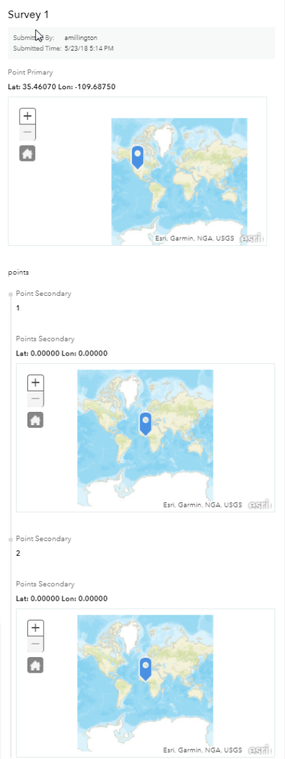
The location is recorded just fine in the primary record, but in all related records no location is recorded. The location is lat: 0.0000 and lon: 0.0000.
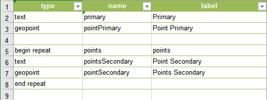
Here is a simplification, for your perusal: What am I doing wrong?
Spreadsheet entry.

Result in Survey123

- Mark as New
- Bookmark
- Subscribe
- Mute
- Subscribe to RSS Feed
- Permalink
- Report Inappropriate Content
Hi Anne,
This is a known issue, geopoint questions inside a repeat do not automatically get a location when loaded or on adding a new repeat record. We have an open issue for this in our backlog, and I have added your comments to the issue.
In the meantime you need to manually press the GPS location button to apply the current location to the geopoint question.
Phil.
- Mark as New
- Bookmark
- Subscribe
- Mute
- Subscribe to RSS Feed
- Permalink
- Report Inappropriate Content
Hi Phil,
I tried pressing the GPS location button, and it moved the marker and registered in the survey form, but the end result was the same once submitted.
Do you think this issue will be addressed in the near future? I will need to come up with some kind of workaround, as having multiple sub-locations related to a primary location was a real point winner for the application. I guess users could record their sub-locations with a dedicated gps device and add the values in later, but that adds a step. Since we don’t require a high degree of accuracy, having this taken care of within the application is quite a boon. We can always go with one location for all observations within a certain area for a while, and still realize value from the survey app.
I will watch for issue resolution!
Many thanks
- Mark as New
- Bookmark
- Subscribe
- Mute
- Subscribe to RSS Feed
- Permalink
- Report Inappropriate Content
The way I do it is move the Primary Point up to Collector then launch the Secondary Forms from there. This is especially handy if the Primary Points are pre-established - adds a spatial component vs just forms. See more info in my post here https://community.esri.com/groups/survey123/blog/2016/07/30/understanding-survey123s-custom-url-sche...
The other way is to fill out 1 form per Secondary Point then link them together with some type of Key and a relationship class. To take the next point open a form from Sent or Outbox and pick create a copy (vs edit) then you can just change just the info you need to making it pretty fast.
Hope that helps.
- Mark as New
- Bookmark
- Subscribe
- Mute
- Subscribe to RSS Feed
- Permalink
- Report Inappropriate Content
Thank you so much, Doug, these are some very useful suggestions.
I will probably end up just adding a key to the so-called Secondary Forms, as a lot of what I do with the data subsequently requires SQL Server anyway.
I appreciate the deeper description of the custom URL, and will definitely use the copy method for speeding the process.
Really really helpful!!
- Mark as New
- Bookmark
- Subscribe
- Mute
- Subscribe to RSS Feed
- Permalink
- Report Inappropriate Content
Hi Philip,
I am trying to generate a report as well using Survey123 website. In my survey my true geolocation is collected in repeat form. But currently can only view random geolocation point which has been collected in primary from on Survey123 website data page. Is there any way I can see the geolocation point collected in repeated table instead of primary geolocation point?
Thanks,
Anu
- Mark as New
- Bookmark
- Subscribe
- Mute
- Subscribe to RSS Feed
- Permalink
- Report Inappropriate Content
Hi Anu,
The geometry of a feature in AGO/Portal and Survey123 website is governed by the geopoint/location question in the parent layer, or if it doesn't have one it will automatically get the geometry of the location when the survey was collected. It is not possible to display the related points in a web map as markers, or in survey123 data tab as it will always display the parent later feature geometry location. The same applies for the main map in the feature report template.
Regards,
Phil.
- Mark as New
- Bookmark
- Subscribe
- Mute
- Subscribe to RSS Feed
- Permalink
- Report Inappropriate Content
Thanks Phil.
- Mark as New
- Bookmark
- Subscribe
- Mute
- Subscribe to RSS Feed
- Permalink
- Report Inappropriate Content
Hello James Tedrick, Adam Daily, Survey123 Geonet
With the latest versions (3.4 and 3.5) is a solution proposed? Is there a way to see the location point collected in a repeated table instead of grouping them under the primary location point? Where is it a Survey123 limit? Does a solution exist by integrating collector? I am a follower of any solution going even to development because it is essential for our application.
Really really helpful!!